 |
| Some parameters were measured immediately after sampling. |
On August 14, 2001, a team of ten scientists from Germany, Austria, Slovakia,
Hungary, Yugoslavia, Bulgaria and Romania boarded Germany’s Argus and
Hungary’s Széchényi research ships to begin the six-week
expedition. Their mission was to collect and analyse samples taken from
the River for 140 different parameters ranging from biological indices and
chemical pollutant levels to indicators about the state of aquatic flora,
fauna, and micro-organisms.
The survey – referred to as the Joint Danube Survey (JDS) – was
initiated by the International Commission for the Protection of the Danube
River (ICPDR) to improve the validity and comparability of water quality
data received from its regular monitoring programme, the Trans-National
Monitoring Network (TNMN). The JDS was funded by the governments of Germany
and Austria, while each participating country provided in-kind contribution
by establishing a national team of experts to work alongside international
JDS experts on their national stretch of the Danube and in the national
reference laboratories.
The team followed a carefully prepared sampling plan, taking samples of
water, bottom sediments, suspended solids and mussels at 98 selected river
cross-sections. At the same time, biologists collected samples of the river
fauna and micro-organisms, including samples of organisms living on the
river bottom, macro- and microalgae attached to stones and soft sediments,
water plants, algae, bacteria, and floating animals carried by water.
Some of the parameters were measured on board the laboratory ship Argus
immediately after sampling. The rest of the samples were sent at regular
intervals to the JDS central storage facility at Vituki in Budapest, where
they were sorted out and sent on to the nine JDS reference laboratories
in Germany, Austria, Slovakia and Hungary. At these laboratories, teams
of experts analysed the data to provide one of the most comprehensive and
sophisticated analyses of the Danube’s water that has ever been made.
 |
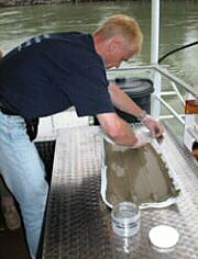
| Collecting samples of the Danube for laboratory analysis |
Since chemical and biological conditions of rivers are greatly influenced
by geomorphology, i.e. landscape features, characteristics such as discharge,
slope runoff, soil composition, and sediment transportation must be taken
into account when selecting sampling sites. In terms of geomorphology, the
Danube River Basin is marked by great longitudinal diversity, which in turn
is reflected in the broad chemical and ecological variation from the source
of the River to its mouth.
For the purpose of selecting sampling sites for the Survey, the River was
divided into three major reaches: the Upper Danube, characterized by frequent
damming and little free-flow, the Middle Danube, marked by free-flow, and
the Lower Danube, another free-flow section of the River. Each of these
major reaches was further divided into three sub-reaches, making a total
of nine distinct geomorphological reaches, each marked by particular landscape
features and anthropogenic impacts. In this way, values from individual
sampling sites within a single reach could be consolidated to provide a
general characteristic for the reach as a whole. Establishing characteristics
of the different reaches was valuable because it allowed the values of parameters
to be compared. Furthermore, patterns for each parameter could then be determined
for the entire length of the River based on how the values varied between
the reaches. This is a very useful procedure in comparing areas that differ
in terms of geomorphology and anthropogenic effects.
JDS has produced a reliable and consolidated picture of the water quality of the Danube and its major tributaries in terms of chemical, biological and microbiological parameters. The findings highlighted certain issues of concern. Firstly, ‘hot spots’ were identified that contained large amounts of pollutants listed in the EU Water Framework Directive as priority substances. Secondly, nutrient concentrations in the whole Danube – and especially in its middle part – were found to be high. Another reason for concern relates to overall pollution by bacteria and heavy metals. It is important to note that the Survey was for the most part deliberately conducted during a low-water period, and that consequently the observed concentrations of chemical pollutants represent the worst-case scenario.
 |
| Experts identified a list of hot spots. |
Biodiversity
The collected data reveal a high degree of biodiversity. More than 1,000 aquatic species and higher-level organisms were identified during the Survey. These species included small animals living on bottom sediment and drifting in water, as well as algae, water plants and mosses. The opening of the Main-Danube Canal in 1992 led to an intermigration of river fauna between the Rhine and the Danube, and has resulted in an increase in biodiversity in the Danube. The consequences of this migration will have to be monitored in order to ensure that the increase in biodiversity is sustainable and that the arrival of new species does not cause a deterioration of the typical Danubian species.
Organic pollution
The organic pollution varied between water quality class II (according
to the Austrian classification scheme this means moderately polluted) and
II/III (critically polluted). Many tributaries and side reaches of the river
were found to be more polluted than the main stream; some of these even
reached water quality class III (strongly polluted), e.g. the Sio River
in Hungary. In some tributaries (e.g. the Iskar in Bulgaria, and the Olt
and the Arges in Romania) no macro-invertebrates at all were found - a clear
indication of an even higher level of organic pollution, possibly to the
level of toxicity. This situation might be partially caused by the fact
that sampling was carried out in low-water periods.Eutrophication (concentration
of nutrients)
The overproduction of algal biomass is a serious concern because it can
lead to a variety of problems such as habitat destruction and a decrease
in biodiversity. Particularly high concentrations of algal biomass/chlorophyll-a
were found in the Hungarian stretch of the Danube downstream from Budapest.
This indicates elevated nutrient concentrations in this reach of the Danube
River.
Microbiological pollution
Microbiological (bacterial) indicators are widely applied for the assessment of anthropogenic impacts. Such impacts involve faecal pollution (caused by untreated or insufficiently treated sewage) or a variety of diffuse impacts from farm land and pasture (manure). Faecal bacteria also indicate a potential presence of pathogenic bacteria, viruses, and parasites that can be dangerous to human health. The highest values in microbiological pollution were observed in the tributaries (especially in the Russenski Lom in Bulgaria and the Arges in Romania) and the side arms (the Moson Arm; the Soroksar Arm in Hungary).
Heavy metals
Specific heavy metal pollution hot-spots were detected. The highest concentrations in water were observed in the Rusenski Lom, the Iskar, and the Timok tributaries in Bulgaria. An analysis of sediments revealed concentrations exceeding the German quality targets for cadmium, lead and zinc in the Iskar River and for arsenic and copper in the Timok River. Therefore, these two tributaries are to be considered sources of contamination.
Pollution from navigation
Navigation along the Danube is the main cause of oil pollution found during JDS sampling. Samples of water, suspended solids and sediment were analysed for petroleum hydrocarbons. The highest concentrations of petroleum hydrocarbons in sediments and suspended solids were found in the Middle Danube reach.
Pesticides
Out of 23 pesticides under investigation only atrazine and desethylatrazine could be found along the Danube. Atrazine was found in high concentrations in the Sava River (0.78 µg/l), affecting the Danube downstream from the Sava confluence.
Chemical pollutants
Significant concentrations of certain harmful chemical pollutants featuring on the EU Water Framework Directive List of Priority Pollutants were found in bottom sediments as well as in suspended solids. Most of the higher concentrations of such pollutants were found in the Yugoslav section of the Danube, which is thought to be caused by the use of alkylphenol-containing detergents in this region. These compounds were monitored in the Danube River for the first time during this Survey.
 |
| Lessons learned from the JDS should serve
as a basis for future activities. |
The results of JDS will form a major contribution towards the implementation
of the EU Water Framework Directive in the Danube River Basin. The Directive
aims to develop an integrated and coordinated river basin management plan
for the entire Danube River Basin and to achieve a good status of surface
water and groundwater by 2015.
As a first step, it requires that a comprehensive characterization of the
river basin and an assessment of significant impacts be made by 2004. The
data and information yielded by JDS is intended to fulfill these requirements
of the Directive and will form an important basis for this work.
JDS fulfills this first step well in that it provides an excellent framework
for harmonizing sampling, sample preparation, and analytical methods used
in different Danube countries. The jointly collected samples analysed on
board the Argus and in the national laboratories provided a unique opportunity
for scientists to compare their results, harmonize methodologies, and improve
the quality of their analytical work.
The close contact that JDS researchers established during the Survey with
country representatives, the media, local experts and the public, created
a forum for raising public awareness about pollution reduction policies
and activities in the Danube River Basin.
Lessons learned from the Joint Danube Survey should serve as a basis for
future activities. In general, JDS confirmed the priorities set by the Joint
Action Programme (JAP) of the ICPDR. JAP will remain the framework for action
but JDS will contribute to a more specific identification of pollution sources.
As preparation for the forthcoming meeting of the ICPDR at the end of November
2002, the Danubian Countries will evaluate the results of JDS with a view
to identifying follow-up activities at the national level and priorities
for coordinated measures to be taken by the ICPDR.
The Danube experts involved in the Survey have also agreed that a set of
specific publications with more detailed evaluation of data should follow
the JDS Report. This should support the general focus of the ICPDR towards
the implementation of the EU Water Framework Directive.