 |
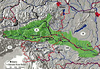
| Map of the Drava from its source to its confluence with the Danube |
For the first 750 km of its course it is a mountain river receiving smaller
tributaries, the most important of which are the Isel (confluence at Lienz,
Austria) and the Gail (Villach, Austria). In its second stretch, from Villach
to Barcs (Hungary), the Drava is turbulent and still fast-flowing, and traffic
is limited to rafts. In this stretch, the river passes through Maribor (Slovenia)
and flows through north Croatia, where it is joined from the northwest by
its largest tributary, the Mura. From shortly after the confluence with
the Mura, the Drava flows 145 km southwest, and forms a large part of the
border between Croatia and Hungary. In its lowest stretch, from Barcs to
its confluence with the Danube (at the border with Yugoslavia), the river
is navigable by small ships. At its confluence with the Danube, the Drava
is 322 m wide.
Over the last century, economic and social pressures on the river have grown
and have been impacted by the changing political and historical conditions
of the countries through which the Drava flows. In Austria, for example,
the pressure that started in the early part of the last century and was
leading to a deterioration of riverine conditions was finally removed and
the situation was reversed by a bold and far-sighted project - the LIFE
Project described below. In the formerly planned economies of the countries
further downstream (Slovenia, Croatia, and Hungary) development along the
river was more measured till the 1990s, but pressure has increased dramatically
since then.
 |
| Not all human activities are at odds with nature |
With an average water flow of more than 100 m3 per second, the Drava is
one of Austria’s largest rivers. As a typical Alpine river, it was
once a wild river with side arms, gravel banks, islands, and oxbows. It
hosted large populations of typical fish species such as the Danube salmon,
birds such as the kingfisher and common sandpiper, and other animals such
as the Eurasian otter. Its floodplain area was regularly inundated. Today,
only remnants of the original landscape and species populations exist because
the river has come under increasing pressure from agriculture and housing
since the beginning of the last century; the resulting regulation was systematic,
and considerably changed the river’s character.
The consequence of these decades-long impacts on the Upper Drava was a degradation
of natural freshwater habitats, including alluvial forests, oxbows, and
natural river stretches. In the long term, channelling also deepened the
riverbed by 2cm per year and led to increased flow velocity, which in turn
caused a lowering of the groundwater level. In addition to this, the deterioration
of natural flood-retention capacity increased the risk of flooding.
Because of these problems, the Water Management Authority of Carinthia,
the Austrian province through which the Drava flows, and WWF Austria, developed
a LIFE project to work on a 57 km-long section of the Drava in Carinthia.
Co-financed by the EU and the WWF, this Euro 6.3 million project, which
ran from 1999 to 2002, was one of the largest river restoration projects
in Europe. Its main aims were:
• to maintain and improve (natural) flood protection and the river’s
dynamic processes; and
• to improve the natural habitats and increase the population of typical
species.
The operational strategy was to restore three ecological "core zones”
that cover 7 km of the river. The river bed was to be widened and former
side-arms reconnected in these zones. It was also planned to recreate natural
floodplain forests, protect endangered species, and create a combined biotope
system along the whole valley.
As the project neared completion, new measurements revealed several positive
results. These included:
• better flood prevention. On 200 hectares, natural flood retention
capacity improved by 10 million cubic meters;
• reduced flow velocity, which slows down a flood wave (reduction estimated
at more than one hour);
• recreated natural Alpine and floodplain habitats. Around 50 –
70 ha of islands, gravel banks, steep banks, etc, with their typical species
(Danube salmon, common sandpiper, kingfisher, etc) were recreated;
• stoppage of river bed deepening, and possibly even a raising of the
river bed;
• doubling of certain fish populations, e.g. the greyling.
In effect, this project has shown that river restoration works, and is particularly
good as a strategy to improve flood protection. It is sustainable and cheaper
in the long run; it increases biodiversty and improves the recreation value
of the river for the human population. This is in contrast to river-engineering
measures such as channelisation, or flood protection with dykes, which cause
long-term problems such as river bed deepening and the loss of natural flood
retention capacity. On the Upper Drava, the Water Management Authority of
Carinthia, together with WWF, is working on a "follow up” project
to restore other regulated parts of the river in order to fulfil the objectives
of the WFD.