 |
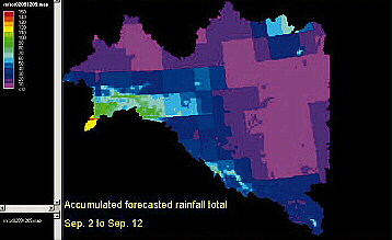
| Accumulated rainfall for parts of the Danube catchment over the period of September 2-12, 2002 |
Examples include the Meuse and the Rhine in 1993 and 1995, the Oder in
1997, and the Elbe and the Danube rivers in August 2002. Besides the large-scale
floods, there are other observations that support the projections of an
increase in severe floods in Northern and Northwestern Europe. For example,
in England and Wales the 24-months period ending in March 2001 was the wettest
in the 236-year time series of precipitation.
October 2000 to March 2001 precipitation was also exceptional in Brittany
(France), where the normal annual rainfall was exceeded by 20 to 40% in
parts of the region. A third consecutive year of severe flooding occurred
in Hungary and parts of Eastern Europe in March – the Tisza reached
its highest level in more than 100 years since its previous record of 1888.
Reducing flood risk is, therefore, an important issue that needs to be addressed
not only at the local level but also on the European scale. Questions that
need to be answered include: how did historic changes in land use across
Europe impact the risk of flooding and how can new land use planning reduce
it? How does the expected climate change influence flood risk? What damage
can be expected? Can we improve the lead time in flood forecasting so that
both authorities and citizens are better prepared?
In order to answer those questions on the European scale and to assist policy
decision making, the Joint Research Centre of the European Commission has
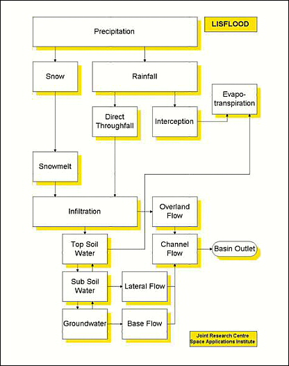
developed LISFLOOD hydrological model.
LISFLOOD is a model that has been developed explicitly for the simulation
of floods in large European drainage basins. It is capable of simulating
large areas while still maintaining a high spatial and temporal resolution,
proper flood routing methods and physical process descriptions. It also
assesses the impact of changes in land use, river geometry, and the effects
of climate change on flood risk. LISFLOOD can further simulate special structures
such as water reservoirs and retention areas by indicating their location,
size and inflow and outflow boundary conditions.
LISFLOOD has been extensively tested for several transnational catchments
– amongst them the Meuse and the Oder. For these catchments high-resolution
data are available, in particular in terms of river dimensions. The model
is also set up for the whole of Europe, but on that scale river cross-sections
are estimated as a function of upstream area only.
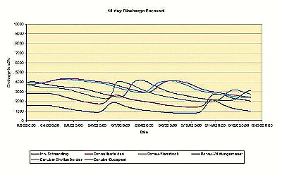 |
| Associated discharge curves for selected stations. The figure shows the prediction of two flood waves passing from the tributaries to through the main river with a lead time of 4 and 8 day |
The main applications of the LISFLOOD model include:
• Scenario modelling. In close collaboration with the Oder Commission
(IKSO) more than 80 scenarios were simulated for the Oder River ranging
from land use changes (e.g. afforestation) to technical measures (e.g. new
reservoirs, changed reservoir management, retention areas, new dykes, floodplain
enlargement). The project is now terminated (1999-2002) and the results
of the scenarios are used as technical assistance in designing a Flood Action
Plan for the Oder River. Over the coming years, the scenario modelling activities
will be extended to include a number of other trans-national rivers including
the Elbe and the Danube rivers.
• A 10-day flood forecast on European scale. The European Flood Forecasting
System (EFFS) project (2000-2003) is a first attempt to combine state-of-the-art
expertise in meteorology and hydrology on European scale. The aim of EFFS
is to issue a 10-day pre-warning for floods. At present, the system runs
on 5km for the whole of Europe and on 1km for selected test catchments.
It addition, it incorporates information on the uncertainty of the prediction.
The development of a pan-European pre-operational flood alert system is
envisaged during the coming years.
• Flood risk on European Scale. Floods are typically dealt with at
the national level. Since the definition of flood risk varies between different
countries, a transboundary comparison is normally difficult. LISFLOOD overcomes
this difficulty because it is set up for the whole of Europe and runs for
a period of 10 years. Statistics such as minimum discharge, maximum discharge
or flood frequency are calculated for every grid point, which allows a flood
risk map for the whole of Europe to be produced.
When in mid-August 2002 the so-called biggest flood of the century swept
through the Elbe and the Danube river basins, the performance of the LISFLOOD
modelling system could be tested under real-time forecasting conditions.
It was in fact the European Commission that had made this request to the
JRC. With the link to weather forecast data from the Deutsche Wetterdienst,
that was established previously, a 7-day forecast could be issued the same
day the request was made.
 |
From August 27th onwards, a forecasting lead time of 10 days was achieved
using also medium-range weather forecasts from the European Centre of Medium
Range Weather Forecasting (ECMWF). Daily discharge forecasts were produced
over a period of three weeks. Obviously, it was not possible to obtain and
incorporate high-resolution river dimension data for both catchments in
that short time, nor was it possible to make calibration runs prior to the
forecasts. The forecasts were therefore seen as an attempt to qualitatively
predict the flood risk beyond 48 hours. In addition, dyke breaks are not
considered in the model, which makes a comparison with observations difficult.
LISFLOOD activities are planned to be extended over the coming years to
include scenario modelling and medium-term flood alert forecasting in the
Danube catchment in cooperation with the ICPDR.