![]()
Industrial activities in particular - often associated with the shortening of water stretches - have left their sad mark on the floodplains, and so have infrastructure projects. Changes in the natural landscape that started in 1870 along the Danube in Baden-Württemberg (Southwest Germany) have continued to this day.
Integrated Danube Programme - a coordination platform for water management activities
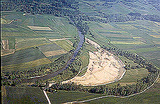 |
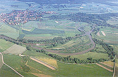 |
| The transfer of the Danube during the building site phase: June 1992 (left) and June 1999 (right) | |
In response to the lasting water management problems that had long haunted
them and spurred by the big flood that hit Baden-Württemberg in 1990, the
local authorities launched the "Integrated Danube Programme” designed
to serve as a platform for coordinating water management activities in the entire
region. In the meantime, the Integrated Danube Pro-gramme has been accepted and
made binding for all projects and activities planned or conducted in the district.
These are premised on the existing consensus that environmental protection and
flood protection are closely interconnected.
Based on an integrated concept of restoration to near-natural conditions, the
Danube/ Lake Constance water authority and the district administration of Tübingen
have cooperated with various other authorities, local governments, munici-palities
and specialists to develop a portfolio of 219 specific activities. The portfolio
includes the setting up of 30 pro-tected areas, 66 flood protection measures,
64 rehabilitation and 55 measures to secure ecological connectivity.
The first step in the direction of sustainable water management, in line with
the Integrated Danube Programme, was to rehabilitate the Blochinger Sandwinkel,
a floodplain area close to Blochingen in the district of Sigmaringen. The work
was carried out between February 1992 and June 1993. The bulk of the EUR1m project,
i.e. EUR 400,000, was spent for the purchase of a 25-hectar area which was then
freed from all agricultural activity and the free-flowing stretch of the river
was enlarged from 1,000 to 1,400 meters.
However, in order to ensure flood protection for the nearby town of Blochingen,
it was necessary to maintain the old Danube riverbed (flood route). To secure
water flow through the side arms, two rough ramps measuring 2.2 and 1.6 meters
in height (incline 1:18) bring the level of the river bottom back to the level
before engineering correction meas-ures were taken. Near larger outlets, the old
Danube functions as a flood hollow. The water division has been established in
a way to make sure that the old Danube bed never becomes dry.
Profile assessments at 29 separate transects has showed significant movement of
sediments over time. In the frame of a pilot project, Dr. Dittrich and his team
from the Institute for Water Management and Cultural Technology of the Univer-sity
of Karlsruhe investigated the erosion and sedimentation in the river. The largest
movement of sediments took place during the first two years after construction.
During this period the course of the main channel and inclination varied considerably.
A process of self-stabilisation followed, supported by dense vegetation. Calculations
showed that 21,170 m3 of sediments had been moved over seven years. 13,460 m3
were moved in the first year, 60% of the entire volume. A balance has since then
been established and the overall movement of sediments has been declining.
Special focus should be given to the development of the riverbanks. One of the
objectives of the project was not to fix the newly established riverbanks. Gravel
and sand were left to the forces of the Danube. During the first flood that followed,
sediment was deposited in the low flow areas, providing good germination conditions
for reed canary grass (Phalaris arundinacea). The banks were moved by erosion
up to 20 meters inland. The flood carried pieces of willow to the large islands
where they sprouted quickly. Sycamore maple (Acer pseudoplatanus) also soon settled
on the new silts.
Life returns to the Danube
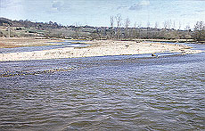 |
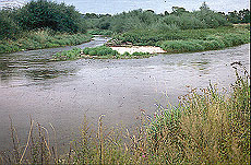 |
| Stormy bank erosion in the first years: in January 1994 (left) and in November 1995 (right) | |
Countless germ buds were recorded, but they were unable to connect to the ground
water. Nonetheless, at least seven types of willow can be found today. The least
flooded areas were covered by gravel offering good conditions to dry vegetation
such as Sedum acre and Verbascum blattaria. Ash (Fraxinus excelsior) also spread
out, which all turned the formerly agricultural land into a sight beyond recognition.
A remarkable new feature involves the diversity of the riverbed that provides
different structures for the flora and fauna to settle on. On a relatively small
site, gravel areas - previously reduced to a minimum – can now be found and
so can mud and sand areas and areas covered with water plants. Also remarkable
is the large number of young fish in the shallow water. Alongside them, large
pikes (Esox esox) have also found shelter along the banks. The restored bird diversity
is equally impressive. Birds such as the plover (Charadrius dubius) and the black
kite (Milvus milvus) hatch and feed in the area together with countless other
bird species. The area has attracted migrating birds such as several species of
swallow (Riparia riparia, Hirundo rustica, Delichon urbica), which stay there
for weeks. To the surprise and pleasure of nature conservationists, the beaver
(Castor fiber) has found the area to be a suitable home. The nearest recorded
occurrence of the beaver can be found about 50 km downstream. There are unmistakable
traces that it feeds here thus encouraging the willows to sprout.
The project area has been turned into a protected area in order to protect the
natural process of wetland re-development. Where the strongest deposits occur,
the Danube can still move more than 100 meters inland on the public ground. Humans
have reduced their activities to watching and observing.
However familiar the story of Blochinger Sandwinkel may sound, it is a reminder
that our rivers need space for their self-development. The project triggered further
wetland restoration projects such as Tuttlingen, Riedlingen and Erbach. These
local activities are small but important stepping-stones in the direction of ensuring
that "the river keeps moving”.