![]()
DoRIS: modernising Danube navigation |
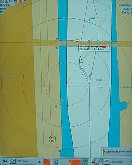 |
DoRIS locates and
displays vessels on an
electronic navigation chart
using transponders on
each vessel that
send current positions
using satellite-based
positioning technology. |
The Danube is one of the most versatile European transport routes, with a higher transport capacity than other modes. "The Danube can carry more traffic than it does now, which can reduce traffic on other transport corridors like roads," says Hans-Peter Wegscheider, Unit Manager for Traffic Management at via donau. "If we increase traffic on the Danube, however, it is important to support users and improve infrastructure and services for Danube navigation."
The project to implement river information services on the Austrian Danube, Donau River Information Services (DoRIS), is an important tool for the modernisation of Danube navigation. The DoRIS system displays vessels on an electronic inland waterway navigation chart using transponders on each vessel that send positions using satellite-based positioning technology. Once tests are completed in November the system will be in full operation on the Austrian stretch of the Danube.
"DoRIS will offer public authorities support in terms of traffic control
and traffic flow management, border control and customs clearance,"
says Wegscheider, DoRIS Project Manager. The information collected from
the system will be available to commercial users next year. DoRIS will have
important advantages for commercial waterway users; it will be possible
to track freight in real time and to continuously update transport schedules
with little effort.
For more information, please visit: www.doris.bmvit.gv.at.