Deep pool mapping and research
By Ashley S. Halls*Pilot testing of methods to estimate fish abundance and biodiversity in deep pools has yielded promising results. A full-scale survey of up to six deep pools in each country of the Lower Mekong Basin is now planned for early 2009 and a Deep Pools Atlas is being developed.
Deep pools are relatively deep areas in the river channel. Several workers, including Poulsen et al. (2002), Baran et al. (2005), and more recently Sinthavong et al. (2006) postulate that in the Mekong River system these pools provide critical refuge habitat during the dry season and possibly also critical spawning and/or nursery habitat during the wet (flood) season for many species belonging to the migratory whitefish guild. The health of this critical habitat is currently believed to be good but threatened by basin development activities, particularly hydropower dam construction, which may alter water flow and sediment transport and deny fish access to important deep pools.
Since its inception in 2000, the Technical Advisory Body for Fisheries Management (TAB) has actively promoted a greater understanding of deep pools and the " regional significance of these local habitats " to the fisheries of the Mekong. Priority action identified by the TAB during the MRC's 7th Technical Symposium on Mekong Fisheries in 2005 focused upon the identification and improved understanding of the fisheries ecology of deep pools in the basin, and thereby the appropriate fisheries management action.
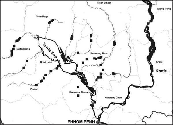
Deep pools in Cambodia
Data from Inland Fisheries Research and Development Institute,
updated 2008
Meeting the demand
In response to these research needs, and under the growing likelihood
of mainstream dam development in the Lower Mekong Basin (LMB),
the Fisheries Ecology, Valuation and Mitigation (FEVM) Component
of the MRCs Fisheries Programme, together with its four counterpart
riparian research institutes, designed a regional deep pool
research project. The two-and-a-half year project, entitled
'MRC Atlas of Deep Pools and Identification of Factors Affecting
the Quality of Deep Pool Refuge Habitat', began in June last
year. Early next year the project will publish an atlas containing
a synthesis of deep pool research and management activities
in the region together with detailed maps illustrating the location
and shape of all deep pools in the mainstream and some of its
tributaries. The maps will be annotated with summaries of available
information about each pool, including their depth, area, and
numbers of fish species and fishers. The project will also attempt
to estimate fish abundance and biomass, and to measure important
environmental variables in a sample of deep pools throughout
the length of the mainstream to improve understanding of why
some pools are more important than others as refuges for fish.
This will help basin planners and fisheries managers to predict
and map the locations of important refuges, thereby focusing
their conservation and management efforts.
Deep pool mapping underway
With colleagues from the MRC Information and Knowledge Management
Programme, the project has already compiled a deep pool database
and mapped the locations of more than 200 important deep pools
in the mainstream and tributaries of the Cambodian Great Lake
(see below). The locations of the pools were identified using
local ecological knowledge (LEK) and hydro-acoustic surveys
(see Chan et al. 2006; An
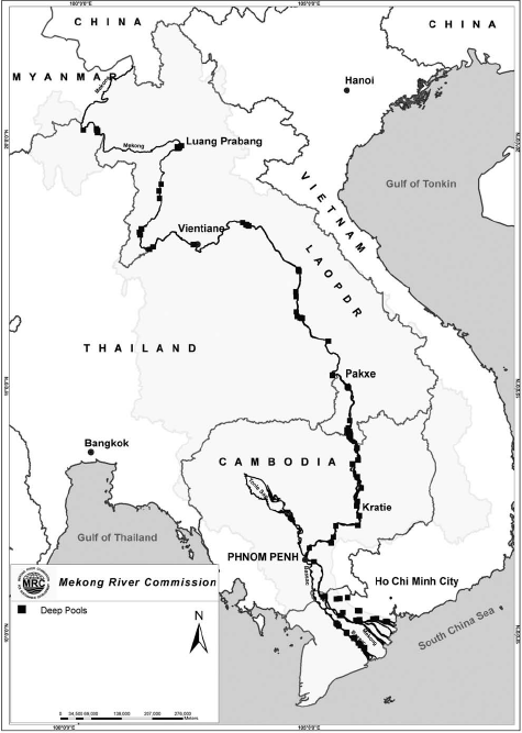
Deep pools in the Lower Mekong Basin
Data from the MRC Fisheries Programme, updated 2002
2007 and Sinthavong et al. 2006 for further details). The remaining deep pools are being identified with the support of the MRCs Environment Programme using a digital bathymetric atlas of the mainstream and the zero-crossing method (Carling & Harriet, 2000). The method has identified more than 500 deep pools in the mainstream (including those identified from the LEK surveys) from deviations in mean riverbed depth. The World Wide Fund for Nature has also offered to contribute its own research findings on deep pools in tributaries in the Lao PDR to the atlas.
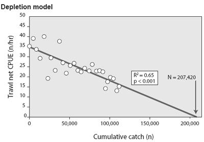
Illustration of the Leslie depletion model
used to estimate fish abundance
in the deep pools. The figure shows the model fitted to daily
trawl catch rates
(CPUE) and cumulative catch in Vam Nao pool in An Giang Province,
Viet Nam,
from March 5-31. The number of fish (N) in the pool on March
5 was estimated
to be in the order of 207,000.
Testing methods to estimate fish abundance
In March this year, the FEVM component also pilottested
depletion and hydro-acoustic methods for estimating fish abundance
and biomass in a sample of deep pools of different depths and
substrate type, in preparation for a basin-wide survey planned
for next March. The work is being undertaken by the Inland Fisheries
Research and Development Institute in Cambodia, the Living Aquatic
Resources Research Centre in the Lao PDR, the Inland Fisheries
Research and Development Bureau of the Department of Fisheries
in Thailand and Reseach Institute for Aquaculture No 2. in Viet
Nam.
The depletion method involves monitoring how catchper- unit-effort (CPUE) - an index of fish abundance - declines in response to removals (catches) of fish to estimate the original population size. The population size corresponds to the predicted removals when the catch rate (CPUE) falls to zero (see Hilborn & Walters, 1992). It requires no sophisticated technology or expertise but requires monitoring of intensive fishing over a period of time when there is no significant immigration or emigration of fish to and from the pool (closed population). The hydro-acoustic method makes the same closed population assumption, and requires technical expertise to operate expensive sonar-type equipment and to interpret the output, but can provide estimates of deep pool fish abundance and biomass in less than a day without the need to monitor any removals.
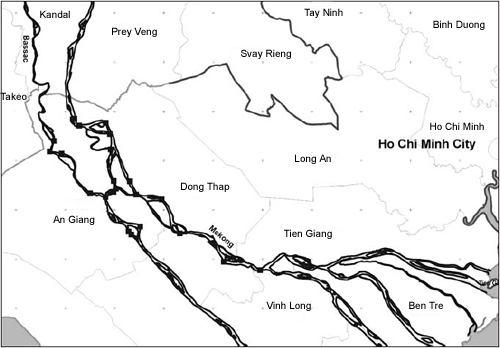
Deep pools in Viet Nam
Data from Research Institute for Aquacutlure No. 2, updated
2008
The depletion method was tested in two deep pool sites in both Cambodia and Viet Nam and in four sites in the Lao PDR where the hydro-acoustic method was also tested. For the depletion method, the pool boundaries were first demarcated, local fishers were identified and the purpose of the study explained. To encourage intensive fishing effort within the deep pools, a $100 prize was offered to the fisher who recorded the highest total (cumulative) catch during the monitoring period. For one month all removals of fish from the pools and corresponding fishing effort was recorded daily by teams of enumerators permanently stationed at each pool. In Laos hydro-acoustic surveys were also undertaken in the same pools at the start of each week. The depletion surveys in Cambodia and Viet Nam were undertaken in March when few fish are believed to migrate. The surveys in Laos were unfortunately delayed by one month.
At six of the eight deep pools selected, judging by the statistical significance of the fitted depletion models, the depletion method was found to be successful (see chart below). The remaining two pools in Laos may have also yielded reliable depletions had they been fished during the planned survey month, since the observed non-linear decline in CPUE was indicative of fish migrations through these two sites.
Fishers removed 34-87% of the fish seeking refuge in the pools representing 32-121 species of fish. Average fish size (all species combined) ranged from 36-220 g. On average the largest fish occupy pools in Cambodia while the smallest are in Laos. Biomass density estimates ranged from 48-1151 kg per ha.
Depletion and hydro-acoustic methods
The estimates of fish abundance for the depletion and hydro-acoustic
surveys were similar only for one pool in Laos (Ban Na), but
here the estimates increased by a factor of five during the
four-week survey period, despite removals of approximately only
1500 fish. The hydro-acoustic abundance estimates were more
stable through time at two sites, but at one (Don Haout) the
population estimates were almost ten times higher than the estimate
derived from the depletion method. No comparisons could be made
with the other site because of the absence of any depletion
in the population. At the remaining Lao pool (Ban Pymanpon),
the hydro-acoustic estimates of abundance declined monotonically
by more than 90% over four weeks, despite only modest removals
(about 800 fish). Therefore conclusions surrounding the accuracy
or reliability of the hydroacoustic method could not be drawn.
Findings used for survey next year
These results were discussed in detail during a second project
planning workshop held in Udon Thani, Thailand. The 15 participants
from the MRC, the four riparian research institutes and a representative
of the TAB concluded that the depletion method should be employed
for the abundance and biomass survey planned for next year.
When applied during periods when few fish are migrating and
when removals are significant (fishing is intensive), the method
appears capable of providing reliable estimates of fish abundance
and biomass. It was also recognised that unlike the hydro-acoustic
methods, it is also possible to report uncertainty (95% confidence
intervals) around the population estimates and to determine
which species form the pool population.
The workshop provided a valuable opportunity for research staff to receive training in depletion model fitting using spreadsheets and to make recommendations for improvements to next years survey, which will include more than 20 mainstream pools representing alluvial and bedrock substrate and three depth strata (shallow [<15 m], medium [15 - 35 m] and deep [ >35 m]). The survey will also measure at each pool up to 15 environmental variables that will be used to help explain variation in fish abundance and diversity among the pools, thereby facilitating conservation and management activities.
Correction
In our last issue, Catch and Culture recounted historical
descriptions of the deep-pool fishery at Ban Ang from the
first half of the 20th century ("Historic Lao fishery
for Mekong giant catfish sheds light on traditional management").
We wrote that "chanting" was said to be heard as far as Vientiane.
In fact, these historical accounts of animist rites were referring
to the sound of the cave door opening. Sorry.
* Dr Halls is the coordinator of the Fisheries Ecology, Valuation and Mitigation Component of the MRC Fisheries Programme
Further Reading
An, V.V. (2007). Deep Pools as Important Fisheries Habitats in the Mekong delta. Fisheries Ecology Valuation and Mitigation Component. Mekong River Commission, Ho Chi Min City, July 2007, 46 pages.
Carling, P.A. & Harriet, G.O. (2000). Morphology of riffle-pool sequences in the River Severn, England. Earth Surface Processes and Landforms, 25(4): 369-384.
Chan, S., Putrea, S., & Sopha, L. (2006). Using local knowledge to inventory deep pools in the Tonle Sap and Mekong Mainstream. Fisheries Ecology Valuation and Mitigation Component. Mekong River Commission, IFReDI, Phnom Penh, 17 pages.
Baran, E., Baird, I.G. & Cans, G. (2005). Fisheries Bioecology at the Khone Falls. WorldFish Center, 84 pages.
Hilborn, R. & Walters, C.J. (1992). Quantitative Fisheries Stock Assessment. Choice, Dynamics and Uncertainty. London, Chapman Hall.
Poulsen, A., Ouch, P., Sinthavong, V., Suntornratana, U., Nguyen, T.T. (2002). Deep pools as dry season fish habitats in the Mekong Basin. MRC Technical Paper No.4. Mekong River Commission, Phnom Penh, 24 pages.
Sinthavong, V., Phounsavath, S., Photitay, C., Putrea, S., Chan, S., Kolding, J., Valbo-Jorgensen, J., Phoutavong, K. (2006). Hydro-acoustic surveys of deep pools in southern Lao PDR and northern Cambodia. MRC Technical Paper No.11, Mekong River Commission, Vientiane, 76 pages.
Choose a newsletter: