SUMMARY
 The
major geological and topographic features of the Mekong River and basin
can be easily seen on the topographic maps and satellite images of Southeast
Asia. These features include the large scale physical landscapes comprised
of mountains, highlands, plateaus, deep narrow river valleys separated
by steep and very abrupt ridges, broad low lying almost featureless flood
plains and the Mekong Delta. This diversity of physical landscapes owes
its origins to the events that have taken place during a long and complex
geological history. The topographic diversity of the Mekong basin is reflected
in the diversity of ecological systems and the physical and ecological
diversity is in turn reflected in the diversity of human use of the Mekong
River basin.
The
major geological and topographic features of the Mekong River and basin
can be easily seen on the topographic maps and satellite images of Southeast
Asia. These features include the large scale physical landscapes comprised
of mountains, highlands, plateaus, deep narrow river valleys separated
by steep and very abrupt ridges, broad low lying almost featureless flood
plains and the Mekong Delta. This diversity of physical landscapes owes
its origins to the events that have taken place during a long and complex
geological history. The topographic diversity of the Mekong basin is reflected
in the diversity of ecological systems and the physical and ecological
diversity is in turn reflected in the diversity of human use of the Mekong
River basin.
The present day physical features of Southeast Asia in general and of
the Mekong basin in particular, owe their shape to the uplifting and folding
of the earth's crust that was initiated about 50 million years ago by
the collision of the Indian and Eurasian tectonic plates. From a geological
perspective, mainland Southeast Asia represents a jigsaw puzzle made up
of ancient blocks of bedrock, relatively young mountain ranges and more
recent alluvial plains. Much of the topography resulted from the Indian
subcontinent pushing under the crust of the Eurasian subcontinent. This
process that created the Himalayan mountains and the Tibetan Plateau.
Toward the south and Southeast, the enormous tectonic forces have displaced
and shifted old blocks, uplifted and folded younger geological strata
of sedimentary rock, and created depressions and lowlands that now act
as traps for collecting the sedimentation deposited during flood time
by the present day river network.
All of the tectonic activity resulted in a topographic pattern, in which
the mountain ranges resemble ribs of a fan separated by the deep trenches
carved by the Irrawaddy, Salween, Mekong, Yangzi and Red Rivers. Interspersed
within the fan-shaped pattern are plateaus at differing elevations. For
the Mekong basin, these include the Korat Plateau of Thailand and Bolovens
Plateau of Lao PDR. Topographically and in terms of elevation, the Mekong
River basin can be divided into the upper catchment, the middle reaches
and the lowlands and delta.
The source of the Mekong is located on the Tibetan Plateau, or "Roof
of the World", at approximately 5,000 meters elevation. The catchment
area of the headwaters is generally very narrow; the relief and altitude
differences exceed several thousand meters. Further downstream, the "Three
Rivers" area of the Salween, Mekong and Yangzi contains extraordinary
landforms in very rugged terrain with high, north-south trending mountain
ranges, steep slopes, and the deeply cut, closely spaced valley floors.
The upper catchment area has considerable potential for hydropower development;
some are already realized or under construction in Yunnan, China.
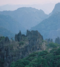
In the middle reaches of the Mekong River basin, highland and plateau
areas are most prominent, often rising above 2,000 meters in elevation.
Within the middle reaches, the Truong Son Mountains (Annamese Cordillera)
forms the topographic 'spine' of Viet Nam. The Kontum Massif, as part
of the Cordillera, contains the oldest rocks of Southeast Asia. Some of the hard,
resistant rocks form rapids and water falls in the middle and upper reaches
of the river, which has an impact on migration of some fish species and
create hazards to navigation. Among the plateau areas, the Bolovens Plateau
is the highest at about 1,500 meters and is composed of hard volcanic
rock. The Korat Plateau is the lowest at about 100 meters and largest.
It is composed of sediments and eroded bedrock. Low mountain ranges form
a distinct rim around the Korat Plateau.
The lower reaches of the Mekong include the Great Cambodian Plain and
the Delta region. These are young geological 'traps' containing the sediments
of the Mekong and those of its tributaries. The very flat and low-lying
terrain of the Plain has resulted in frequent course changes of the Mekong
over time. Annual flooding during the monsoon season occupies the floodplain,
including extensive back-swamp areas. Flooding also causes the famous
reversal of the flow of the Tonle Sap River back into the Great Lake ,
filling it like a bladder and increasing its surface area enormously while
remaining shallow.
The present delta of the Mekong is located south of the "Four Arms"
area at Phnom Penh. On its way to the sea, the various branches of the
mighty river are contained by natural embankments, or levees. These are
only partially flooded during the rainy season, in contrast to the adjacent
lowlands where numerous rice paddies cover the rich alluvial soils. Coastal
currents in the South China Sea shape the coast line and constantly redistribute
the rich sediment load of the Mekong, particularly around the southern
tip of Viet Nam.
What physical-geological impacts are going to shape the Mekong region
in the future? Lowland areas are likely going to be affected in a serious
way by salt water intrusion and sea level rise as a result of climate
change. Over long periods of geologic time, volcanic activity has been
rare throughout the highlands of the Mekong Basin, but the region will
continue to experience earthquakes resulting from the shear stress of
tectonic movements, particularly in the middle reaches of the Mekong.
On the time scales of geologic history, the enormous erosion powers of
the rivers has captured neighbouring watersheds, which has led to either
enlarging or decimating the catchment area of the Mekong.
Today although certainly not on the grand scale of geological history,
this capture and diversion of rivers can be accomplished by the technology
of dam building and water diversion schemes. Consequently, understanding
the geology and topographic features of the Mekong basin provides a foundation
for understanding the Mekong River as a physical and ecological system
and for placing the issues of river development and management into a
more realistic framework.