1.6 INTRODUCING THE GEOLOGICAL HISTORY
OF THE MEKONG BASIN
From the perspective of global tectonics, Southeast
Asia is a fascinating jigsaw puzzle. International research during the
last decades has led to the recognition that the geological backbone of
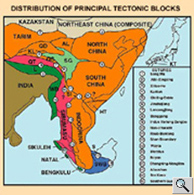
Southeast Asia consists of a series of continental fragments. Geoscientists
often refer to them as "terranes". The terranes of Southeast
Asia are all derived from the ancient continent of Gondwanaland.
Today, these pieces make up an intricate pattern of
blocks that include China, Southeast Asia, parts of the China Sea and
Burma. Recent plate tectonic theory has postulated, convincingly, that
the geological history of this area is closely linked to a sequence of
earth moving events that culminated with the collision of a considerable
chunk of Gondwana, a tectonic plate now known as India, into Eurasian
continent. This process moved ahead at a record velocity of some 6 cm
per year, causing the mountain-building process of the Himalayas and the
uplifting of a huge chunk of continental plate, now known as the Tibetan
Plateau.
Interestingly, this model of deformation of the Eurasian landmass had
been described by Argand as early as 1921. His model illustrates the thickening
of the Tibetan crust by under-thrusting of the leading portions of the
Indian continent. This remarkable section predates formal plate-tectonic
concepts by over 45 years!
The relatively recent event of
the collision of India and Eurasia has also had a pronounced effect upon
the whole region east of the impact. Simply put, the plate tectonic movements
can be replicated with a small experiment by pressing one's hand on a
tablecloth and by moving the hand slowly forward for about 30 cm. The
resulting fan-shaped folding pattern of the cloth, especially to the right
of the hand is not unlike the tectonic pattern that emerged in Southeast
Asia. It is marked by a series of the geologic faults, for example the
Red River Fault of Northern Viet Nam, and the outward arching valleys
of the principal rivers, including the Brahmaputra, Salween, Mekong, Red
River and Yangtze. In a more scientific approach, geoscientists have experimented
with plasticine models and achieved remarkable results that closely resemble
the modern tectonic map of Asia.
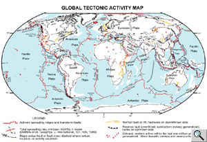
The previous maps illustrate that compression and faulting is the main
pattern of deformation, but it accounts for perhaps half of India's penetration
into Eurasia. The other half is made up of China and Southeast Asia being
pushed eastward and out of the way of India like toothpaste is squeezed
out of a tube. Those movements took place along the enormously long strike-slip
faults (see Map 4 and 5). The mountains, plateaus, faults and earthquakes
within the Mekong basin of Southeast Asia, many hundreds and even thousands
of km from the suture, are thus influenced by the continuing collision
of India and Eurasia.
In summary, the Mekong basin as a whole spans a wide range of altitude,
latitude, climate and vegetation zones along the 4,200 km length of the
river. The upper Mekong basin in China resembles a long and relatively
narrow corridor. The lower Mekong basin begins downstream of where the
river enters Lao PDR, Myanmar, Cambodia and Viet Nam. It covers 77% of
the entire basin area and account for more than four-fifths of the water
that drains the basin each year. The entire area is under the influence
of monsoon climate and thus marked by great seasonal variation in rainfall.
Typical low (May) and high (September) flow volumes of the Mekong show
a difference of the order of 15 times. This fluctuation is a defining
characteristic of the environmental conditions and has a profound impact
on resource management strategies within the basin.

