2.5 SEASONAL VARIATIONS
• Monsoon circulation is the main
agent of seasonal change
• Little variation in average temperature, but large variation in
rainfall pattern
• Modest rainfall related to disturbances from the west wind drift
during the dry season
• Climate variability and change is studied in order to better assess
their impact on the Mekong basin
• Atmospheric pollution (for example burning during the dry season)
can be a problem
 The
most important change in climate over the course of a year is associated
with rainfall. The northeast monsoon occurs roughly from November to March.
It brings relatively dry, cool air and little precipitation to the mainland.
The
most important change in climate over the course of a year is associated
with rainfall. The northeast monsoon occurs roughly from November to March.
It brings relatively dry, cool air and little precipitation to the mainland.
The southwest monsoon prevails from May to September. Then, the air current
reverses, and the dominant flow of warm and moisture laden air is to the
northeast. The basin receives up to 75% of the annual rainfall during
this period.
The dry and wet monsoons are important in explaining the seasonal distribution
of rainfall patterns. But there are other factors, for example relief,
land and sea breezes or disturbances from the west wind drift. These factors
often are combined with the monsoon circulation and can produce highly
variable rainfall patterns, even over relatively short distances. The
disturbances of the west wind drift, originating from the middle latitudes,
produce only moderate amount of rain. Other disturbances, originating
from the equatorial zone, can mature into tropical storms that bring heavy
rains and destruction to the areas over which they pass.
|
Source: National Climate Prediction Center, USA |
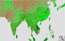
Overall there is little temperature variation
in the Mekong basin. Temperatures are steady throughout the year, averaging
between 25 and 29°C. Monthly averages tend to vary more with increasing
latitude. Increasing elevation acts to decrease average temperatures.
The greatest seasonal fluctuations are in the north, where frost may occur
in December at higher elevations. Snow falls only in extreme northern
highlands. Conversely, maritime influences moderate the climate in the
south. The cooler, drier air of the northeast monsoon produces frequent
morning fogs that generally dissipate by midday in the north and northeast
regions. Annual average sea-level temperatures are remarkably close to
27°C. The degree of seasonal variation depends upon proximity to the
sea, and also upon elevation.
Temperature distribution over Southeast Asia during the months of January, April, July and October (average of 1961-1990) Source: National Climate Prediction Center, USA |
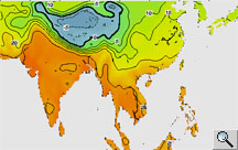
The issue of variation in the climate of
the Mekong Basin and the potential effects of climate change on the region
are currently under study. For example, with the help of satellite derived
information, researchers can map monthly differences or changes in precipitation
patterns against the long-term average. Exceptional floods occurred within
the Mekong Basin in the year 2000. An example of the rainfall anomalies
recorded during that year is given in Jan / April / July / Dec. This series
of maps reveals abnormally high precipitation over many regions of the
Mekong Basin; high concentrations are noted throughout the year, particularly
in its lower portions.
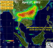
Other satellite instruments are capable to detect pollutants in the atmosphere.
In April 2002, Total Ozone Measurement Spectrometer (TOMS) provided some
imagery of abnormally high concentrations of pollutants. Smoke from biomass
burning in Southeast Asia seemed to be severe toward the end of the dry
season as shown on imagery on April 7, 11, 13, 2002.
|
Source: NASA/TOMS and Goddard Scientific Visualization Studio |