5. The 2008 flood season
5.2 Meteorological conditions
From a meteorological perspective, conditions within the annual Mekong flood season should be assessed with respect to two aspects:
- The intensity of the SW monsoon in terms of cumulative rainfall and the creation of saturated soil moisture conditions which maximise flood runoff. In some years it is this effect combined with a strong Monsoon which generates exceptional volumes of floodwater and extremely damaging levels of flood inundation. This was the case in 2000, particularly across the Cambodian flood plain and the Delta in Viet Nam.
- The incursion of tropical cyclones and tropical storms into the basin which historically, given already saturated catchments, have produced most of the highest observed water levels and flood discharges. The events of 2008 are a case in point.
The timing of the regional onset and end of the SW Monsoon is remarkably consistent from year to year, with a typical standard deviation of only one to two weeks. The data for the locations indicated in Table 5.1 are based upon criteria applied in India by Khademul et al. (2006). The annual onset of the SW Monsoon may be defined as the week during which more than 20 mm of rainfall occurs within 1 or 2 consecutive days, provided that the probability of at least 10 mm of rainfall occurring in the subsequent week is more than 70%. The latter component of the criterion screens out isolated storm events earlier in the year that do not fully indicate the start of ‘true’ monsoonal conditions. The date of monsoon withdrawal is defined as the day up to which at least 30 mm of rainfall accumulates over a sequential seven day period, with no subsequent rainfall for at least 3 consecutive weeks.
| Site | Monsoon onset | Monsoon withdrawal | ||||
| Average Date | Standard Deviation | 2008 | Average Date | Standard Deviation | 2008 | |
| Chiang Saen | 7th May | 9 days | 3rd May | 7th Nov | 25 days | 14th Oct |
| Luang Prabang | 7th May | 9 days | 28th April | 24th Oct | 33 days | 3rd Nov |
| Vientiane |
4th May |
8 days |
27th April |
10th Oct |
16 days |
3rd Nov |
| Pakse |
5th May |
11 days |
28th April |
15th Oct |
17 days | 3rd Nov |
| Tan Chau |
11th May |
7 days |
7th May |
17th Nov |
14 days |
26th Nov |
The onset of the Monsoon typically occurs within a remarkably narrow period of time in May. It withdraws usually during October in the more central areas of the Basin and in November in the north (Chiang Saen) and south (Tan Chau) where there tend to be wider variability from year to year. During 2008 the onset and end dates were within the characteristic range. The early withdrawal of the Monsoon, as happened in 2004 when the rains ceased a month earlier than usual can precipitate serious drought conditions due to depleted soil moisture for crops that rely on late seasonal rainfall.
From a temporal perspective therefore, Monsoonal conditions during 2008 appear to have been typical across the region. In terms of total seasonal rainfall the general picture is one of an average year (Figure 5.2), though with the expected significant exceptions1. However, drawing basin wide conclusions from such a small sample of data could be misleading, particularly when the spatial variation of rainfall is high, even at the local scale. Nonetheless the indications are that:
- Total annual rainfall at Chiang Saen, Luang Prabang, Chaing Khan and Tan Chau were average and over the year as a whole accumulated according to a typical pattern;
- At Vientiane, the total rainfall for 2008 of 2,200 mm would define the year as extremely wet, while;
- At Pakse the annual total was significantly below normal.
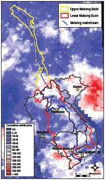
The definitive meteorological event of 2008 was the incursion into the northern regions of the Basin of tropical cyclone Kammuri during the first week of August which produced extreme water levels and volumes of runoff in the Mekong mainstream, particularly at Luang Prabang and Vientiane. However, the rainfalls observed in August at those sites in the north for which data are available, namely Chiang Saen, Luang Prabang, Chiang Khan and Vientiane do not reflect the extreme levels of precipitation that must have occurred in the wider northern sub region. This reflects the fact that the regional rain gauge network is most sparse in those remote areas that receive the highest rainfall on average and which generate the major volumes of flood runoff.
The track of cyclone Kamurri is shown in Figure 5.3 and the associated storm rainfall, based upon satellite imagery, shown in Figure 5.4:
- In the Lao PDR most rainfall occurred upstream of Luang Prabang. Accumulated rainfall over the nine days between the 6th and 14th of August was generally between 100 and 150 mm, though locally the figures were as high as 200 – 250 mm.
- In Yunnan the cumulative rainfall was similar and generally confined the extreme south, downstream of Jinghong.
These areas therefore generated virtually all of the consequent flood runoff, while elsewhere in the Basin the rainfall was much more scattered and not directly linked to Kammuri.
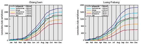
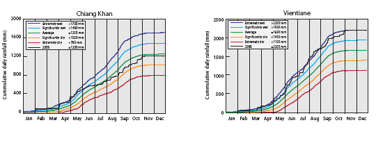
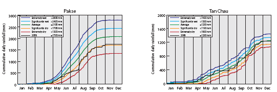
Figure 5.2: Cumulative
annual rainfall during 2008 at selected sites in the Lower
Mekong Basin.
(Extremely wet and dry conditions are defined as plus/minus
2 SD, and significantly wet and dry
as plus/minus 1 SD.)
Although as expected regional catchments were all saturated at this stage of the flood season (Figure 5.5) which would have enhanced the levels of storm runoff, the extend and magnitude of the rainfalls indicated in Figure 5.4 appear to be modest compared to the volumes of flood runoff that were subsequently generated. This observation may be seen as supporting the emerging view that the satellite data do indeed underestimate regional storm rainfall which makes accurate flood forecasting more difficult. There is therefore a need for improved ‘ground truthing’ of satellite based estimates of storm rainfall and in particular the expansion of the sparse rainfall observation network in northern and eastern Lao PDR.
 |
|
 |
|
| Figure 5.3: Track of tropical storm Kammuri – first week of August, 2008. (Map based upon data obtained from the Hong Kong Meteorological Bureau http://weather.gov.hk.) | Figure 5.4: Accumulated rainfall over the Mekong Region: 6th to 14th August 2008. (Based on data provided on a daily basis by the United States National Oceanic and Atmospheric Administration to the MRC). |
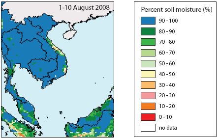
Figure 5.5 Regional soil moisture conditions
during early August 2008, indicating
that catchments were saturated. This would have maximised
the flood runoff that
resulted from tropical storm Kammuri.
(Source: USDA, http://gcmd.
nasa.gov/records/ GCMD_USDA _FAS_ Percent_Soil _Moisture.html.)
______________
1 Sufficient data for the year of interest, in this case 2008, in order to produce a basin-wide map of the seasonal rainfall were not available in time for this report., while issues of data quality arose for those records that were received, such that only a few could be used with confidence,
Choose a newsletter: