2. Flood benefits
2.1 Introduction and historical context
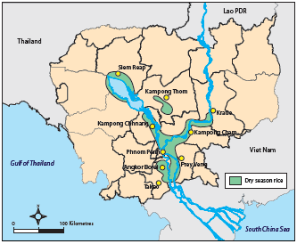
Figure 2.1: The distribution
of flood recession rice cultivation
areas and pre-Khmer archaeological sites in Cambodia.
(Source: Fox and Wood, 1999)
Conventionally, floods and flooding are perceived as geophysical hazards within a common framework of natural disasters that also covers storms and hurricanes, earthquakes, volcanic eruptions, landslides and tsunami. In each case, socio-economic losses and damage increase exponentially with event magnitude and as a function of civil exposure and vulnerability. Such hazards are perceived as random events that have entirely negative impacts, ignoring the fact that floods also have a positive ecological and socio-economic function. Great civilizations have developed within flood plains where, on the face of it, exposure and vulnerability have been high. Such societies have included Sumerian Mesopotamia along the Lower Tigris and Euphrates Rivers, ancient Egypt along the Nile, the Harappan culture of the Indus valley in Pakisan and India, the founding cultures of China in the Yellow River Valley and the Angkor civilization of the Lower Mekong Basin itself. Exploiting the benefits and avoiding the risks brought by the annual flood stimulated such societies to put greater efforts into social organization and water management systems, which endorsed them as landmark civilizations.
Historically cultures that exploited the benefits of floodplains and contemporary societies which continue to do so, such as those in the Lower Mekong, have to face a two-tailed flood hazard (Webby et al., 2007). Either the annual flood is too small, leading to reduced agricultural output or too large, resulting in inundation, crop losses and general socio-economic damage. The dis-benefits arising from the 'failure' of the flood season must not therefore be ignored or even made light of. As will be seen, historically some of these deficiencies in the flood season hydrology of the Mekong have been quite spectacular.

Figure 2.2: This bas relief
at Angkor Wat is indicative of the
importance of fish in the socioeconomics and culture of the
Khmer Empire (800 – 1300 AD)
The Mekong Delta and Cambodian floodplain are the site of one of the earliest civilizations in mainland Southeast Asia. Called Funan by visiting Chinese dignitaries, by the 3rd Century AD it was centred around two major urban centres, namely Oc Eo in Viet Nam and Angkor Borei in Cambodia (Jacques, 1979). It has been argued that dry season flood recession rice cultivation formed the agricultural basis of Angkor Borei and may have dictated the location of the city itself (Fox and Wood, 1999). The link between the rich agricultural possibilities provided by the annual Mekong flood and the genesis of such pre-Angkor civilizations is clear from (Figure 2.1) which compares the location of 2nd and 3rd Century archaeological sites with the flood recession rice growing areas (see Fox and Wood, 1999). It is entirely likely that this farming system became the future basis for later Lower Mekong civilizations such as that of Angkor itself which has its classic period between 800 and 1300 AD. Angkor eventually evolved into a true ‘hydraulic civilization’ organised around the need to manage water through a vast system of irrigation canals.
The ability to maintain soil fertility over time has been a major challenge to Asian civilizations. The Chinese, for example, developed a sustainable agricultural system based on meticulous schemes for recycling organic waste; agriculture in Japan, Java and the Philippines was based on rich volcanic ash soils (Ng, 1979). In Cambodia most soils are not naturally fertile (Delvert, 1961) but farmers recognised over 1800 years ago that, being located within a flood plain and deltaic system that allowed rising floodwater to spread out across the landscape and deposit millions of tonnes of fertile sediment annually, they could develop a highly productive and sustainable system of agriculture. The enhanced crop yields achievable from flood recession agriculture are clear from the figures in (Table 2.1).
| Land use system | Yield (tonnes per hectare) |
| Rain-fed paddy rice – wet season | 1.6 |
| Flood recession rice cultivation – dry season | 3.0 |
These benign effects of the annual Mekong flood with their attendant benefits extend to the regional fishery which is an imperative component of the basin’s economy. The first records of the importance of fish and fishing is provided by the Bas Reliefs in the temples of Angkor, dating from the 11th Century (Fox and Wood, 1999). Fish are represented in daily activities in markets and also appear in agricultural scenes pointing perhaps to early aquaculture. Accounts provided by Chinese travellers over 700 years ago indicate that fishing practises and the economic importance of the Mekong fishery have changed little. The next accounts of capture fisheries come from French and English travellers in Indo China and Thailand during the late 1800s. They identified the important areas as the Great Lake in Cambodia, the Mekong mainstream to Khone Falls, and the surrounds of Vientiane and Luang Prabang.
Over this period, the Mekong fishery developed to take advantage of annual fish migrations at the beginning and end of the flood season. The annual mono-modal flood pulse of large tropical rivers such as the Amazon, Congo and Mekong is the dominant ‘trigger’ in the annual cycle of ecological processes within the fluvial system, bringing about a distinct seasonality in the annual hydro-biological cycle between an aquatic phase and a terrestrial phase (Junk et al. 1989). As a consequence there are highly seasonal bio-geochemical cycles, growth rhythms and life cycles amongst the many species of ecosystem system biota such as algae, macrophytes, trees, fish and invertebrates (Junk, 1997; Junk et al., 2000; Junk and Wantzen, 2004) and these have been exploited much to the benefit of the riparian societies.
This pivotal role that the annual Mekong flood has played in the evolution of the cultures and economy of the basin therefore negates the concept of a flood exclusively as a (usually) disastrous overflowing of water onto previously dry areas. In a hydrological, ecological, economic and social environment such as that which prevails in the Lower Mekong Basin the annual flood only becomes a hazard if certain hydrological benchmarks are exceeded. Although important, it would be incorrect to define these thresholds simply in terms of water level or the associated discharge since these variables only describe one aspect of what is a multivariate random process. The annual flood in the Mekong arises from the complex interaction between meteorological conditions and the basin response which generates a seasonal hydrograph which needs to be defined in much wider terms.
The weight of the evidence, both historical and contemporary, suggests that the benefits of the annual Mekong flood far outweigh the costs in most years. The balance between the two is not static, however. When critical hydrological thresholds are exceeded the value at risk is increasing annually since there is rapidly accelerating development within the flood plain, its population is increasing and the crops, property and inventory at risk are becoming more valuable. Such circumstances are in common with those world wide where there appears tobe a systematic growth in the exposure and vulnerability of society to flooding, particularly in developing countries, such that annual costs and losses are growing even though there is little evidence (so far) to suggest that the incidence and severity of the events themselves is on the increase.
The economic dimension as to whether there is an overall regional cost or benefit accruing to the annual flood in any given year is complex and fuzzy. The very size of the Lower Mekong Basin is such that the synoptic events which cause extreme runoff have an area of impact that can only cover a part of the region, such are the consequences of scale. While the strength of the SW Monsoon defines the overall character of the flood season it is typhoons and tropical storms that typically generate the extremes and most damaging events. Historically, there have been no flood seasons during which the whole basin has been affected by critical conditions. Hence there can be considerable geographical variation across the region in the annual flood situation, a fact emphasised during the events of 2008 (details in Chapter 6).
The picture that clearly emerges is that the annual flood has been pivotal to the cultural and socioeconomic evolution of the Mekong region and that despite the fact that some loss and damage occurs in most years, those that are significant at the regional and national scales have a frequency that is low enough to ensure that over time flood benefits exceed the flood costs by a considerable margin. Arguably therefore, the logical approach is to set out the benefits first and then consider the losses, which helps to moderate the perspective of floods as an entirely negative process. This is not to underplay the importance of the need to develop strategies to manage and mitigate flood losses and damage. In some years they can be catastrophic to the extent of causing a significant fall in GDP.
Choose a newsletter: