3. Flood benefits
3.3 The regional history and pattern of flood damage
For the Lower Mekong Basin as a whole history reveals that some order of flood damage occurs in almost every year on a scale which varies between that caused by local flash flooding to that arising from large scale regional events, often classified as natural disasters, such as the flood of 2000 and to a lesser extent that of 2008. Even though annual damage data have been systematically collected for quite a number of years assembling them into a coherent series on the basis of which, for example, trends in regional flood losses could be reliably evaluated is difficult. The historical figures have to be adjusted to net present value, damage and loss surveys are improving constantly, the value of the property and inventory at risk is increasing, the improved levels and therefore the financial costs of emergency response are growing and as the regional socio-economy and services provision develops the order of secondary damage is increasing year by year as a proportion of total damage.
Figure 3.5 to Figure 3.8 show the annual flood damage for each of the four riparian countries over the years for which data are available.
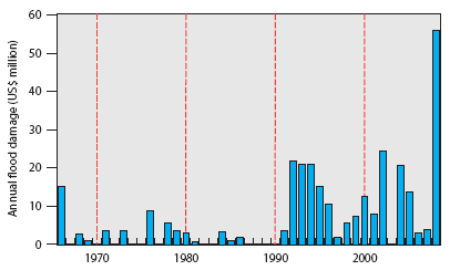
Figure 3.5: Lao PDR, annual
flood damage 1966 2008.
(Sources: www.internationalfloodnetwork.org and Lao National
Flood Report, 2008.)
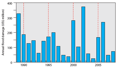
Figure 3.6: Thai Mekong
region, annual flood damage 1989 2008.
(Sources: Thai Disaster Mitigation Centre, Department of Disaster
Prevention
and Mitigation and Ministry of Interior.)
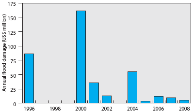
Figure 3.7: Cambodia,
annual flood damage 1996 2008.
(Source: Cambodian National Committee for Disaster Management.)
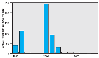
Figure 3.8: Mekong Delta,
Viet Nam, annual flood damage 1995 2008.
(Sources CCFSC, MARD and MONRE)
- Although data for Lao PDR are available since 1966 it is unlikely that those prior to 1990 are particularly reliable. There is certainly a break in their pattern and magnitude at this point. Since 1990 the average annual flood costs have been of the order of US$10 million. The cost of the 2008 event are estimated to be US$55 million, by far the largest over the period and far larger than those of 1966 when the central business districts of Vientiane were flooded. If these 1966 figures were adjusted to contemporary values they would probably be at least comparable to or possibly exceed those of 2008.
- The data for the Thai Mekong region from 1989 onwards indicate an average annual flood damage figure of US$16 million. The fact that significant flood damage occurs almost every year reflects the perennial incidence of flash floods in the northern provinces around Chiang Rai and the fact that considerable areas of the low lying Mun – Chi Basin are inundated annually to some extent.
- In Cambodia and the delta in Viet Nam the financial losses related to the 2000 event is the dominant feature in the recent history of flood damage. Though average annual losses are difficult to assess from the available data, as a tentative estimate a figure of US$25 million is adopted for both.
These figures translate into an annual average total figure for regional flood damage of US$76 million, close to the figure for 2004 which may be considered to be an average flood year. The figure is distributed as indicated in Figure 3.9.
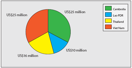
Figure 3.9: Indicative
distribution of average annual regional flood costs of
US$76 million.
The picture changes if the figures are expressed as a proportion of regional GDP (the total annual value of all goods and services produced) in that part of each country that lies within the Lower Mekong Basin (Table 3.1).
On this basis the average annual flood damage inflicted on the national economies is highest in Cambodia and Lao PDR, the least developed countries. This would appear to confirm the widely held view that the proportional economic losses to natural hazards such as floods is greater in poorer societies which are more vulnerable.
| Country | National
GDP (US$ billion) |
Lower
Mekong Basin GDP (US$ billion) |
Average
annual flood damage as a proportion of National GDP generated in the Lower Mekong Basin |
| Cambodia |
8.7 |
8.0 |
0.29% |
| Lao PDR | 4.0 |
4.0 |
0.25% |
| Thailand | 246.0 |
22.0 |
0.07% |
| Viet Nam | 85.0 |
25.5 |
0.09% |
| Total LMB |
60.2 |
Losses as a proportion of GDP under extreme flood conditions obviously cause even greater economic damage, the benchmark measure for which in recent times were the events of 2000 which were centred on the southern areas of the basin in Thailand, Cambodia and Viet Nam. Total damage was estimated to be US$695.5 million, or 1.34% of regional GDP. The flood of 2008 was less extensive, confined to the northern parts of the basin and generated far less damage in value terms. Never the less the costs to Lao PDR of US$56 million amounted to 1.4% of GDP.
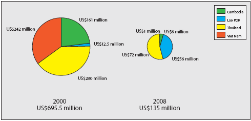
Figure 3.10: Mekong floods
in 2000 and 2008 – proportional and total damage.
Although the major flood events of recent history and the associated losses are linked to extreme flows on the Mekong mainstream it would be wrong to suggest that they have exclusively determined the historical pattern of annual flood damage. Throughout the region annual damage is linked to a diversity of flood conditions and cannot be related to a single regional hydrological or meteorological index as Figure 3.11 confirms. The annual cost of flood damage in Lao PDR is clearly not simply a function of the magnitude of the Mekong flood expressed in terms of peak discharge, though the exceptional mainstream peak flows and water levels of 2002 and 2008 did account for the largest losses in recent decades. During other years, however, the national costs of flood damage are independent of hydrological conditions in the Mekong mainstream and might arise from local tributary floods, upland flash flooding or simply an accumulation of damage during a strong SW Monsoon when a larger than average number of severe tropical storms might occur.
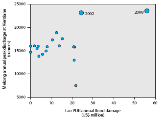
Figure 3.11: Scatter plot
of the 'relationship' between annual
maximum discharge on the Mekong at Vientiane and the
reported annual flood damage in Lao PDR over the years
from 1990 to 2008.
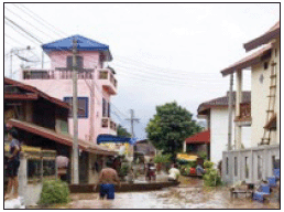
Figure 3.12: Urban flooding
– Vientiane, Lao PDR, August 2008.
Even in Cambodia and the Delta where annual flood damage would be expected to be more directly linked to flow conditions on the mainstream there is no single hydrological measure that can be systematically linked to the losses (Figure 3.13). Factors other than peak and volume play an important role such as the duration of water levels above critical thresholds and the time of the year that crops are submerged.
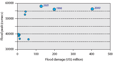
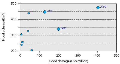
Figure 3.13: Total annual
flood damage (1996 2008) in Cambodia and
the delta in Viet Nam in relation to the peak and volume of
the annual
flood hydrograph recorded at Kratie.
Choose a newsletter: