6. Summary of the 2008 country reports
6.3 Thailand
General situation
Two major events dominated the flood situation in the Mekong region of Thailand during 2008:
- The consequences of cyclone Kammuri during August and the resultant extremely high water levels in the Mekong mainstream which caused over bank flooding over considerable areas in Nan, Chiang Rai, Nakhon Phanom, Sakon Nakhon, Nong Khai, Mukdahan, and Phetchabun provinces.
- Extreme storm rainfalls caused by tropical storm Mekkhala between September 30th and 1st October. Flooding was widespread nationally but the Mekong region was affected particularly Khon Kaen and Loei provinces and the Mun Chi Basin. Earlier during the first two weeks of September at Khon Kaen more than 50 mm was recorded on most days, with more than 125 mm observed on the 13th, 16th, and 17th of the month causing severe local disruption and damage.
Tropical storm Noul passes over the southern regions of Thailand during November and caused significant losses and damage but not within the Mekong region.
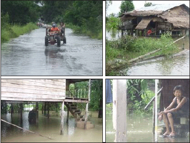
Figure 6.6: Flooding in Nakhon Phanom
Province in mid August.
Over the NE of the country the regional rainfall for the 2008 monsoon season is estimated to have been 1,650 mm, about 20% above average – largely explained by higher than normal rainfall in between September and November. However, there was considerable geographical variation caused by quite local synoptic conditions that resulted in exceptional storms over several days or weeks, such as those that were confined to Khon Khaen Province during early September. No instances of serious flash flooding were reported from the north of the country, in Chiang Rai Province for example. The tends to confirm the observation made elsewhere that the extreme rainfall associated with cyclone Kammuri that caused the Mekong flood conditions of mid August were largely confined to within the northern regions of Lao PDR.
At the national level1 the total financial losses for 2008 flooding amounted to 75% of the average figure over the six years from 2003 to 2008. Of the 2008 losses some 40% was ascribed to the impacts of tropical storm Noul over the southern regions of the country outside of the Mekong Basin.
The Mekong floods of August
As on the left bank of the Mekong in Lao PDR, flood inundation due to extreme mainstream water levels in mid August on the right bank in Thailand was mainly in semi urban and rural areas that did not have the benefit of flood protection levees. Where these were present, in Nong Khai for example, the central urban districts suffered only minor flooding and disruption. However, even here, as in Vientiane, sand bags were strategically placed to manage the risk. In all 7 provinces and over 2,300 villages were affected in Thailand, not only those directly adjacent to the Mekong mainstream but also those along the tributary rivers such as the Nam Loei and Nam Songkhram. As in all years when water levels in the mainstream reach their peak there are tributary backwater effects which can extend far upstream such that inundation extends over wide areas beyond those immediately adjacent to the Mekong.
Intense local storms during early August intensified the impacts of the over bank Mekong flooding. For example, at Nakhon Phanom on the 11th 270 mm was recorded and almost 150 mm at Nong Khai on the same day. This combination of events resulted in six deaths.
Flooding in Khon Kaen province – September
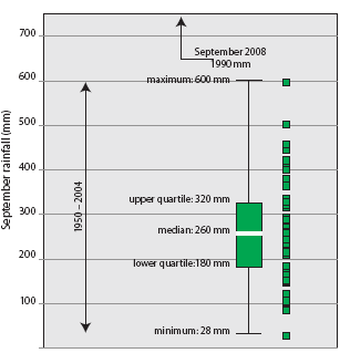
Figure 6.7: Khon Kaen
The sample distribution of
September rainfall over the 55 years from 1950 to 2004
compared to the reported 2008 monthly figure of 1,990 mm.
If the figures are correct the total rainfall for September 2008 at Khon Kaen was 1,990 mm, which compared to the available historical records over the 55 years between 1950 and 2004:
- Is more than 1.5 times the mean annual rainfall of 1,250 mm;
- Is higher than the highest recorded annual rainfall of 1,850 mm observed in 2000;
- Is more than seven times the average September rainfall of 260 mm;
- Is more than three times the highest recorded September figure of 600 mm observed in 1982 (Figure 6.7).
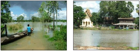
Figure 6.8: Flooding in Khon Kaen Province
as a result of unprecedented September
rainfall.
If this is indeed the case then rainfall conditions at Khon Kaen during September 2008 were unprecedented by some considerable margin.
The consequent flooding extended over 23 provincial districts to a mean depth of 0.3 m. Two people were reported to have died.
Flood damage and losses
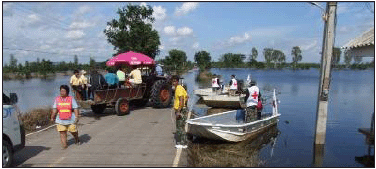
Figure 6.9: Emergency medical provision
– Lop Buri Province.
September 2008.
The total national figure for flood losses in Thailand during 2008 has been estimated to be US$72 million, of which US$28 million occurred in the far south of the country during the passage of tropical storm Noul. This flooding in the south and that in the western provinces during October would appear to account for the greater part of the national damage. Although substantially higher than those of 2007, the 2008 figures are much less than the average over recent years and less than half of those of 2005 and 2006.
The damage in the Thai Mekong region was generally confined to rural areas and the agricultural sector and although the water levels in the Mekong were the highest for almost 50 years their impact in terms of monetary loss appears to have been modest compared to events elsewhere in the country during 2008.
Lessons learnt
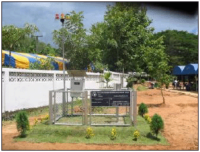
Figure 6.10: A component of the flash
flood and
landslide monitoring network.
As in any emergency response activity coordination between the various agencies responsible is key to effective implementation. In Thailand a comparatively wide range of organizations provide aid such as the Rajaprajanugroh Foundation Under Royal Patronage, the Thai Red Cross Society, the Department of Disaster Prevention and Mitigation, National, Provincial and District Authorities, the Royal Irrigation Department, the army, the Department of Water Resources and so on. A need is recognized for improved planning and coordination between these bodies at the community, basin and national level.
The government's National Policy statement on Land, Natural Resources and the Environment of December 2008 heeds the lessons of recent national disasters and calls for a greater emphasis upon preventive measures, such as early warning systems and the use of geo-informatics to identify and monitor areas at risk. Amongst the approved measures is the installation of an early warning system for flash flood and landslide risk which will cover 2,300 villages by 2012, the establishment of the ‘Mekhala Centre’ for water crisis management which will exploit modern IT technology and Decision Support Tools and improved flood warning in the Mun Chi Basin based on an expanded telemetry system.
___________
1 Flood damage data
at the provincial level such that a figure could be obtained
for the Thai Mekong region were not made available.
Choose a newsletter: