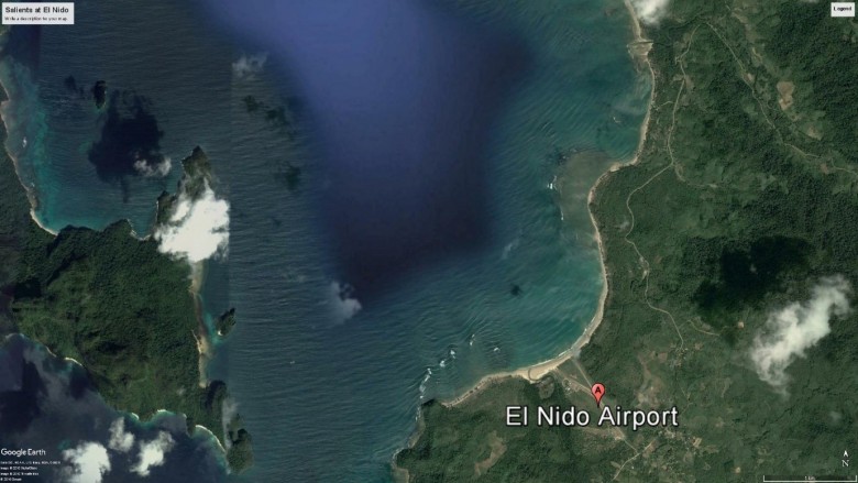
Google Earth image showing reefs at El Nido, Philippines. Locations A and B indicate shoreline bulges (salients) formed behind nearshore reefs. The shoreline would probably re-align if these reefs were lost, leading to large erosion of the shore at locations A and B. (credit: Google Earth)
Understanding reefs’ role in coastal defence
March 22 2017
Protecting shorelines is a service provided by coral reefs - safeguarding communities, livelihoods and coastal infrastructure across the East Asia-Pacific.
CCRES researchers from The University of Queensland’s Coastal Engineering Group are developing tools to demonstrate the role that reefs play in protecting shorelines and what might happen to those shorelines if reefs are damaged or sea levels rise. This knowledge can inform coastal management and planning decisions.
The work of the team of Professor Tom Baldock, Dr David Callaghan and Dr Behnam Shabani to date has involved wave modelling at both the El Nido and Selayar pilot sites. They have also looked at the geomorphology (size and shape) of a range of coral reefs, and developed a model to predict the degree of protection given to beaches by these reefs using parameters such as reef geometry, reef health, reef-bay configuration and wave height.
The team is now creating a web-based tool to illustrate what is likely to happen to the shoreline behind a reef when various factors in the environment change. Users of the tool will be able to easily and rapidly estimate the effectiveness of local reefs as a defence against waves and storm surges, without the need to understand complex models or access engineering expertise.
Users will enter parameters describing the reef (e.g. width, length, depth of the reef flat, wave height, lagoon depth), and then change these parameters to create a new scenario for that reef. Comparing the two scenarios will show users the impact of the changed conditions. For example, if the measure for reef crest depth were lowered from 1 metre to 1.5 metres to simulate sea level rise or loss of coral through degradation, the tool will demonstrate the extent of the coastal erosion that can be expected in a particular location with sea rise.
Users will be also able to predict wave induced flow velocity and wave height on the reef flat under different scenarios. The wave induced flow velocity is important in terms of the degree of turbidity, which can damage reef health, but is also important in delivering nutrients and mixing. Increased wave height can create unsafe conditions for fishers or tourism activities or lead to breakage of coral.
The tool can also be used to predict the impact of a change in reef structure from practices such as bombing that alter the shape and roughness of a reef.
The team also hopes to develop a communications tool for use at the community level to demonstrate the vital role reefs play in coastal protection. This may help to discourage destructive practices and encourage the conservation of reefs.
For more information, contact Prof Tom Baldock