![]()
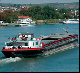 |
The Danube with its 2.780 km is
navigable from Kehlheim
(Germany) over 2.411 km all the way down to Sulina
(Romania) at the Black Sea. |
A festive mood persisted this spring, although it was enjoyed by only a
handful of people, mostly those in the shipping industry. This spring, the
Austrian administration succeeded in Brussels in declaring 45 kilometres
of the Danube east of Vienna a priority in the EU plan for a Trans-European
Network for Transport (TEN-T).
The plan for the Danube, as part of the TEN-T project, is to deepen the
river to improve inland waterway navigation. The areas along the Danube
that would be affected include the wetlands between Vienna and Bratislava,
The Danube National Park in Austria, The Danube-Drava National Park in Hungary,
and valuable intact stretches along the lower Danube between Bulgaria and
Romania.
Where to draw the line
Ecologists in opposition to the plan suggest only repairing the riverbed
with a layer of stones. Ship captains, however, would like to see the river
deeper. Instead of the current depth of 2.2 to 2.5 metres, they suggest
2.8 metres. This depth is necessary, they say, because of the stones planned
to repair the riverbed. The stones will withstand the current’s power,
but they will make shipping risky business, say captains, as ships’
propellers could screw into the ground and cause damage.
"We need a safety margin of 30 centimetres,” said Helmut Kukacka,
Austrian Secretary of State for Transport, suggesting 2.8 metres. Kukacka,
under pressure from the container-shipping lobby, said that as the project
will cost EUR 200 million, "there must be a benefit for the shipping
industry.”
Bernd Lötsch, a scientist seen by many as the country’s ecological
conscience, disagreed. He said the plan was, "not needed by national
economy or by nature”. According to Lötsch, if the river is deepened
to 2.5 metres, already a "tremendous step forward”, some 600,000
cubic metres of soil will have to be moved. "If there will be a depth
of 2.7 metres some 1.2 million cubic metres will be moved.”
Keeping nature in mind
Christian Schramm, Via Donau project manager for the Integrated River Engineering
Project on the Danube, said that the TEN-T project would be, "good,
not just for shipping or navigation, but will have very high ecological
benefits as well”. He said that a large part of the project money
would be spent on the ecological needs of the area, especially for the Donau-Auen
National Park. According to Schramm, much of the work will improve the national
park. "Currently, there is a very low water level in the park and the
project intends to bring more water to the park, among other benefits,”
Schramm said.
Ripple effect
The World Wide Fund for Nature (WWF), which owns land in the flood plains
and has legal rights in these actions, is taking an active interest in the
proceedings. "The biggest impact is the signal abroad,” said
Ulrich Eichelmann, expert for rivers in the Austrian branch of WWF. "The
Danube Convention suggests for this part of the river an optimal depth of
2.5 metres. If the Danube will be deeper here, shipping industry in other
parts will urge for the same, they all will demand 2.7 or 2.8 metres. It’s
a prejudice.”
Currently work is still in the planning stages for environmental impact
surveys, but a 3 kilometre pilot project could begin as early as next year.
The deep questions will have to be answered when work begins on the project
in summer 2006.