Powerful models bring planning tools to the basin
The Lower Mekong Basin is home to around 60 million people, but within the next 20 years this number is expected to rise to at least 80 million, if not more, and this will put the basin's natural resources under increasing pressure.
The majority of the population of the Lower Mekong Basin is still highly dependent on an agricultural lifestyle and remains relatively poor. If the region is to achieve its goal of alleviating poverty and improving its economic well being, the riparian governments know that they must find ways of developing its natural wealth.
The good news is that the region has huge water resources which could be developed in a sustainable manner, not only to allow the current population to improve their standard of living, but also to cope with the predicted population upsurge. Current levels of water use and regulation in the LMB are very low compared to most other large rivers in the world, for example, irrigation diversion accounts for less than 10% of the total water available and most tributaries in the LMB remain unregulated.
Equally, all countries depend on the natural river flows on which both the environment and people depend. Consequently, the principles of Integrated Water Resources Management (IWRM) need to be applied to basin development planning to consider impacts not only for the intended sector and country, but across all sectors and countries.
Development without due consideration of impacts on the environment is not in the MRC equation, so careful planning is essential prior to action. Development sectors that most impact water resources are:
- Hydropower, which will redistribute water from the wet season to the dry season; and
- Irrigation, which will divert large volumes of water from the Mekong River and tributaries in both the wet and dry seasons.
This is where the expertise of the Mekong River Commission Secretariat comes to the fore. The MRC's Technical Support Division, with the assistance of the British consulting group Halcrow, has developed a software suite of powerful modelling tools called the Decision Support Framework (DSF), which enables them to ascertain how much development can be undertaken before there is any significant effect on the water flows. These calculations are backed up with a huge amount of data gathered from across the basin, including China.
The data includes a vast range of input from the MRC's four member countries through the National Mekong Committees and the relevant line agencies, with the most detailed data coming from the area stretching from Chiang Saen in Thailand down to the delta region in Viet Nam. The data is updated regularly.
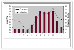
The database includes statistics on terrain elevation; land use; land cover; river tributaries and watersheds; crops planted; physical data such as river cross sections; rainfall; evaporation, temperature, discharges and water levels. Using this data the modellers can forecast what will happen if the basin's environment is altered in any way and they can produce many varied results.
Building the original database and modelling system was a huge task. Halcrow developed the base model and finished in 2004. Since then the data have been updated and the models have been refined.
There are three main models:
- The hydrologic model is used to measure how much water is coming into the river and includes run off from the watersheds and tributaries. The model enables modellers to look at different land uses, climate changes, development and what impacts these would have on the hydrological regime.
- The water management model tracks water needs for irrigation or power. It can report if there will be enough water at certain times of the year for a region's needs and how distribution of water changes during the year. One important use of the model is to demonstrate the impact of new man-made structures, such as dams, on the flow regime.
- The hydraulic model concentrates on the flood plains in the Lower Mekong and delta area as well as the Tonle Sap system, and deals with such problems as the effects of embankments on flooded area and salinity intrusion due to tides in the delta.
Because of the nature of water and developments involving water, many of the models incorporate transboundary issues in their development scenarios and this is one of the primary reasons for the systems development. It is important that all data and modelling be transparent, so the DSF outputs will be accepted by all member countries and can become an integral part of their decision making process.
The results from the models will allow member countries to see what impact, if any, a development in one country will have on water resources in another. They can then be aware of the mitigation needed or be in a position to negotiate mutually agreed solutions.
The DSF can also be used for local applications. In fact, many of the current projects being studied are local, but may have some transboundary implications. At the member countries' request, the modelling team is currently working on two case studies per country, and these studies will be carried out together as a joint venture.
- In Lao PDR there are hydropower projects and a water diversion plan to Thailand
- In Thailand the team will look at watershed management, effects on crop patterns and a flood and drought study
- In Cambodia a study of a multipurpose development project is underway. This project involves power, water resource management and irrigation as well as navigation channel improvement around Phnom Penh, and flood protection.
- In Viet Nam the team will look at salinity intrusion and water resource development in the Sre Pok River.
The most important aspect of the DSF is its ability to model the whole Mekong basin. It is sufficiently detailed to make accurate predictions on how changes, be they man-made or natural (such as climate change), will affect the river and its tributaries.
The team has been working with the DSF for two years now and, in conjunction with the World Bank, has developed several development scenarios.These are:
- A baseline scenario
- High development in hydropower with low development in irrigation
- Low development in hydropower with low development in irrigation
- Low development in hydropower with high development in irrigation
- High development in hydropower with high development in irrigation
These scenarios can provide quantitative points of reference against which actual projects, or aggregations of projects, can be rapidly assessed. This is expected to assist BDP with the process of short-listing projects and the development of selection criteria.
The DSF models have been modified and improved in their accuracy since their original inception. The calibrated parameters are used as baseline values and the team examines changes rather than absolute values. By producing these models and scenarios MRC hopes to provide sufficient knowledge for countries to launch successful projects. Using the models, agencies can examine development impacts and work towards optimum results.
The team is now working with the NMCs on their projects, but there is also scope for the MRC to use the DSF internally. The team is keen to support all programmes within MRCS and is currently working with the Water Utilisation Programme and the Environment Programme on environmental flows which form part of the Integrated Basin Flow Management work to support the Procedure for Maintenance of Acceptable Flows on the Mainstream and/or highlight areas of potential concern.
The DSF has access to an enormous amount of data which can be used to predict any number of scenarios. Predictions can be related to aquatic life and other environmental indicators. For example, results can be used for indicating changes in aquatic life due to changes in seasonal flows and salinity. They can also be used to predict the extent of floods and effect the construction of embankments and dykes can have on water resources.
Eventually this tool will be in the hands of local experts. Some training in the DSF has been undertaken in the member countries and the assistant modellers working within the MRCS will soon be able to return to their home countries adept at using the models.
Choose a newsletter: