Information and Knowledge Management Programme
Growing populations and accelerating development are leading to increasing and often competing demands upon the water resources and landscape of the Mekong Basin. To minimise conflict over these resources, it is crucial that data, information and knowledge are used to ensure that this development process is planned, managed and coordinated on environmentally, socially and economically sound principles.
Programme Aims
The Information and Knowledge Management Programme (IKMP) generates
and delivers information materials and services that support
developmental and environmental programmes and activities. Part
of the Technical Support Division, it also disseminates technical
knowledge through national level training. This combination
of information and knowledge services is building the basis
for balanced, sustainable and equitable development that can
benefit all, particularly the poor, without jeopardising the
natural functioning of the river system
The IKMP was formed in 2006 to take action to ensure the sustainability
of the MRC Information System and continue its work. The programme,
which has so far been mainly funded by the Government of Finland,
has adopted three new overarching purposes:
(i) The development of data, information and knowledge management
systems;
(ii) Proactive exchange, sharing, networking and collaboration,
both internal and external;
(iii) Ensuring that the full knowledge potential of MRC and
riparian agency staff is brought to full advantage.
Programme Elements and Actions
As a cross-sectoral programme the IKMP supports all MRC projects
and activities by ensuring that quality controlled data and
information can be shared and exchanged and services made available.
Focus is also given to knowledge sharing, transfer and retention.
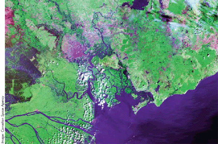
The main areas of data collected are hydro-meteorological, spatial,
socio-economic and environmental; plus data on fisheries. Hydrological
information comes from a network of hydro-meteorological stations
along the Mekong. Some of these transmit real-time information
on water levels and precipitation. Spatial data includes GIS
products and outputs from model scenarios.

The programme covers four main functions:
- Data collection;
- Data management;
- Data services;
- Knowledge management.
These functions are grouped into five thematic programme components: (1) Programme management; (2) Hydrometeorological data; (3) GIS and databases; (4) Modelling; and (5) Communications and knowledge management.
Component 1: Programme Management
The IKM Programme Document was improved and finalised in June
2007 following in-house and regional consultation meetings.
A Programme Implementation Plan was also developed while two
staff members, an Operational Hydrologist and an Administrative
Assistant were recruited. The IKMP modelling team is supported
by Finland.
Component 2: Hydro-Meteorological Data
The ongoing collection of critical time series data helps further
understanding of the physical condition of the mainstream and
major tributaries in the Mekong River Basin. Its greatest challenge
is the technical coordination of a wide range of data types
and a variety of institutions across the basin. A CD-ROM Hydrological
Yearbook for 2003-2004 was produced in 2007. Hydro-meteorological
data has now been collected from the Member States for up to
2005 and this is now being processed. IKM guidelines were drafted
and discussed at a regional meeting. After revisions following
the comments of the NMCs this work was incoporated into IKMP
procedures for updating and integrating AHNIP with the MRC Hydro-meteorological
network.
Component 3: GIS and Databases
A data and metadata repository constitutes the technical backbone
of the IKMP, providing the core services upon which all other
components depend. Tools are used to collect, manage and share
and exchange data and information in IKMP, other MRC programmes
and national agencies. The collection and supply of improved
hydro-meteorological information and maps to all programmes
continued in 2007. Remote sensed data and time-series data was
included as a tool for the project to strengthen flood management
capacity along the Kok River in Chiang Rai province of Thailand.
Training was provided to MRCS and national government staff
on image processing (ERDAS software), database management, and
remote sensing.

Component 4: Modelling
The Decision Support Framework (DSF) has been extensively used
in MRC programmes/activities and for other services, such as
for simulation of dry season flow releases from the Nam Theun
2 hydropower project in the Lao PDR. In the same country, the
modelling team provided technical scenario simulations for river
planning for the Nam Ngum. Draft technical guidelines were completed
for implementation of the Procedures for Maintenance of Flows
on the Mainstream, while a concept note was developed on the
Mekong tributaries flow contribution. Other activities relating
to the DSF enhancement and building modelling capacity included
creation of a DSF reporting tool wizard, and updating of the
Knowledge Base with four national consultants.
Component 5: Communications and Knowledge
Management
Sharing of data, information and knowledge within MRC programmes
and among external stakeholders is a vital part of the programmes
operations. Easy access and visualisation of data is made available
via standard internet-based services and there is also a focus
on eliciting soft knowledge - the tacit knowledge that exists
throughout the wide network of people who work within or interact
with the MRC. The MRC-IS web portal was built and tested and
will offer much improved external access to MRC documents and
data in the future. A library automation system was introduced
to the Documentation Centre and all bibliographical data records
converted to the new format. Also in 2007, the MekongInfo website
was transferred from the GTZ project to IKMP under this component.
Promotion of the riparian countries ownership of all MRC activities,
and development of their capability to effectively utilise these
assets, form a core part of ongoing actions. Consequently, a
good proportion of financial and human resources is reserved
to conduct national training programmes in GIS, database analysis
and modelling, with an emphasis on hands-on training, problem
solving and the development of independent capability.
Partnership with Other Regional Initiatives
Regional institutions and projects utilising IKMP data and modelling
results include:
- The World Bank (Delta Master Plan, MRC M-IWRM);
- Global Challenge Food and Water Program (MPOWER water governance);
- IUCN (Water and Nature Initiative Project);
- ADB (Tonle Sap Built Structures Project, RETA - The Sesan, Sre Pok and Sekong River Basins Development Study in Cambodia, the Lao PDR and Viet Nam);
- WWF (Environmental Considerations for Hydropower Development, Mekong Wetlands Project).
Choose a newsletter: