Living with floods – the Flood Management and Mitigation Programme (FMMP)
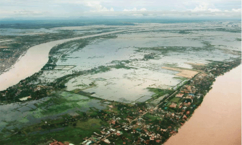
Floods along the Mekong have the potential to directly endanger life; do millions of dollars worth of damage to property; destroy livelihoods and crops; and put people at increased risk of poverty, malnutrition and disease. At the same time, they are an important and essential natural process, bringing water, nutrients and other benefits to floodplains, wetlands and ecosystems.
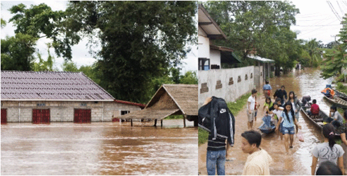
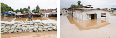
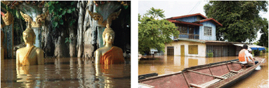
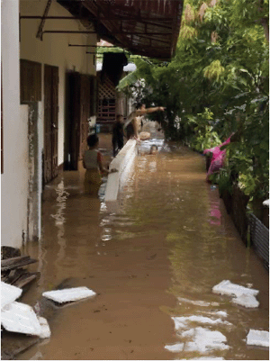
The disruption posed by floods was demonstrated very clearly in Vientiane, Lao PDR in August 2008. The water level reached on 15 August in Vientiane was the highest since record-keeping began in 1913. At 13.7 m above the gauge datum, the Mekong River was one metre higher than the maximum levels recorded in 1966, 1971 and 2002. The capital experienced its worst flooding for more than a generation. Tens of thousands of people were affected - many still receiving food aid by 2009.
The MRC's flood forecasting service became the focus of attention throughout the August 2008 crisis. The flood was a test of the organisation's ability to monitor river and weather conditions and forecast the likelihood of further flooding. The information provided by the MRC was important for Member Countries and the wider public in assessing the likely scale and duration of the flood and emergency response plans, as well as delivering assistance to affected areas. A number of important lessons were learnt as a result of the 2008 flood in terms of data collection, forecasting models, coordination with national agencies and communication. These lessons were consolidated into an action plan, now under implementation.
The Flood Management and Mitigation Programme (FMMP) helps to prevent, minimise or mitigate people's suffering and economic losses due to floods, while preserving the environmental benefits of floods. The MRC Regional Flood Management and Mitigation Centre (RFMMC) in Phnom Penh, which was officially opened in April 2008, provides technical and coordination services to the four Member Countries including forecasts, flood data, and training packages.
The FMMP activities are conducted under five components:
- Regional Flood Management and Mitigation (RFMM) Centre;
- Structural Measures and Flood Proofing;
- Enhancing Cooperation in Addressing Trans-boundary Flood Issues;
- Flood Emergency Management; and
- Land Management.
Establishment of the RFMMC - National Activities
Contribute to Regional Forecasting
In Cambodia, the Department of Meteorology and the Department
of Hydrology and River Works completed several phases of a project
designed to improve the monitoring of rainfall. Twenty-four
water level and rainfall stations were upgraded and established
with improved communication capacity by the implementation of
a system that uses mobile texting.
In Lao PDR, equipment has been purchased for the upgrading of stations, communication training for observers was completed and specialist software has been installed and tested allowing the Department of Meteorology and Hydrology (DMH) to upgrade 16 crucial rainfall stations in the northern part of the country.
In Viet Nam, a link between the National Centre for Hydrometeorological Forecasting's database system and the RFMMP was upgraded enabling automatic data exchange between the two bodies. Procurement of computers and instruments to upgrade district offices is presently underway. In Thailand, the RFMMC is planning to conduct a sensitivity analysis, which will be based on historic water level and rainfall data in order to identify, prioritise and assess the minimum future data requirements.
Agreement to share hydrological information
with the People's Republic of China
The agreement between the MRC and the People's Republic of China
to share information regarding hydrological variations upstream
was extended in 2008. The information from China improves the
accuracy of flood forecasts further downstream and eventually
leads to longer forecasting lead times.
Flood forecasting
The development of the new Mekong Flood Forecasting System is
at an advanced stage. The system uses a set of computer models
and past flood data to predict flooding more accurately than
was previously possible.
To address the threat of flash floods in the MRC Member Countries plans for the implementation of a Mekong Flash Flood Guidance System are well underway. A management mission to the USA took place in November 2008, and development work on the actual system is ongoing at the Hydrologic Research Centre in San Diego. Training andimplementation in Phnom Penh will take place during the 2009 flood season, though the system will not be operational until the 2010 flood season.
Communication and coordination
The web-based forecasting service of the MRC has been improved
and is now more user-friendly with summary information on flooding
displayed on the MRC home page. By the start of the 2009 flood
season, it will display the operational water level and rainfall
data of each Member Country, showing changes on a simplified
graph of the water levels at each forecast station.
One of the lessons learned from the 2008 flooding was the need for better protocols for contacting focal points in key country line agencies. These have been developed and will be in place for 2009.
Other related activities
- The 2007 Annual Mekong Flood Report with the theme “The flood hydrology of the major tributaries in the Lower Mekong”; and
- A widely disseminated interim report on the 2008 flood situation
The Environmental Considerations of Sustainable Hydropower Development project was formulated jointly with the Asian Development Bank and the Worldwide Fund for Nature. The project will develop a sustainability assessment methodology for hydropower projects based on international standards and suited to the Mekong Region.
Structural measures and flood proofing
In 2008 the project completed a flood damage/ risk assessment
and developed Integrated Flood Risk Management (IFRM) strategic
guidelines. IFRM planning and impact evaluation, as well as
the development and design of structural measures and flood
proofing were also carried out. Demonstration projects and capacity
building programmes had been completed by the end of 2008.
Enhancing cooperation in addressing transboundary flood issues
The FMMP has focused on improving the skill level of national agencies and MRCS staff in conflict management and addressing differences and disputes related to transboundary flood and related resources issues. Preparatory work was carried out for a wide range of training in this area which began in 2008 and is due to end by September 2009.
Flood emergency management strengthening
(FEMS)
A new 15 month project entitled "Strengthen Development
and Implementation of Flood Preparedness Programs at Province,
District and Commune levels in the Lower Mekong Basin, Phase
IV" started in August 2008. It will be completed in October
2009.
Land Management
Activities implemented by GTZ in 2008 included the continuation
of training courses in land-use planning for the line agency
staff in four riparian countries. Seven pilot districts, two
each in Cambodia, Lao PDR and Viet Nam, and one in Thailand,
were identified in 2008 for project work to begin.
Choose a newsletter: