4. Impacts of the 2005 Flood (cont')
4.2 Impact of the 2005 flood
Severe flash floods occurred on several Mekong tributaries in Lao PDR and in the province of Chiang Rai in Thailand, damaging roads and bridges, irrigation schemes and other village infrastructure such as schools, water supplies and health centres.
Exceptionally abnormal flood conditions affected the central and southern provinces of Lao PDR and the corresponding provinces of Thailand located along the Mekong. This was due to severe flooding in the tributaries coinciding with very high water levels in the Mekong which generated an extended and lengthy backwater effect. This was considered the most damaging flood for more than 30 years. The most affected districts were located in Khammouan Province in Lao PDR and in Nakhon Phanom Province in Thailand. Savannakhet (Lao PDR) and Mukdahan (Thailand) were severely affected as well. These flood conditions also occurred in the southern provinces of Lao PDR, the corresponding provinces of Thailand, as well as in the northern provinces of Cambodia, namely Stung Treng and Kratie, but with less damaging effects.
The province of Kompong Cham in Cambodia, located at the top of the Cambodian flood plain, was well flooded due to the high level of the Mekong but the flood was nothing exceptional. Below its confluence with the Tonle Sap River, the water level of the Mekong decreased in intensity which meant that the flooding situation in Kandal and Prey Veng provinces in Cambodia were recorded as "normal".
In Viet Nam, the flood conditions and impacts were also reported as "normal". Even if substantial damage was recorded in the Mekong Delta, 2005 was the least damaging year since 2000. The production of paddy reached 17.2 million tonnes and, the government considered 2005 a successful year for crop production.
Figure 16 shows an estimate of the damage caused by the 2005 flood in the LMB. Unfortunately, some data could not be reconciled or they are missing. For this reason, a full consolidated listing of the impacts of the flood in the LMB for the year 2005 can not be presented.
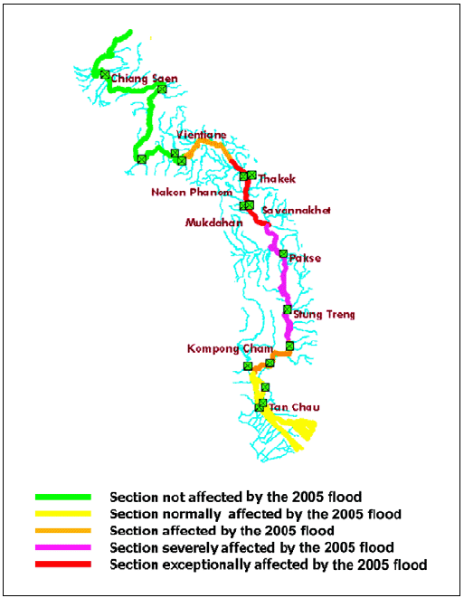
Figure 15: Map of the sections of the
lower reach of the Mekong River affected by the 2005 flood.
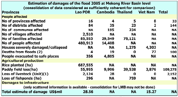
Source and comments related to data: see country reports. (1)
includes buffaloes, cows, pigs, goats (2) data regarding flash
floods not available
Figure 16: Damage caused by the 2005 flood in the LMB
Figure 17 shows the loss of paddy fields by provinces. For
future reports, it would be valuable to obtain these
data by districts rather than provinces and in percentage of
loss rather than in absolute values. The map confirms
clearly that the areas most affected by the 2005 flood were
the provinces of Khammouan in Lao PDR and Nakhon
Phanom in Thailand.
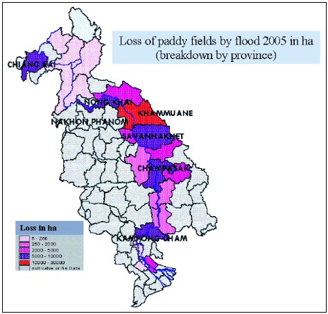
Figure 17: Map of provinces affected by
loss of paddy fields in the LMB
Choose a newsletter: