8. Responses to flood events - Country Reports
8.1 Responses to flood events in Cambodia
8.1.1 Non-structural
In Cambodia, flood management, mitigation and reporting on flood impacts are the responsibility of the National Committee for Disaster Management (NCDM). This Committee acts at four levels. The national level works under the coordination of a ministerial level working group, which is chaired by the Ministry of Water Resources, and includes the Ministries in charge of agriculture, health, environment, public works, interior, defence and municipalities. A similar multi-disciplinary group has also been set up at provincial level. At district level, some of the technical departments are represented in addition to commune chiefs. The Communes Disaster Management Committees include the village chief and responsible members of villages as well as the Red Cross "EWS" Volunteers in the villages where an Early Warning System (EWS) has been set up.
8.1.2 Flood Early Warning and Disaster Preparedness
The United States Office of Foreign Disaster Assistance and the Mekong River Commission signed a Cooperative Agreement on 16th December 2002 entitled, "Provision of Flood Early Warning to Flood-Vulnerable Communities in the Lower Mekong Basin, Phase 1: Cambodia and Lao PDR". The project is implemented under the overall umbrella of the Flood Management and Mitigation Programme (FMMP). It started in 2003 in Cambodia in cooperation with the American Red Cross, Action Contre la Faim and Cambodian Red Cross. A similar project is expected to start in 2006 in Lao PDR. The project is also intended to assist flood-at-risk communities to make better use of MRC flood forecasts and warnings, which are issued during the annual flood season.
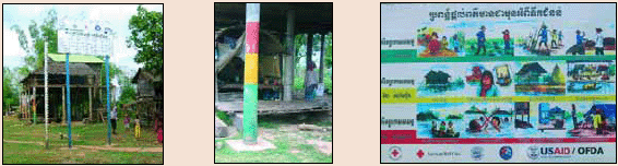
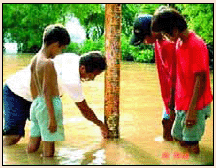
In Cambodia, the project covers a total number of 40 villages. It includes the installation of flood markers and flood alarm stage boards. Support to the villagers for improving their knowledge on flood early warning and emergency response is provided as well. The empowerment of the communities' involvement in the project planning, implementation, and monitoring and reporting is developed at provincial level and Red Cross volunteers assume an important role in each of the villages.
It is important to note that in those provinces, there were complaints about the MRCS standard level for defining alarm stages and flood stages. In Kratie, the warning level is 22 m although when the level of Mekong exceeds 20m some villages are already flooded. This means that a level of 1 m under the flood warning can cause damage.
The Department of Hydrology and Water Resources (DHRW) plays an essential role in installing and monitoring the village flood markers. They also provide daily flood forecasting data to the villages, comparisons between observed and forecasted daily water levels in every village as well as correlation hydrographs between the main stations and the village flood markers.
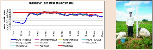
Flood markers have been installed within the framework of the Flood Early Warning project in approximately 40 villages in Cambodia. The flood marks have been level surveyed. The measurement of the geographical locations, position and elevation of 15 villages was based on the benchmarks of the main hydrological stations. This work is not only useful for gathering data and information, but also for modelling and other purposes in the future, especially for water resources management and flood forecast routing. This also allows us to obtain data not only on the Mekong, but also at village levels and measurements show that levels recorded at the Mekong station in Stung Treng may be lower than in some villages. This justifies the need to extend flood prediction to the level of communities at risk.
In Kompong Cham Province, The Disaster Preparedness Programme of the European Community Humanitarian Office (DiPECHO) supports Action Contre la Faim, Oxfam and the Provincial Committee Disaster Management (PCDM) in broadcasting flood information through three radio spots in Khmer language. Prior to the floods the spot focuses on the causes of floods and preparedness before the flood season, highlighting simple measures villagers can take. During the floods, the spot focuses on the dissemination of flood information/early warning systems and the responses when the warning level is reached. After the floods, the spot explains important and simple measures to be taken when floods are receding in order to avoid health problems and accidents.
The project "Provision of Flood Early Warning to Flood-Vulnerable Communities in the Lower Mekong Basin, Phase I" which is under the umbrella of the FMMP, aims at reducing the vulnerability of communities in Cambodia to higher-than-normal annual floods and flash flooding, by providing timely flood warnings. Communities are equipped with tools and trained at the same time. The establishment of a continuous dialogue and exchange of information between MRCS and the target communities ensures accurate and appropriate flood information and assessment of community flood-warning needs.
8.1.3 Infrastructure
In Cambodia there is limited infrastructure for controlling floods, except for some main road sections built on embankments such as National Road No 6. There are no regulators or "colmatage" gates in the Northern section of the Mekong that could manage/limit the effect of backwater entering into the tributaries. Four control gates (9m wide and 13.5m long) have been built on National Road No 1 from Phnom Penh to Neak Loeung (funded by JICA), and these control the backwater from the Mekong to rice cultivated areas.
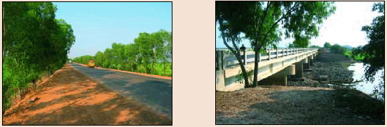
Road No 6 has been built between Tonle Sap River and the Mekong floodplains on an embankment with bridges which allow the flow from the Lower Mekong Basin to the Tonle Sap River/great Lake in the event of high water levels in the Mekong.
Choose a newsletter: