7. Viet Nam 2007 country report
7.1 General Situation
Seven typhoons and three tropical depressions, originating in the South China Sea, affected the Vietnamese regions of the LMB during 2007, of which those designated Numbers 2 ('Pabuk' in Cambodia) and 5 during August and November caused major flash floods in the Upper Se San and Sre Pok Basins. Flooding in the Delta was minimal, except during spring tides when areas of Can Tho City are inundated. Peak water levels occurred late on the 23rd October at Tan Chau (see Figure 32), though higher water levels late in the season has its advantages for the agricultural sector and the movement of irrigation water. Flood erosion, however, remains a significant issue in the Delta, even during years when discharges are modest, as they were throughout 2007.
7.2 Typhoon No.2
In August flash floods occurred within tributaries of the upper Se San and Sre Pok Rivers caused by exceptional storm rainfalls between the 2nd and 5th August associated with Typhoon No.2.
Table 17. Cumulative rainfall in
the Upper Sre Pok and Se San Basins over the three days
between August 2nd and 5th. ![]()
| Station | River basin | Rainfall (mm) |
| Buon Ma Thuot | Sre Pok | 323 |
| Buon Ho | Sre Pok | 575 |
| Giang Son | Sre Pok | 307 |
| Duc Xuyen | Sre Pok | 200 |
| Cu Mgar | Sre Pok | 571 |
| Ban Don | Sre Pok | 220 |
| Krong Buk | Sre Pok | 619 |
| Krong Bong | Sre Pok | 431 |
| Ea Hleo | Sre Pok | 446 |
| Dak Lei | Se San | 264 |
| Kon Tum | Se San | 171 |
Over wide areas total rainfall over the three days was between 300 and 400 mm resulting in local flash floods and water levels on the Sre Pok exceeding alarm level III (for definition see Appendix 8 of the Annual Mekong Flood Report 2006). The most serious loss and damage occurred in Dak Lak Province.
7.3 Typhoon No.5
Heavy rain of between 100 and 300mm over four consecutive days from the 7th 11th November occurred over Kon Tum Province as a result of Typhoon No 5. Devastating deluges followed in the Upper Se San tributaries, particularly the Dak Bla and Krong Poko. Several floodplain villages were rapidly inundated to a flood depth one to one and a half metres with the Kon Plong District the worst affected.
7.4 Damage and impacts
Serious damage to infrastructure, agricultural production, and human settlements resulted from Typhoon No. 2 during early August. In Dak Lak province 23 people died and losses to the provincial economy estimated at US$5 million. Over 10,000 properties were inundated, more than 41,000 ha of agricultural lands flooded and 70 water control projects destroyed or damaged.
The flash floods, landslides and debris flows that took place in November as a result of Typhoon No. 5 caused extensive damage in the upper Se San. In Kon Plong one person died, four bridges were either damaged or completely destroyed and several villages flooded and cut off. The remoteness of many of the villages made rescue and repair operationally challenging.
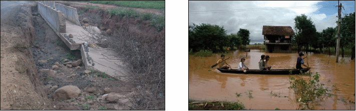
Figure 42. Destroyed irrigation
canal in Dak Lak as a result of Typhoon No. 2 and a flooded
village in the Se San Basin following
Typhoon No. 5.![]()
7.5 Lessons learnt
The governments approval of the National Strategy for Natural Disaster Prevention, Response and Mitigation to 2020 during November 2007 will provide the political framework for the promotion of flood management and mitigation policy at the national and regional levels. In addition to the ongoing needs for training and investment in flood protection and mitigation measures, the specific lessons from the events in 2007 include:
- The need to recognise the flash flood problems in the more remote regions of the upper Se San and Sre Pok and to balance the investments made in flood protection in these areas with those made elsewhere. It is inevitable that most investment will be made in the more economically important regions such as the Delta, but upland flash floods are likely to become an increasing hazard that requires the development of management and mitigation strategies and investment in measures that reduce the number of people exposed to the risk.
- There is also a need to better understand the flash flood phenomenon so that forecasts and warnings can issued accurately and in time.
- Telecommunications with remoter villages at risk from flash floods could be improved.
Choose a newsletter: