2. Flood benefits
2.2 Flood benefits - agriculture
A key feature of the annual Mekong flood is that in terms of its timing it is highly predictable, particularly in terms of its onset in early July. This feature it shares with the Nile flood, for example, which enabled Egyptian society to develop a planned and highly seasonal form of agriculture with a relatively high level of crop security leading to food surplus in most years. This said, however, the periodic failure of the annual flood over consecutive years led to famines of which several are chronicled in the annals of Ancient Egypt. There is little doubt that droughts would also have occurred and caused food shortages at the time of the ancient Mekong civilizations, but such events are unrecorded. In Cambodia these societies were largely rural, supporting ceremonial centres with rice and labour. It has been argued that the later states and kingdoms that evolved there and in Thailand and Lao PDR took the form of social systems based on cooperative villages which had a common form of agricultural production based on monsoon rainfall and to some degree on various forms of flood irrigation. They are referred to as 'agro-cultural complexes'.
This type of rural balance between a subsistence form of agriculture and the provision of food to political and religious centres largely prevailed in the Mekong region until the colonial era and the beginning of large scale commercial resource development. French statistics (Van Liere, 1980) suggest rapid agricultural growth and environmental change during this period. From 1880 to 1930, the total volume of earth dredged in the Mekong Delta totalled 165 million cubic metres which compares with 210 million for the Panama Canal and 260 million for the Suez. These new canals drained large areas and complemented the demands from an increasing population of ethnic Vietnamese farmers migrating from the north. Cultivated land area rose from 200,000 hectares in 1879 to 2.4 million in 1929. This represented an increase from roughly 5% to 60% of the total surface area in the Vietnamese portion of the Mekong Delta.
The aim was, through public works, to drain the delta's swamps, marshes and forests to exploit the fertile alluvial soils that were the legacy of thousands of years of the flood regime of the Mekong and transform the landscape into one dominated by highly productive rice paddies. This impressive rate of growth meant that by the 1930s the delta has already become one of the worlds major rice exporting regions. It was still, however, largely uncontrolled in hydraulic terms, particularly with regard to flooding and salinity intrusion, which were seen as major obstacles to the development of intensive farming and multi-cropping systems (Kakonen, 2008).
It was not until the 1980s that the necessary intake and outflow structures were constructed on a large scale to regulate flows to and from the fields and not until the 1990s that hydraulic infrastructure was completed that reduced dependence on natural hydrological conditions and which enabled the control of floods, salinity and the cropping limitations imposed in some areas by acid sulphate soils. Consequently, by 1997 Viet Nam had become the world's second largest rice exporter, shipping some 3.5 million tonnes to the global market. A statistical summary of the contribution that the agricultural outputs of the delta currently make to the Vietnamese economy (General Statistics Office, 2004) is set out below. It produces:
- About half of the national food output;
- 51% of the total rice paddy production;
- 55% of the national inland fisheries and fruit output;
- 60% of the countrys exported aquaculture products;
- 61% of the total national export value.
Of course it would be quite wrong to suggest that these contributions to the national economy are entirely the result of the Mekong flood regime — they are the outcome of converting the natural floodplain into a highly controlled and intensive agricultural landscape. But the nature of the landscape that provided the opportunity to do so is the result of the hydrology of the river and the benefits that have accrued from the annual flood over thousands of years.
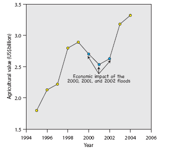
Figure 2.3: The value
of agricultural production in the Mekong
Delta (1995 2004) in Viet Nam. The chart shows significant
annual growth over period, but also that this growth can be
disrupted during years of extreme flood conditions.
Figure 2.3 shows the significant rates of annual growth in agricultural production in the Mekong Delta to 2004, when its total value reached US$3.3 billion. The figures also illustrate, however, that this systematic increase in monetary value can be interrupted in years when flood discharges and water levels exceed critical thresholds, as they did between 2000 and 2002.
These figures refer only to that part of the delta in Viet Nam, though it is generally regarded as beginning at Phnom Penh in Cambodia, where the Mekong divides into its two main distributaries, the Bassac and the Mekong (Tien). It comprises a vast triangular plain of approximately 5.5 million ha of which 1.6 million are in Cambodia and mostly lies below 5 masl. The 9 to 13 millions tonnes of sediment deposited annually, most of it during the flood season, has resulted in some of the most productive agricultural land in Southeast Asia.
Unsurprisingly therefore the flood inundated areas of the delta are amongst the most fertile regions for agricultural production in Cambodia, with extensive double cropping. Rice occupies 90% of the total cultivated land of which 32% lies in flood prone areas. Because of the fact that only 7% of the land is irrigated it is only in these naturally flooded areas that a second crop is possible on any large scale using receding water around lakes and rivers. Interestingly this second dry season flood recession crop usually gives higher yields than the wet season crop due to more controllable water management, the lower risk of crop losses due to excessive water depth and the benefits obtained from the deposition of fertile sediment during the flood itself.
Cambodia harvested more than 6,264,000 million tonnes of rice in 2006. Taking current 2008 price of US$ 500/million tonnes and the fact that of the 2006 figure 32% was harvested from the floodplain areas then the flood benefit value is US$1 billion.
In Lao PDR 80% of the cropped area is planted to rice, of which 75% is rain fed lowland paddy in areas of low flood risk. The balance is made up of rain-fed upland rice which has quite low yields. Only about 10% of the planted area is irrigated contributing about 14% to national production. Although overall, rice production accounts for 20 to 25% of GDP there isn’t the strong linkage between the annual flood in the Mekong Basin and agricultural production that there is in Cambodia and the Delta in Viet Nam. FAO figures indicate that in 2005 rice production in Lao PDR totalled 2,600,000 tonnes, of which only 5% is marketed commercially. The planted area was 736,000 ha giving a yield of 3.5 tonnes/ha.
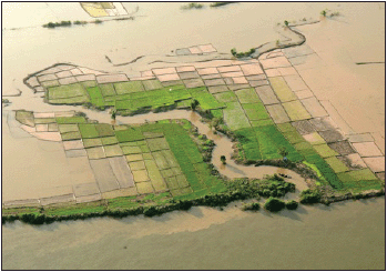
Figure 2.4: Flood recession
rice cultivation on the Cambodian
floodplain.
There are local areas of rice paddy close to the Mekong mainstream and in the lower reaches of the large tributaries in Lao PDR that are inundated during most years and which are exploited for agricultural production, including the growing of vegetables and maize as well as rice. Most of the islands in the mainstream are used in this way. Although in total the area is probably substantial and the economic benefit significant, this sector of the agricultural economy is not identified separately in the compilation of agricultural statistics since it is generally informal, with outputs traded locally, if at all. The wider commercial benefits of agriculture in Lao PDR may therefore be considered to be independent of the Mekong flood.
In the Thai Mekong region traditional forms of agriculture that exploit seasonal floodplain and wetland inundation are now increasingly scarce, as more intensive forms oriented towards external markets have taken over from subsistence and small scale farming. According to Fukui and Hoshikawa (2003) the shift towards large-scale rain-fed production in Isaan only began during the 1950s, prior to which a flood dispersion system known as Tham Nop, was generally used, an example of which is illustrated in Figure 2.5. Earthen bunds were constructed across small tributaries to divert early season floodwater onto pre-prepared paddy fields typically covering a 300 – 500 ha area on the flood plain and low lying riparian lands. According to the first village economic survey in Thailand in 1930 – 31 (Zimmerman,1931), the average yield of rice in the northeast of the country, based on this limited system, was most probably higher than in the central region, which had become Thailand’s rice-bowl for export production (Fukui and Hoshikawa, 2003). The report goes on to describe the very low density of population in the northeast and its concentration along rivers where the local economy centred around the exploitation of aquatic resources.
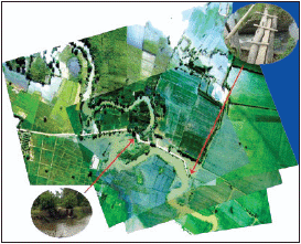
Figure 2.5: An example
of the 'Tham Nop' flood
diversion system from North East Thailand.
(Fukui and Hoshikawa, 2003). A bund is constructed
across the river and early season flood water diverted
onto riparian rice paddy. Water levels are controlled by
simple timber gates. Typically these tradition water
control schemes provided flood irrigation to 200 to 500 ha.
Post 1950 rural development policies in the Thai Mekong region, particularly in the Mun – Chi basin, focused on agriculture and the provision of reservoir storage for direct gravity fed and pumped irrigation from regulated rivers. The population grew five fold in 50 years from 5 to 25 million, of which 70% remains rural and involved to some degree in agriculture. Rain fed rice production dominates the rural landscape, covering 75% of the agricultural land. In 2006 total rice production in the Thai provinces that lie within the Mekong Basin totalled 10.5 million metric tonnes (FAO Figures), with a current (February 2009) value of US$5.25 billion.
With less than 1% of the regional land classified as flood plain the role of the annual flood in generating this agricultural benefit in the Thai Mekong region is minimal. Small scale rice growing systems using flood recession trap ponds do still exist along with instances of traditional mixed crop farming using flood recession terraces on riverbanks, for example in the Nam Songkhram river basin. Such activities are, however, usually uncommercial and generate benefits only at the household or village level.
Summarizing the annual agricultural flood benefit gives a total regional figure of US$4.5 billion, which is generated in Cambodia and Viet Nam alone. In relative terms the outputs of floodplain agriculture in Lao PDR and Thailand are considered to be insignificant compared to rain fed and irrigated production (Table 2.2). The overall figure is probably conservative since, although it is based on a rice price of US$/500 a tonne, which represents a significant recent increase, the value of other crops has not been included. To do so would be complex since production and market value figures are not generally available in a form that permits a breakdown in a way suitable for the present purposes. It is also true to say that fruit, vegetables and other crops that are grown on a commercial scale are produced in areas not directly at risk from flood inundation except under the most extreme hydrological conditions. Rice on the other hand is the archetypical flood plain crop and production clearly benefits from the annual flood in most years.
| Country | Estimated annual agricultural value accruing from the annual Mekong flood (US$ billion) | Comments |
| Cambodia | 1.0 | 2006 figures. Based on rice occupying 90% of agricultural area of which 32% lies in flood prone areas. |
| Lao PDR | Not significant | Only local flood recession agriculture – most production combines rain fed summer and irrigated winter crops. |
| Thailand | Not significant | |
| Viet Nam | 3.5 | 2004 figures for production in the delta, which is itself a long term product of the annual flood. |
| Total | 4.5 |
Choose a newsletter: