3. Flood Costs
3.2 Flood damage assessment in the Lower Mekong region
In the Mekong region flood damage data are collected by the national disaster management organisations that have been established in each of the four countries. The data are obtained on the basis of surveys, interviews and questionnaires and are therefore not available for some time after the event, though early rapid assessments are undertaken to inform governments of the expected scale of economic loss and damage. For most structural damage categories, the financial loss increases as a function the depth of inundation though the duration of flooding also plays an important role, for example damage to building foundations in expansive clay soils rises exponentially with increasing duration of saturation. Earth flood protection levees fail not only as a result of overtopping but also because of extreme durations of high water level causing saturation and collapse.
Crop damage is related to both the depth and duration of flooding as are livestock losses. Costs in the communications sector are also related to both with erosion of embankments an additional factor which is linked to flow velocity. Throughout all damage sectors sediment deposition is a major factor.
At the broadest level flood losses are measured in financial terms though there are important intangible social consequences including distress, health issues and ultimately loss of life. The nature and severity of the flood conditions provide one set of variables that determine overall damage while the land use makes up the balance. The depth of inundation, its duration above critical thresholds, the velocity of overland flow and the amount of sediment deposited comprise the major hydrological and hydraulic factors. These, however, exert varying types of impact depending on land use factors. Flood depth is often used exclusively to define damage in the residential sector on the basis of damage - depth curves. The relationship between depth and damage in the industrial and commercial sectors is more complex and can only be meaningfully established on the basis of detailed surveys. In the agricultural sector the relationship between depth and damage is related to the time of the year, the stage of development of the crop, the type of crop and the length of time that critical water levels are exceeded.
Depth – damage relationships can be extended to encompass frequency aspects such that the overall value at risk can be expressed within an annual probability framework. However, drawing indirect and secondary damages into such a model is extremely difficult while the depth of inundation is simply just one aspect of the nature of the flood event that requires consideration in the evaluation of overall costs. Some authors, for example Smith (2004), argue that the other components of the flood hydrograph, such as duration, flow velocity and turbulence are so highly correlated with inundation depth that they can be ignored. This may be so for floods smaller river systems but as scale increases the argument becomes less tenable. The 2000 flood in the Lower Mekong, which caused the most damage in decades was characterised not by its peak discharge and maximum water levels, which were not extreme, but by huge volumes of flood runoff throughout the flood season which resulted in unprecedented durations of flooding which determined by far the greater proportion of the total losses.
Depth – damage curves have not been applied to the assessment of flood costs and losses in the Mekong region by the relevant national agencies who provide data based on surveys and a loss per unit area approach. Meanwhile, research and pilot studies have been limited. Das Gupta et al. (2004) estimated curves for flood damage assessment in the delta in Viet Nam based on modelling the annual flood hydrograph on the Mekong mainstream at Kratie for various recurrence intervals and then predicting the area inundated. Land use was classified into four groups, namely residential, commercial, agriculture and infrastructure. Losses were based on field surveys and included secondary costs such as those arising from the suspension and reduction of commercial and industrial production. Potential agricultural losses were determined using yield and average market crop value figures.
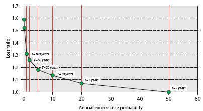
Figure 3.2 Growth in agricultural
losses in the Mekong delta in Viet Nam
as a function of flood frequency, according to Das Gupta et
al. (2004).
These results imply that the losses during a 100 year event
are only
15% higher than those during a 10 year event, which seems
too low.
Comparable results in Australia indicate a difference of the
order of 15 times.
Despite what appeared to be a sound experimental design the damage figures obtained by Gupta et al for flood conditions of various risks of occurrence are huge and bear no relationship at all to those provided by the Vietnamese disaster management agencies. For example, they indicate that a 1:10 year event would generate damages to a total of US$54 billion, which is indefensible. This figure compares to the official estimate of losses during the extreme flood conditions of 2000 of US$50 million. The research results contend that 97% of these huge potential losses lie in the commercial sector and it is here that the major errors appear to mainly lie. For example, the authors propose that the economic value of commercial output losses after the event amount to over 50% of annual production, which seems extreme.
Even the rate at which damage increases as an inverse function of flood frequency appears to be unrealistic. Figure 3.2 shows the growth in agricultural flood damage in relation to flood magnitude expressed in annual risk terms. The authors suggest that damage arising from a 100 year flood is just 15% higher than that for a 10 year event. Australian data on the other hand indicate that flood damage in the agricultural sector arising from a 1:100 year event is at least 15 times larger than that for a 10 year event (Agricultural and Resource Management Council of Australia and New Zealand).
Haskoning (2008) undertook pilot socioeconomic surveys in nine focal districts in Cambodia, Lao PDR and Viet Nam in order to establish depth damage data and provide a basis upon which the potential cost benefits of flood management and mitigation measures could be assessed. The Vietnamese provinces of Dong Thap and An Giang provide data for the perennially flooded areas of the delta bordering Cambodia for which the depth damage relationships are shown in Figure 3.3.
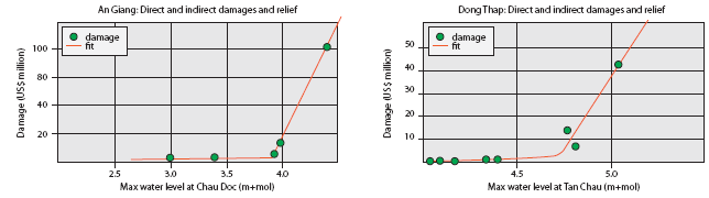
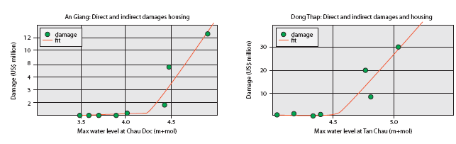
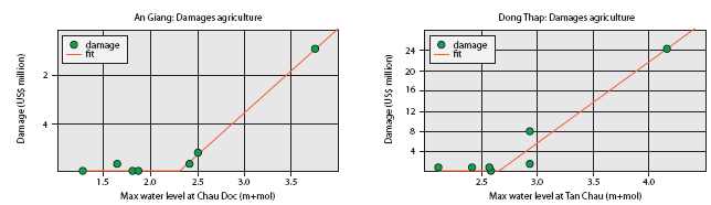
Figure 3.3 Sectoral flood
damage curves for the Mekong Delta. (Source: Haskoning, 2008.)
- In each sector there is a threshold water level at which damage begins to accumulate, which for infrastructure and residential properties is when levels observed at Tan Chau and Chau Doc exceed 4 to 4.5 masl.
- Damage to agriculture begins at water levels that are 2 to 2.5 m lower indicating that in these areas where the annual flood risk is high, property and service facilities are generally elevated either on columns or more widely on embankments.
- The major component by far of overall damage is that caused within the infrastructure sector.
- These damage curves were used to develop annual time series of flood costs back to 1910 using historical water levels observed in the delta, which in turn permitted an estimate of the frequency distribution of annual flood damage to be derived (Figure 3.4) for the two delta provinces.
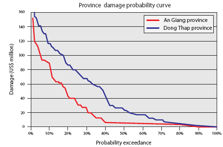
Figure 3.4 Frequency distribution
of annual flood damage in the Mekong Delta.
(Source: Haskoning, 2008)
Similar results are available for the pilot study areas in Cambodia and Lao PDR. Such is the spatial complexity of flood conditions in the Mekong region and the geographical variation in land use that these results cannot realistically be generalised. They do, however, provide far reaching insights into the nature and structure of flood damage within key areas such as the delta in Viet Nam, the Cambodian flood plain and those extensive areas in Lao PDR that are vulnerable to backwater flood effects between the large tributaries and the Mekong mainstream. Not least they enable the cost benefits of flood mitigation measures within these vulnerable areas to be established with a considerable degree of confidence.
Choose a newsletter: