5. The 2008 flood season
5.4 Water Levels
The water level at reached Vientiane on the 15th of August was the highest recorded since records began in 1913. At 171.7 masl it was 1 m more than the maximum levels achieved in 1966, 1971 and 2002 (Table 5.3). Conversely, upstream at Chiang Saen and Luang Prabang the 2008 maximum water levels were lower than those experienced in 1966 and by as much as 3 m at Chiang Saen.
The much higher 1966 water levels at Chiang Saen point to the fact that in September 1966 tropical storm Phyllis tracked further north than did Kammuri in 2008. So while much of the floodwater in 1966 originated in Yunnan, in 2008, by far the major contribution appears to have come from the large left-bank tributaries in northern Lao PDR such as the Nam Tha, Nam Ou and Nam Khan. It is also worth noting that the rapid water level rise at Luang Prabang occurred one day before water levels rose at Man An tributary station in China. This also strongly suggests that the flood event was primarily caused by heavy rainfall in the basins of the Mekong tributaries in northern Lao PDR.
| Year | Maximum
water level achieved (masl) |
||
| Chiang Saen | Luang Prabang | Vientiane | |
| 1924 | No data |
No data |
170.7 |
| 1929 |
- |
- |
170.4 |
| 1942 |
- |
- |
170.2 |
| 1966 |
370.9 |
289.6 |
170.7 |
| 1970 | 366.9 |
285.0 |
170.2 |
| 1971 | 368.1 |
287.4 |
170.5 |
| 2002 | 367.5 |
285.1 |
170.6 |
| 2008 | 367.7 |
287.6 |
171.7 |
As further confirmation of this, Figure 5.7 indicates that water levels during August remained below the flood warning and inundation levels at Chiang Saen but at Luang Prabang, Vientiane and Nong Khai the flood inundation levels were exceeded for up to 10 days and by considerable margins. Downstream of Nong Khai and towards Nakhon Phanom there were no significant additional contributions to these floodwaters that largely originated in Northern Lao PDR such that at Nakhon Phanom itself the maximum water levels reached in 2008 fell well short of the alarm level.
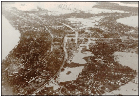
Figure 5.6: The extent
of flooding across Vientiane on the 1st September 1966, indicating
the potential disaster that was averted by the prompt actions
taken during mid August, 2008.
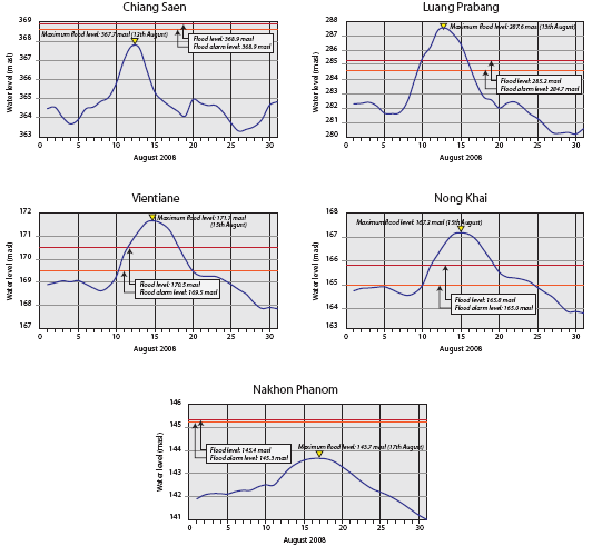
Figure 5.7: August
2008 water levels on the Mekong mainstream between Chiang
Saen and Nakhon Phanom compared to flood alarm levels.
At Pakse the flood alarm level was reached for a few days following the 14th of August, whereas at Kratie maximum flood levels peaked 1 m below the alarm level. In the Delta at Tan Chau and Chau Doc the alarm stage was exceeded from early August to late November but such conditions occur even in an average flood year, given the low lying nature of the landscape.1
______________
1 Flood warning levels in the Delta were set before much of the flood protection infrastructure was completed. They are currently recognised as too low and are under review.
Choose a newsletter: