Navigation Programme
International navigation is one of the most important mandates of large river commissions.
Navigation News
Cambodia and Viet Nam formally open-up cross-border river trade on the Mekong
Cambodia and Viet Nam have signed a treaty that will allow freedom of navigation on Mekong waterways between the two countries and increase access to the river system for foreign vessels.
The Treaty on Waterway Transportation, signed by both countries in Phnom Penh today, legally binds Cambodia and Viet Nam to reducing the official restrictions that have existed for cross-border navigation. Both governments say that the move will ... more »
Read the agreement
» English (pdf 1.7MB)
» Khmer (pdf 1.6MB)
» Vietnamese (pdf 1.8MB)
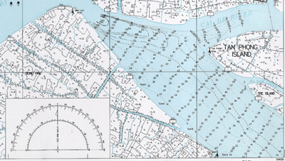
The Mekong Navigation Programme analyses river transport systems and related activities in the Lower Mekong Basin, covering a network of 4,500 km of waterways. Within the basin both maritime shipping and inland water transport (IWT) play significant roles in livelihoods and economic growth as direct access.
Both of these sectors remain under-utilised and somewhat inefficient in terms of management: waterways could be used far more for transport and offer great advantages in terms of economic and environmental costs. Since the inception of the programme considerable advances have been made in enabling the use of the Mekong and its tributaries as transport and freight routes.
The MRC Navigation Programme combats poverty and helps its
Member States to achieve the Millennium Development Goals by
creating the opportunities to:
- Transport the agricultural produce of remote farmers;
- Reduce transport costs;
- Access schools and hospitals in rural communities;
- Establish micro-financing and small-scale investment schemes;
- Improve navigation during the flood season;
- Give women more access to water transport;
- Increase direct and trickle-down job opportunities.
![]()
The main sectors, history, accomplishments and components of the programme are described in brief here. For more detailed information click on the links to each component booklet, to our other technical publications, or contact us at the MRC Secretariat.
Maritime Shipping
The programme researches and gives advice to national governments on maritime law and on the possibilities of increasing trade, transport and tourism via sea routes.
For example, it has been shown that increased use of the routes between inland Cambodia and maritime destinations such as Hong Kong could drastically reduce freight costs for regional producers and traders. The MRC is also advising tourism authorities and operators of the possibility of sailing 350-person luxury cruise ships from the ocean and up the Mekong as far as Phnom Penh.
Inland Water Transport (IWT)
In parts of the basin the Mekong, its tributary rivers and connected lakes form the only communication route or means of transport for people and cargo such as agricultural produce. 20-25 m tonnes of cargo are moved in the Delta area every year on around 350,000 family boats, while container traffic between Cambodia and Viet Nam is growing rapidly.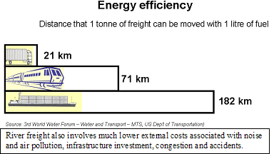
The role of the MRC in assisting with the development and improved use of these waterways is complex: in many places the river actually forms the border between countries. The Navigation Programme is helping the Member States to set up better co-operation on sharing of routes and with co-ordination on cross-boundary issues.
Programme History
Formulation of a Navigation Strategy and Programme began in September 2002. The basic premise was to further develop various previous projects designed to implement Article 9 of the 1995 MRC Agreement: Freedom of Navigation. Programme objectives can be summarised as:
- To promote freedom of navigation and to increase the international trade opportunities for the MRC member countries' mutual benefit;
- To assist in co-ordination and co-operation in developing effective and safe waterborne transport in a sustainable and protective manner for the waterway environment.
Major Achievements
- Ferry construction in Cambodia (US$20m)
- Feasibility Study for the Improvement of the Access Channel to the Bassac River
- Harmonisation of Aids to Navigation (with ESCAP)
- Development and construction of low cost bank protection
- Emergency bridging in Cambodia
- Updating of the My Thuan bridge feasibility study (height clearance)
The Navigation Programme works through five components. Click on each to download detailed description booklets:
- Socio-economic analysis and regional waterborne transport planning [for activities see box]
- Legal framework for cross-border navigation
- Traffic safety and environmental sustainability
- Information, promotion and coordination
- Institutional development
Activities: Socio-economic analysis and regional waterborne transport planning
- Traffic and trade scenarios;
- Master plan for regional waterborne transport and development of rural water transport (transport model + socio-economic outcome analysis);
- Recommendations for prioritised investments in the inland waterway infrastructure;
- Master plan for Mekong navigation in Cambodia;
- Improvement of navigation conditions on the Mekong in Viet Nam;
- Pilot project in the Lao PDR: impact of morphological changes and sedimentology;
- Pilot projects on tourism and navigation;
- Training.
Component 1: Socio-economic analysis and regional waterborne transport planning
Key issues:
- The region's rivers are still underused for domestic and cross-border trade, including tourism;
- Many remote riverine communities remain isolated and depend on traditional craft; their access to river transport needs guaranteeing and widening.
Through the work of this component the MRC has become a partner in several regional river development initiatives: Master Plan for Navigation in Cambodia (CNMC- Belgium) Chong Kneas Port Development (ADB) Mekong River Navigation Study (VNMC - Belgium) The Bassac Feasibility Study for Navigation (World Bank) The Quadripartite Agreement between China, Lao PDR, Myanmar, Thailand
| Component 1 Achievements | Next Actions in Component |
| Final report on technical feasibility of dredging a channel in Tonle Sap Lake. Initial results showed that dredging a small channel would require almost no maintenance dredging. However, stability of the channel is uncertain without experimental dredging to test. | Analyse the economic returns of improving navigation on the Tonle Sap. |
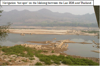
| Started condition surveys for navigation
improvement of ‘hot spots’ between Luang Prabang
and Pakse”. |
Navigation improvement plans. Detailed engineering charts of the rapids. Detailed design for manufacturing and installing buoys and beacons. Similar condition surveys between the Cambodia border and Can Tho Port in Viet Nam. |
| Facilitated negotiations on the draft Waterway Transportation Agreement between Cambodia and Viet Nam | Legal framework for Cross-border Navigation between Cambodia and Viet Nam (early 2008). |
| Better appreciation of the need to establish a legal framework for cross-border Mekong navigation. |
Component 2: Legal framework for cross-border navigation
This section of the programme works on overcoming the non-physical barriers to cross-border navigation and trade, for example through diversifying existing navigation agreements.
Existing agreements include:
2000 Upper Mekong-Lancang Agreement and Protocols
- between China, Myanmar, Lao PDR, and Thailand
1995 MRC Agreement, article 9, Freedom of Navigation
- between Cambodia, Lao PDR, Thailand and Viet Nam
1998 Bilateral Agreement on Water Transportation
- between Cambodia and Viet Nam (work on the protocols ongoing)
Programme experts provide advice on establishing guidelines to govern matters such as who will pay for the dredging that is required to improve navigation channels. The ultimate aim is to create a harmonised legal and operational framework to guarantee freedom of navigation, assist negotiations and mediation, and provide support schemes to enforce common rules
| Component 2 Achievements | Next Actions in Component |
| Setting up a study for a Legal Framework for Cross-Border Navigation between Lao PDR and Thailand downstream of Luang Prabang. | The study is conducted, ready to establish a Legal Framework |
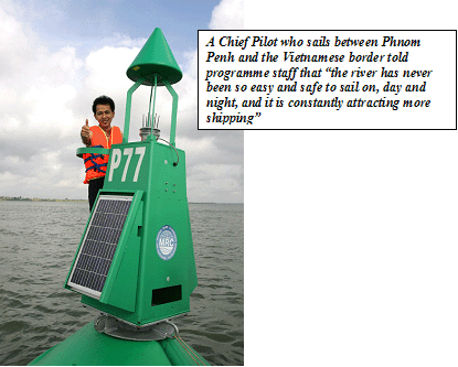
| The river between Phnom Penh Port and the Cambodia-Viet Nam border is now fully fitted with buoys and beacons, providing 24-hour safe navigation. |
Component 3: Traffic safety and environmental sustainability
Key issues:
- Accidents (loss of life/cargo)
Reducing accidents in ports, on the vessels and on the waterways - Physical barriers
Removing physical and non-physical obstacles to navigation taking into account environmental and social aspects - Pollution
Making Mekong navigation green
This component produces aids to navigation, is helping the Member States harmonise rules and systems, and is formulating management strategies for accident prevention, including wrecks and pollution incidents. Staff are conducting environmental impact assessments and training courses to help draw up contingency plans for potential disasters.
| Next Actions in Component |
| Follow-up on maintenance and operational use of the navaids + warranty check |
| Following the Condition Surveys, manufacturing and installing Aids to Navigation: on dangerous areas between Luang Prabang and Pakse in the Lao PDR and Thailand, from Cambodia-Viet Nam border to Can Tho Port |
| Risk for oil spills and other navigation-related hazards in ports and along waterways analysed |
Component 4: Information, promotion and coordination
Tidal
stations will inform oncoming vessels of the available water
depth in the river
- Waterborne transportation is still not widely regarded as an integral link in the regional transport system
- Operational and statistical information on river transport is lacking
Key issues:
This component makes use of the MRC's Mekong River Information System to river users plan their activities and help ensure safety. River level monitoring data is passed on to boat skippers and the relevant authorities in a digestible format. The programme works hard to promote private investment in the Mekong and its tributaries by demonstrating the advantages of river transport and co-ordinating with partners.
| Component Achievements | Next Actions in Component |
| Development of the Management Information System (MIS) Phase II under way. | To get MIS Phase II installed and running through vessel control or automatic identification system. |
| Install two tidal monitoring stations at the Mekong and Bassac Estuaries. The stations will notify incoming and outgoing ships of the exact water levels at the river entrances. | |
| Promotion of cruise shipping (sea-going and
river cruises). Respond to requests by shipping companies and cruise operators. Help ministries to attract these businesses. Promote Mekong shipping at specialised cruise fairs. |
|
| China has agreed to cooperate with MRC on a joint navigation improvement project for a condition survey between Houei Say and Luang Prabang with the eventual aim of installing navigational aids. |
Component 5: Institutional development
This component ensures national ownership and develops national capacity in the navigation sector. Its main tasks are to:
- Establish a management structure and select national navigation coordinators in each MRC member country;
- Form a regional advisory board and thematic Navigation Working Groups;
- Coordinate activities with partners such as the MRC Dialogue Partners, development banks and international financial institutions, international organisations and civil society;
- Create links with the private sector;
- Work closely with programme and potential donors;
- Ad hoc interventions.
Three implementation phases have been planned:
- A Preparatory Phase lasting 15 months;
- The Implementation Phase up to year 6;
- Preparations for future steps are to be decided during year 6.
This component has contributed to many of the achievements listed under the other parts of the programme, including:
- Master Plan for Mekong Navigation in Cambodia completed;
- River Channel Studies: Technical Feasibility Study on channel dredging in Tonle Sap Lake (on-going);
- A legal study for the development and implementation of Freedom of Navigation prepared, including a new draft protocol between Cambodia and Viet Nam (ongoing);
- Operational aids to navigation system between Phnom Penh Port and the Vietnamese border under implementation;
- Management Information System for the Port of Phnom Penh (First Phase completed);
- Establishment and functioning of the Navigation Advisory Body completed;
- Assignment and functioning of the National Navigation Coordinators completed.
In Short
The MRC Navigation Programme is squarely founded on direct results
and long-term efficiency.
The Navigation Programme will solve many existing cross-border issues and shall also anticipate future cross-border problems such as transboundary pollution.
The Navigation Programme is designed to ensure that this sector is being developed in an environmentally sound and socially just manner.
The MRC is the only regional organisation with a clear mandate to manage, assist in developing, and monitor cross-border waterborne transport.
Programme Budget
The total budget for the programme from 2006-2010 is US$19.6
million, of which over a third is provided by Belgium.
 Top
TopChoose a newsletter: