

| What is LTBP? | |||||||||||||||||||||||||||||||||||||||||||||||||||||||||
| Overview | |||||||||||||||||||||||||||||||||||||||||||||||||||||||||
| Participants | |||||||||||||||||||||||||||||||||||||||||||||||||||||||||
| Regional Offices | |||||||||||||||||||||||||||||||||||||||||||||||||||||||||
| Features: | |||||||||||||||||||||||||||||||||||||||||||||||||||||||||
| Calendar | |||||||||||||||||||||||||||||||||||||||||||||||||||||||||
| Photo Gallery | |||||||||||||||||||||||||||||||||||||||||||||||||||||||||
| Publications | |||||||||||||||||||||||||||||||||||||||||||||||||||||||||
| Programmes: | |||||||||||||||||||||||||||||||||||||||||||||||||||||||||
|
| Biodiversity |
| Environmental Edu. |
| Fishing Practices |
| Geogr. Info. Syst. |
| Pollution |
| Sedimentation |
| Socio-economics |
| Training |
Processes: |
| Legal Convention |
| Strat. Action Prog. |
Management: |
| Reg. Co-ordination |
Projects: |
| Nyanza Course |
| Uvira Renovations |
| World Environ. Day |
Administration: | Project Resources | | ||||||||||||||||||||||||
The Land
Lake Tanganyika receives its waters from rivers draining quarter of a million square kilometres of the surrounding countries. Many rivers enter the lake, but only one flows out, the Lukuga.
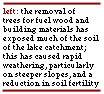
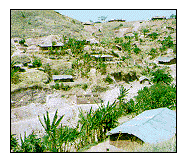 The large volume of the lake means that materials carried in from the land accumulate steadily and are removed only very slowly. The basins of some large in-flowing rivers, such as the Malagarasi and the Rusizi, contain much fertile, agricultural land. Clearing and tilling of the soil enables natural weathering to remove the topsoil to the lake where it joins fertilisers or insecticides washed from the catchment areas. Natural erosion has occurred since the creation of the lake, but the increase in demand for food has greatly accelerated the erosion rate in recent years.
 Urbanisation is a newer phenomenon that creates a different set of threats; sewage, household and industrial waste find their way into water courses and ultimately into the lake. These unwanted products are slowly distributed throughout the lake by wind-driven currents. What begins as a problem for an individual area may eventually affect the lake waters of all riparian countries.
|| Home ||
| Previous: Page 2 of 7 | Next: Page 4 of 7 |
