

| What is LTBP? | ||||||||||||||||||||||||||||||||||||||||||||||||||||||||||||||||||||||||
| Overview | ||||||||||||||||||||||||||||||||||||||||||||||||||||||||||||||||||||||||
| Participants | ||||||||||||||||||||||||||||||||||||||||||||||||||||||||||||||||||||||||
| Regional Offices | ||||||||||||||||||||||||||||||||||||||||||||||||||||||||||||||||||||||||
| Features: | ||||||||||||||||||||||||||||||||||||||||||||||||||||||||||||||||||||||||
| Calendar | ||||||||||||||||||||||||||||||||||||||||||||||||||||||||||||||||||||||||
| Photo Gallery | ||||||||||||||||||||||||||||||||||||||||||||||||||||||||||||||||||||||||
| Publications | ||||||||||||||||||||||||||||||||||||||||||||||||||||||||||||||||||||||||
| Programmes: | ||||||||||||||||||||||||||||||||||||||||||||||||||||||||||||||||||||||||
|
| Biodiversity |
| Environmental Edu. |
| Fishing Practices |
| Geogr. Info. Syst. |
| Pollution |
| Sedimentation |
| Circulation Model |
| Cruise Photos |
| Databases |
| Participants |
| Publications |
| Socio-economics |
| Training |
Processes: |
| Legal Convention |
| Strat. Action Prog. |
Management: |
| Reg. Co-ordination |
Projects: |
| Nyanza Course |
| Uvira Renovations |
| World Environ. Day |
Administration: | Project Resources | | |||||||||||||||||||||||||||||
|
The recent increase in deforestation in the catchment of Lake Tanganyika has often been assumed to have caused increase soil erosion and that the rivers carry this sediment load in increasing quantities downstream to the lake. The perception has been that the input of higher than usual amounts of suspended matter into the lake is a primary threat to the biodiversity of the lake which evolved there over many millennia of relatively low input of suspended matter. This perception was supported by very little empirical evidence. The Sedimentation Special Study (SedSS) set out to provide evidence as to whether this was, indeed, the case.
The SedSS set out to try and understand the links between catchment factors which affect erosion (rainfall, vegetation, slope, soil etc.), to understand how and in what quantity these erosional materials are transported to the lake and to attempt to understand their impacts on the lake ecosystem. 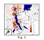 The study also attempted to examine recent changes to this process in order to link the impact on catchment landscapes caused by increased anthropogenic impact in these areas.
A catchment-wide model of erosion has been produced which highlights the areas where currently erosion is high as well as estimating how much of the eroded material is carried to the lake (as opposed to being redeposited within the catchment). Fig 1. shows a summary of that study where regions showing variation of surface erosion within the catchment and highlights 3 areas within the catchment of particularly high erosion where further studies have been suggested. The high erosion on the steep sloping areas of Burundi and northern DRC can also be noted. Most products of surface erosion that impact on the lake are carried by the rivers entering the lake. Prior to the commencement of the project the infrastructure of river gauging in all 4 riparian countries had completely broken down. This was due to a number of causes included lack of funding, lack of replacement equipment, lack of transport and regional insecurity. At that time there was not a single gauging station operational on the rivers of the Lake Tanganyika catchment. In the project we now have a total of 18 operational gauging stations sited on rivers close to the point that they enter the lake. |
|| Home ||
| Next : Page 2 of 3 |
