

| What is LTBP? | ||||||||||||||||||||||||||||||||||||||||||||||||||||||||||||||||||||||||
| Overview | ||||||||||||||||||||||||||||||||||||||||||||||||||||||||||||||||||||||||
| Participants | ||||||||||||||||||||||||||||||||||||||||||||||||||||||||||||||||||||||||
| Regional Offices | ||||||||||||||||||||||||||||||||||||||||||||||||||||||||||||||||||||||||
| Features: | ||||||||||||||||||||||||||||||||||||||||||||||||||||||||||||||||||||||||
| Calendar | ||||||||||||||||||||||||||||||||||||||||||||||||||||||||||||||||||||||||
| Photo Gallery | ||||||||||||||||||||||||||||||||||||||||||||||||||||||||||||||||||||||||
| Publications | ||||||||||||||||||||||||||||||||||||||||||||||||||||||||||||||||||||||||
| Programmes: | ||||||||||||||||||||||||||||||||||||||||||||||||||||||||||||||||||||||||
|
| Biodiversity |
| Environmental Edu. |
| Fishing Practices |
| Geogr. Info. Syst. |
| Pollution |
| Sedimentation |
| Circulation Model |
| Cruise Photos |
| Databases |
| Participants |
| Publications |
| Socio-economics |
| Training |
Processes: |
| Legal Convention |
| Strat. Action Prog. |
Management: |
| Reg. Co-ordination |
Projects: |
| Nyanza Course |
| Uvira Renovations |
| World Environ. Day |
Administration: | Project Resources | | |||||||||||||||||||||||||||||
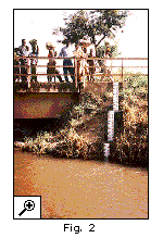 These stations provide data on a regular (usually daily) basis of river water levels and also enable the teams to measure river discharge and suspended sediment load on a less frequent (usually every 2 weekly) basis. Rivers are being gauged in all 4 riparian countries and constitute a variety of river types (from small fast-flowing streams to large rivers that enter the lake after meandering through low-lying areas). We are endeavouring that this network of gauged rivers be a core part of the future monitoring programme and that data can be shared between riparian countries who will share rivers with similar characteristics to the limited number which are being gauged (Fig. 2). Clearly the future monitoring of river flow and sediment discharge will be crucial in understanding the dynamics of the links between activities in the catchment and the lake. The relevance of these data go beyond the primary objectives of the Lake Tanganyika Biodiversity Project since they have the added value of providing key data for water managers and provide the raw data on catchment erosion patterns and any to monitor soil conservation measures. Long-term river monitoring at selected sites can provide a unique historical record of catchment processes. There is little historical data on changing rate of erosion within the catchment and most observations of increased input of suspended matter into the lake are anecdotal. The coring effort conducted by the project was able to address this. We have conducted a high resolution paleolimnological study of cores from a series of deltas along the eastern side of Lake Tanganyika, in order to document changes in catchment areas and lake sedimentology and ecology over the past several centuries. Our objective was to determine probable linkages between catchment and lake processes, and to assess the likelihood that ecological change in Lake Tanganyika has been influenced by land use practices, in particular by widespread conversion of woodland to subsistence agricultural lands. During a major research cruise in 1998 we collected an extensive suite of cores from seven deltas along the coastlines of Tanzania and Burundi. Cores from six of these deltas (Lubulungu, Kabesi, Nyasanga/Kahama, Mwamgongo, all in Tanzania, and Nyamuseni and Karonge/Kirasa in Burundi) were studied for geochronology, sedimentology, paleontology and geochemistry. |
|| Home ||
| Previous: Page 1 of 3 | Next : Page 3 of 3 |
