

| What is LTBP? | |||||||||||||||||||||||||||||||||||||||||||||||||||||||||||||||||||||||||||
| Overview | |||||||||||||||||||||||||||||||||||||||||||||||||||||||||||||||||||||||||||
| Participants | |||||||||||||||||||||||||||||||||||||||||||||||||||||||||||||||||||||||||||
| Regional Offices | |||||||||||||||||||||||||||||||||||||||||||||||||||||||||||||||||||||||||||
| Features: | |||||||||||||||||||||||||||||||||||||||||||||||||||||||||||||||||||||||||||
| Calendar | |||||||||||||||||||||||||||||||||||||||||||||||||||||||||||||||||||||||||||
| Photo Gallery | |||||||||||||||||||||||||||||||||||||||||||||||||||||||||||||||||||||||||||
| Publications | |||||||||||||||||||||||||||||||||||||||||||||||||||||||||||||||||||||||||||
| Programmes: | |||||||||||||||||||||||||||||||||||||||||||||||||||||||||||||||||||||||||||
|
| Biodiversity |
| Environmental Edu. |
| Fishing Practices |
| Geogr. Info. Syst. |
| Help Desk |
| LARST |
| Newsletter |
| Metadata |
| Participants |
| Publications |
| Pollution |
| Sedimentation |
| Socio-economics |
| Training |
Processes: |
| Legal Convention |
| Strat. Action Prog. |
Management: |
| Reg. Co-ordination |
Projects: |
| Nyanza Course |
| Uvira Renovations |
| World Environ. Day |
Administration: | Project Resources | | ||||||||||||||||||||||||||||||
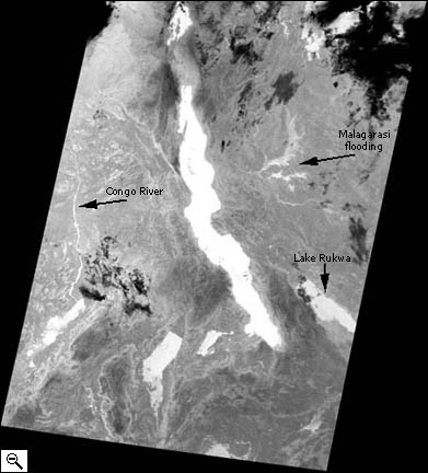 AVHHR image (infrared Channel #3) of Lake Tanganyika in June 1998. Note the large pale (cold) areas in the Malagarasi drainage where flooding is occurring, the other lakes in the region, and the Congo river in the west of the image. |
|| Home ||
| Back |
