1.2 BASIC TOPOGRAPHIC
AND GEOLOGIC FEATURES
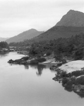
• The present-day landscapes of the Mekong River basin are very diverse,
ranging from the rugged mountains, deep valleys and plateaus at high elevations,
down to the broad low-lying flat river valleys, coastal plains and river
deltas of the lower Mekong basin and along the South China Sea.
• The geological and topographic features for both the Mekong River
Basin and the Southeast Asian mainland have resulted from a long and complex
geological history that included the plate tectonic movements resulting
from the "collision" of India and Asia about 50 million years
ago and led to the patterns of mountain ranges, plateaus and other geologic
and topographic features of today.
• These tectonic movements created the fan-shaped topography of Southeast
Asia, where the mountain ranges resemble the ribs of a fan separated by
the deep valleys carved by the Irrawaddy, Salween, Mekong, Yangtze and
Red Rivers.
• Interspersed into this fan-shaped pattern are plateaus at various
altitudes. Some of the most distinct plateaus in the vicinity of the Mekong
River basin are the Korat Plateau of Thailand, and the Bolovens Plateau
of Lao PDR.
 Mainland
Southeast Asia represents a geological jigsaw puzzle with the pieces made
up of ancient blocks of geological land surfaces or 'terranes', relatively
young mountain ranges and recent alluvial plains. Much of the present-day
topography is a result of the 'under-thrusting' of the Indian subcontinent
under the crust of the Asian continent which created the Himalayas and
uplifted the Tibetan plateau.
Mainland
Southeast Asia represents a geological jigsaw puzzle with the pieces made
up of ancient blocks of geological land surfaces or 'terranes', relatively
young mountain ranges and recent alluvial plains. Much of the present-day
topography is a result of the 'under-thrusting' of the Indian subcontinent
under the crust of the Asian continent which created the Himalayas and
uplifted the Tibetan plateau.
In the middle reaches of the Mekong basin, highland areas have been affected
by earthquakes resulting from the shear stress of tectonic movements.
Toward the south and southeast, tectonic forces have displaced and shifted
the ancient blocks, uplifted and folded younger geological strata of sedimentary
rock, and created depressions and lowlands that now act as traps for sedimentation
by the present-day river network. The enormous river erosion and deposition
process of today's Mekong River has been operating over a long period
of time, leading to stream capture of neighbouring watersheds, which has
resulted in either enlargement or reduction of the catchment area of the
Mekong.
The Mekong River Basin is part of the Southeast Asian landmass. The continental
portion of the Mekong basin's landscape has many distinct topographic
features extending from the highest elevations of the Himalayas and the
Tibetan Plateau, south and east to the shores of the South China Sea and
the Gulf of Thailand. The present day features of the basin's landscape
were created to a large extent by the massive tectonic movements of three
major portions of the Earth's crust; the Eurasian, Indian-Australian,
and Pacific plates. The Mekong basin, as part of this diverse Southeast
Asian landmass, has been subjected over long periods of time to geologic
activities such as faulting, folding, uplifting, and volcanic activity.
In more recent geologic time the landscapes of the Mekong basin were strongly
influenced by erosion and deposition and other climatic and river related
processes.
 Topography
of the mainland portion of Southeast Asia Topography
of the mainland portion of Southeast AsiaThis digital elevation model provides a colour-coded representation of topographic features. Lowland areas appear in green; hilly and mountainous terrain appears in yellow; and high-altitude and alpine terrains appear in brown and light gray, respectively. Source: NOAA Globe Project [www.ngdc.noaa.gov] |
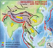 Geological
evolution and tectonics of East and Southeast Asia Geological
evolution and tectonics of East and Southeast AsiaThis tectonic model of Asia shows the directional movement of tectonic plates (yellow arrows); major plate margins and subduction zones (red lines with arrowsheads); and major tectonic fault systems (black lines). The latter two are potential zones of earthquakes. The area of the Mekong basin generally experiences a south-eastward movement as a result of the Indian subcontinent's collision with Asia. credit: Tapponnier |
The most important geologic process that
is responsible for creating the major geologic features of Southeast Asia
was the collision between the tectonic plates of the Indian subcontinent
and Eurasia. This process that began about 50 million years ago and continues
to the present day.
Although the mainland as a whole is similar in a geological sense, its
specific geologic and topographic features and the time periods of mountain-building
(orogenic) activity differ. The mainland portion of Southeast Asia is
characterized by a series of generally north-south-trending mountain ranges
separated by a number of major river valleys and their associated deltas.
In many ways these ranges resemble ribs in a fan, that are separated by
deep valleys carved by the process of river erosin. Mainland Southeast
Asia is characterized by a series of generally north-south-trending mountain
ranges separated by several major river valleys and their associated deltas.
Three primary ranges fan out southward from the southeastern corner of
the Plateau of Tibet, where they are tightly spaced. A major, S-shaped
branch of this system extends through the entire western margin of Myanmar.
Another major mountain system extends along a straight north-south axis
from eastern Myanmar east of the Salween River through northwestern Thailand
toward the Malay Peninsula. It consists of a series of elongated blocks
that were pushed upward from tectonic activity, rather than one continuous
mountain ridge. The altitudes of the mountains are more than 2,500 metres
near the Chinese border in the north and they decrease to below 1,200
metres through the Malayan Peninsula in the south. Much of the catchment
area of the Mekong River belongs to this system.
The easternmost chain of mountains on the mainland is the Truong Son Mountains
in Lao PDR and Viet Nam. This mountain chain forms several nearly straight
ranges that trend northwest to southeast. Their eastern slopes rise abruptly
from the South China Sea while more gradual slopes prevail toward the
Mekong basin in the west.
The fan-shaped pattern of the three major mountain ranges is interrupted
in several areas by ancient blocks that were pushed upward by tectonic
forces along fault lines or by large flows of lava. Today, these geologically
very old massifs form the two prominent plateaus found in the region adjacent
to the Mekong basin. The largest by far, is the Korat Plateau in eastern
Thailand and west-central Lao PDR. The plateau itself is only 100 meters
above the floodplains of the surrounding rivers, but the hills along its
perimeter range from 200 to 700 metres. The main drainage for the Korat
plateau region is eastward through the Mun River tributary of the Mekong.
 |
 |
In contrast, the Bolovens Plateau of southern
Lao PDR more than 1,500 metre above sea level. It is composed of basaltic
rock formed by great lava flows when tectonic movement stressed the Earth's
crust more than a million years ago. The Bolovens plateau drains south
west through the Se Done River and other smaller tributaries of the Mekong.
From the perspective of the regions geological history, the river related
lowland areas comprise the youngest of the large scale physiographic features
of mainland Southeast Asia. There are two primary lowlands environments.
The first includes the broad river valleys that extend seaward from the
northern uplands. The second lowland feature so characteristic of Southeast
Asia coastal landscapes is the vast deltas that form at the mouth of the
Mekong and other large river systems. The alluvial sediments found in
the broad river valleys and deltas allow intense cultivation and support
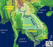
dense human population. The largest coastal lowland is that of the Mekong
River. The area encompasses most of Cambodia and southern Viet Nam.
When the geographic sectors of the Mekong River from the delta to the
Tibetan Plateau are considered, it becomes possible to gain an insight
into the incredible complexity of the river's physical environment. It
is this environment that supports the Mekong basin's biological diversity
as well as the cultures and economies of the Mekong basin. The more specific
details of the physical environments of the Mekong River and its basin
can be better understood when divided into three geographical sectors:
• The upper catchment area
• The middle reaches
• The lower reaches and delta
The Mekong River:
an introductory short video.
Click on the image to view the
video clip