1.3 THE UPPER CATCHMENT AREA
• The source of the Mekong is located on the Tibetan Plateau or "Roof of the World" at 5,000 meters elevation. Other important rivers of Southeast Asia also begin in this region.• The catchment basin of the Mekong head waters is generally very narrow; with differences in local relief and altitude exceeding several thousand meters.
• Southeast of the Tibetan plateau is the "Three Rivers Areas" exhibiting a very rugged terrain with high, north-south trending mountain ranges, steep slopes, and the deeply incised, closely spaced valley floors of the Salween, Mekong and Yangtze rivers.
• The area has considerable potential for hydropower development; some are already realized or under construction in Yunnan, China
The Mekong River originates on the Tibetan Plateau often referred to as the "Roof of the World." It is the highest and largest plateau on earth, with an average elevation of about 5,000 metres. Some of the world's largest rivers drain from this plateau. The Indus (Gar) drains the southwest area, the Brahmaputra (Yarlung Tsangpo) drains the southern and southeastern area, whereas the Salween (Nu), Mekong (Lancang) and Yangtze (Jinsha) and Yellow (Huang) rivers drain the central and eastern areas. More specifically, the source of the Mekong is in the Chamdo region; a tectonically complex area having many characteristics of a mature basin and range topography with 1,000 to 1,800 ms of relief.
The Mekong begins its journey to the South China Sea as the Dza Chu River. Tibetans divide the Dza Chu into two branches; the white or Dzakar Chu and the black or Dzanak Chu. The Dzanak Chu is known as the traditional Northwest Branch near the Langmug Pass. Following the exploration activities of several recent expeditions, the Chinese Academy of Science has determined that the Northern Branch seems to be the longer and therefore the 'true' source of the Mekong. This conclusion is supported by the examination of satellite image maps.
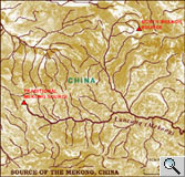 Satellite
image map of the source of the Mekong River on the Tibetan Plateau Satellite
image map of the source of the Mekong River on the Tibetan PlateauThis map is a combination of satellite image data (background) and cartographic annotation, including the river network. Mountainous terrain is shown in darker tones; the hilly portions of the Tibetan Plateau appear in brighter tones. The scale of the map is 1:600,000. A photo of the source of the Mekong is included. Source: The Tibet Map Institute [www.tibetmap.com] |
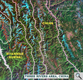 Landsat-7
ETM imagery of the Three Rivers area of the upper Salween, Mekong
and Yangzi river gorges in Yunnan Province, China Landsat-7
ETM imagery of the Three Rivers area of the upper Salween, Mekong
and Yangzi river gorges in Yunnan Province, ChinaIn the Landsat-7 ETM imagery, the different colours are indicative of land cover. For instance, snow covered terrain appears in light blue, and vegetation cover appears in pink, brown and green. The narrow river valleys are deeply incised into the rugged terrain; their orientation is from North to South. The image covers an area of approximately 185km by 250km. Source: US Geological Survey, EROS Data Center [landsat7.usgs.gov] |
The catchment area of the upper Mekong
is elongated, being only 30 to 40 km wide in some places, and lacks any
intermediate size tributaries. Thematic Mapper imagery, captured by Landsat-7
satellite, clearly reveal these very rugged terrain and unusual hydro-geographic
features. The elongated shape of the upper Mekong catchment means that
tributaries are short and tend to flow directly into the river. Nevertheless,
the catchment area comprises roughly 200,000 square kilometres, or one-fourth
of the Mekong basin's total area.
As the Mekong passes through the plateaus and mountains of southeastern
Tibet it comes into close proximity with other great drainage networks
of southern and eastern Asia in what is known as the Three Rivers area.
This very rugged area is characterized by the steep, parallel river gorges
of the Salween, Mekong and Yangtze that are separated by snow-capped mountain
ranges of up to 5000 metres. Even the valley floors of these rivers are
at elevations of 1000 to 1500 metres.
From the summit of Kawagebo (6,740 m) to the lowest place in the river
valley, the elevation change is greater that 5,000 m. The noted geographer,
T. L. Tregear describes it as: "Deep, steep-sided and heavily wooded
valleys with fast-flowing, unnavigable, and often unfordable rivers. Many
of these valleys are 5,000 feet deep and perhaps only 1/4 of a mile wide
at that height and within hailing distance. Yet it may demand a whole
day's strenuous journey to get from one side to the other. Occasional
swaying bamboo rope bridges, slung 500 feet above the rocky chasm, help
the traveller across" [Tregear, 1965: 265]. The region is one of
the richest in China in terms of landscape, biodiversity, and bio-resources.
Most of the hydro-electric development of the upper Mekong is likely to
be on the mainstream of the river. Little large scale irrigation development
is envisaged due to the incised nature of the topography.
Learn more about China's
Dachaoshan Dam project in the upper Mekong River.