1.4 THE MIDDLE REACHES
• Areas of highlands are the most visible physical features of the middle reaches often rising above 2,000 meters in altitude
• The Truong Son Mountains form the topographic 'spine' of Viet Nam. The Kontum Massif, contains the oldest rocks of Southeast Asia
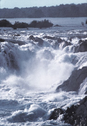
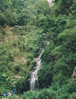
• Areas of hard resistant rocks cross the region creating rapids and water falls along the course of the river, that create obstacles to fish migration, pose hazards to navigation or make it impossible for larger vessels.
• Two important plateau areas are found in the middle reaches: the Bolovens Plateau which is composed of hard volcanic rock is the highest above sea level at 1,500 m, while the Korat Plateau is the largest in area but the lowest in elevation at 100 meters or less It is composed of sediments and eroded bedrock and surrounded by low mountain ranges that form a distinct rim around the Korat Plateau.
• The location of the waterfalls and other topographic or geologic features determine the choice of potential sites for dam construction and large scale hydropower resource exploitation.
 As
the Mekong flows out of the high mountain ranges of Yunnan, China, it
enters the middle reaches, of the basin. That lies within the peninsula.
This peninsula is made up of an ancient block of Precambrian rock that
extends from the continental shelf off the coast of Viet Nam westward
across Cambodia to the margins of the Himalayas.
As
the Mekong flows out of the high mountain ranges of Yunnan, China, it
enters the middle reaches, of the basin. That lies within the peninsula.
This peninsula is made up of an ancient block of Precambrian rock that
extends from the continental shelf off the coast of Viet Nam westward
across Cambodia to the margins of the Himalayas.
The northern highlands cover the section of the Mekong basin in Burma,
northern Thailand and northern Lao PDR. Several of the peaks rise to over
2,000 metres; typical heights are more than 600 metres above the valley
floors. The relief is abrupt and the clearing of much of the forest cover
leads to high rates of erosion. This area has been marked for a number
of large scale hydro electric power schemes. There is also a potential
inter-basin water diversion scheme from the Thai Kok and Ing tributaries
to the Chaophraya basin.
The eastern highlands are part of the Truong Son Mountains, one of the oldest portions of the Indochinese Peninsula. This mountain range forms the watershed between the Mekong River basin and the coast areas of the South China Sea. It extends in a gentle curve from northwest to southeast. Its highest peak, Mount Linh, is at 2,598 m. The geologically complex range consists mainly of limestones, sandstones, granites, and gneisses in the north.
In the south, folded crystalline rocks are covered in several places by basaltic lava flows. These basalts have formed impressive plateaus; the most notable are the Bolovens Plateau in southern Lao PDR and the Kontum Massif and the Dac Lac Plateau in southern Viet Nam. Precambrian granites in the ancient massif are believed to be some of the oldest rocks in Southeast Asia.
 The
Korat Plateau is a saucer-shaped tableland of northeastern Thailand. It
occupies an area of more than 150,000 square km and it is generally situated
100 to 200 metre above sea level and slopes towards the southeast. Much
of the plateau is drained by the Chi and Mun Rivers and by the Mekong
River to the north and east along the Laotian border. The Phetchabun,
Phang Hoei and Phanom Dong Rak ranges form a distinct rim-shaped ridge
along the western and southern side of the plateau (see topography map)
and, in part, constitute the natural boundary between Thailand and Cambodia.
The
Korat Plateau is a saucer-shaped tableland of northeastern Thailand. It
occupies an area of more than 150,000 square km and it is generally situated
100 to 200 metre above sea level and slopes towards the southeast. Much
of the plateau is drained by the Chi and Mun Rivers and by the Mekong
River to the north and east along the Laotian border. The Phetchabun,
Phang Hoei and Phanom Dong Rak ranges form a distinct rim-shaped ridge
along the western and southern side of the plateau (see topography map)
and, in part, constitute the natural boundary between Thailand and Cambodia.
The interior of the Korat Plateau consists of low hills and small lakes.
The impermeable soils are flooded during the rainy season from April to
November and parched during the dry season. A radar image taken from the
American Space Shuttle illustrates eroded sections of the plateau lands
and layers of sedimentary rocks bordering the Phang Hoei range in northeastern
Thailand.
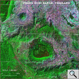 Satellite
image of typical terrain features of the Phang Hoei Range, northeastern
Korat Plateau area, Thailand. The area is 50 x 50 km Satellite
image of typical terrain features of the Phang Hoei Range, northeastern
Korat Plateau area, Thailand. The area is 50 x 50 km"This image shows the dramatic landscape in the Phang Hoei Range of north central Thailand, about 40 kilometers northeast of the city of Lom Sak. The plateau, shown in green near the center, is the area of Phu Kradung National Park. It is is a remnant of a once larger plateau, another portion of which is seen to the northwest. The plateaus have been dissected by water erosion over thousands of years. Forest areas are green on the image; agricultural areas and settlements are red and blue." Source: NASA/JPL |
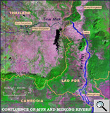 Satellite
imagery of the southeastern Korat Plateau near the confluence of
the Mun River and Mekong at the Thailand, Lao and Cambodian border Satellite
imagery of the southeastern Korat Plateau near the confluence of
the Mun River and Mekong at the Thailand, Lao and Cambodian borderThe scene shows lush vegetation growth (green), water reservoirs (black) and water surfaces appear in blue. The natural vegetation cover is shown in green. Harvested fields and fallow areas appear in pink colour, providing a good indication of land use patterns and agricultural land use. Source: US Geological Survey, EROS Data Center |
The present-day appearance of the plateau's surface
was at least partly created by extensive wind-born sedimentation that
occurred during the relatively recent dry glacial periods. However, hidden
underneath this relatively flat surface is a bedrock topography with old
and often deeply incised valleys that have been filled with Quaternary
deposits and sometimes obstructed by lava flows. The original drainage
pattern of the Mun River and its tributaries appears to have been part
of the Chao Phraya drainage in the southwest at an earlier point in time.
Tectonic movement over the past million years has tilted the plateau toward
the southeast, allowing the modern Mekong to capture the drainage of the
Mun River. The Landsat-7 image shows the southeastern portion of the Korat
Plateau. The Mun River and its tributaries appear toward the top of the
image near the confluence with the Mekong.
 The
boundary of the Phonon Dong Rak Range is clearly marked by green forest
vegetation; the braided stream pattern of the Khone Falls area is visible
in the southeastern corner, whereas small portions of the high Bolovens
Plateau appear in the northeastern corner of the image.
The
boundary of the Phonon Dong Rak Range is clearly marked by green forest
vegetation; the braided stream pattern of the Khone Falls area is visible
in the southeastern corner, whereas small portions of the high Bolovens
Plateau appear in the northeastern corner of the image.
Over in the past 20 years or so the hilly and mountainous topography in
the middle reaches of the Mekong has received much attention by resource
managers, politicians, engineers and environmentalists, as it offers considerable
potential for the construction of dams, reservoirs, and hydro-electric
power generation. Areas of actual or planned dam sites are mainly found
along the tributaries of the Mekong in Thailand and in Lao DDR. Already
several large dams have been constructed in the Mun River catchment. The
Lam Pao Reservoir is one example. The shoreline of the reservoir as shown
on this image, reflects the local topography and drainage patterns. The
size of the reservoir clearly shows that large areas are affected by the
construction and operation of these reservoirs.
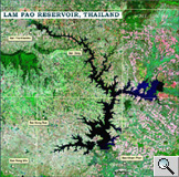 Image
of the Lam Pao Reservoir, central Korat Plateau, Thailand Image
of the Lam Pao Reservoir, central Korat Plateau, ThailandThe reservoir appears as a large dark surface in the centre of the image. The irregular outline of the reservoir indicates that the water actually fills on old river valley and that of smaller tributaries Source: NASA |
Continuous river transport from the sea into the middle reaches of the Mekong basin is blocked chiefly by the barriers of the Khone Falls and other falls and rapids between Sâmbor and Pakse, Upstream uses of the river are, therefore limited to local river traffic.