1.5 THE LOWER REACHES AND DELTA REGIONS
• The Great Cambodian Plain is a geologically recent depression that "traps" the sediments of the Mekong and those of its tributaries.
• The very flat and low-lying terrain has resulted in frequent course changes of the Mekong over time.
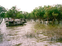
• Annual flooding during the monsoon season creates the floodplain of the Mekong, including extensive back-swamp areas.
• Flooding also causes the famous reversal of the flow of the Tonle Sap River causing it to drain north into the shallow Tonle Sap Lake and increasing its surface area, but not its depth, enormously.
• The flood plains contain occasional and fairly small old rock outcrops which often hint at an older land surface that, over time, has been covered by the sediments of the rivers.
• The present delta of the Mekong is located to the South of the "Four Arms" area at Phnom Penh.
• On its way to the sea, the branches of the Mekong River are marked by natural embankments, or levees, that partially flood during the rainy season, as do the adjacent lowlands of the delta.
• Coastal currents in the South China Sea shape the coast line and constantly redistribute the rich sediment load of the Mekong, particularly around the southern tip of Viet Nam.
 Downstream
of the Korat Plateau and to the west of the Truong Son Mountains, the
Mekong River flows over the Khone Falls and enters the Great Cambodian
Plain which is a broad, bowl-shaped area lying just above the mean sea
level. Geologically this sector of the Mekong basin is a structural depression
that has been filled with recent sediments. It is very young and very
flat. Because the region is so flat, seasonal backswamps are a frequent
occurrence. These are small water bodies that may or may not dry out in
any single year. They are natural depressions located close to the raised
natural embankments of the Mekong and its main tributaries. The ecological
function of backswamps is to take up some of the flood water during the
wet season peaks. Backswamps are flooded more regularly and earlier than
the rest of the floodplain. Backswamps form a major habitat for a number
of fish species and can serve as spawning grounds.
Downstream
of the Korat Plateau and to the west of the Truong Son Mountains, the
Mekong River flows over the Khone Falls and enters the Great Cambodian
Plain which is a broad, bowl-shaped area lying just above the mean sea
level. Geologically this sector of the Mekong basin is a structural depression
that has been filled with recent sediments. It is very young and very
flat. Because the region is so flat, seasonal backswamps are a frequent
occurrence. These are small water bodies that may or may not dry out in
any single year. They are natural depressions located close to the raised
natural embankments of the Mekong and its main tributaries. The ecological
function of backswamps is to take up some of the flood water during the
wet season peaks. Backswamps are flooded more regularly and earlier than
the rest of the floodplain. Backswamps form a major habitat for a number
of fish species and can serve as spawning grounds.
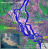 Map
of the Mekong entering the Great Cambodian Plain south of Khone Falls
at the Lao - Cambodian border Map
of the Mekong entering the Great Cambodian Plain south of Khone Falls
at the Lao - Cambodian borderThe area of the falls are marked by the braided river network in the center called Siphan Done. Source: Image Courtesy of Earth Sciences and Image Analysis Laboratory, NASA Johnson Space Center (http://eol.jsc.nasa.gov). |
 A
central feature of the lowland sector of the Mekong River is Southeast
Asia's largest freshwater lake, the Tonle Sap or Great Lake. In certain
ways, the Tonle Sap has characteristics that are similar to those of a
backswamp but on a much larger scale. The waters of the Tonle Sap, are
very shallow. The depth of the lake during the dry season is less than
three meters. During the monsoon season there is a massive inflow of water
by the Tonle Sap River causing widespread flooding, which results in a
four-fold increase of the lakes' surface during the wet season. The southern
floodplains of the Mekong and Tonle Sap system is bordered by the Dâmrei
(Elephant) and Krâvanh (Cardamom) mountains. Several tributaries
rise in these uplands.
A
central feature of the lowland sector of the Mekong River is Southeast
Asia's largest freshwater lake, the Tonle Sap or Great Lake. In certain
ways, the Tonle Sap has characteristics that are similar to those of a
backswamp but on a much larger scale. The waters of the Tonle Sap, are
very shallow. The depth of the lake during the dry season is less than
three meters. During the monsoon season there is a massive inflow of water
by the Tonle Sap River causing widespread flooding, which results in a
four-fold increase of the lakes' surface during the wet season. The southern
floodplains of the Mekong and Tonle Sap system is bordered by the Dâmrei
(Elephant) and Krâvanh (Cardamom) mountains. Several tributaries
rise in these uplands.
The famous reversal of the flow direction of the Tonle Sap River between
the Great Lake and the Mekong during the peak of the annual flood season
is a very good indication of the subtle interplay between the water flow
and terrain conditions in the modern flood plain. The present course of
the lower Mekong resulted from changes that took place since the last
glacial period that ended about 10,000 years ago. At that time, the ocean
would have inundated the entire delta region, rising to its highest level
since the Miocene epoch some 5 million years ago, and allowing the river
to establish a more direct route to the sea During this time the mouth
and delta of the Mekong shifted from it's original position east of Phu
Quoc Island in the Gulf of Thailand to its present location that occupies
the entire southern tip of Viet Nam.
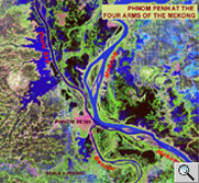 At
Phnom Penh the river divides into two main branches: the Mekong proper
and the Bassac. From this point onward much of the sediment load of the
Mekong is deposited into the relatively shallow waters of the South China
Sea to form the present day delta.
At
Phnom Penh the river divides into two main branches: the Mekong proper
and the Bassac. From this point onward much of the sediment load of the
Mekong is deposited into the relatively shallow waters of the South China
Sea to form the present day delta.
The delta extends over an area of about 65,000 square kilometres. Its
upper section, above Chau Doc (Chau Phu), has strong natural levees built
on either side of the river by accumulated deposits of silt with low;
wide and often poorly drained depressions extending beyond those embankments.
Its lower section is formed by the river mouths and by the area of active
sedimentation to the southwest. Here, the flooding is less extreme than
in the upper sections of the delta. An elaborate system of canals defines
the Vietnamese portion of the delta. Smaller seagoing vessels can sail
upstream as far as Phnom Penh, whereas vessels drawing almost 15 feet
can reach Kampong Cham during high water.
The very straight southeasterly orientation of the Mekong, Bassac and other arms of the delta may have followed an older fault system, known as the Mae Ping - Tonle Sap Fault line. Imagery taken from space provide bear witness of these very straight linear features that are clearly visible under both dry season and wet season conditions. Similar to the NW-SE orientation of the Song Ma Suture and the pronounced Red River Fault of Northern Viet Nam, these lines are testimony to the very active mountain building processes that have resulted from the collision of the Indian Subcontinent with the Asian landmass.
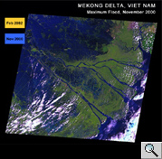 Landsat-7
ETM imagery of the Mekong delta, Viet Nam Landsat-7
ETM imagery of the Mekong delta, Viet NamThe Landsat-7 scenes were acquired on November 6, 2000 and February 13, 2002. The different colours are indicative of different land cover features. For instance, blue indicates water surfaces of the river; extensively flooded terrain (November), and the ocean. Green represents vegetation cover, including rice cultivation; brown and pink indicates bare soil during the dry season (February). Source: US Geological Survey, EROS Data Center |