2.3 RAINFALL PATTERNS AND TEMPERATURE VARIATIONS
• Weather vs. Climate present atmospheric conditions vs. long term and regular re-occurrence of average weather
• Monsoon climate - a tale of two cities: Ho Chi Minh City and Vientiane
• Small variation in average temperature over a year, high temperatures, and plentiful but seasonal rainfall
• Network of climatic observations is sparse; satellite imagery help to record weather conditions, rainfall, and airborne pollutants

There are some important definitions when it comes to
weather and climate. Weather is the day to day evolution of the atmosphere.
We experience it as wet or dry, warm or cold, windy or calm. Weather worries:
'Should I bring my umbrella to work today? On the other hand, the most
basic aspect of climate is the long term average of weather; it is what
we expect for a particular region at a particular time of year, for example,
hot and humid in Phnom Penh during the SW monsoon. Climate also includes
the range of possibilities, for example, the warmest and coldest temperature.
So, while the diagrams for Vientiane and for Ho Chi Minh City reveal little
about actual weather conditions in these two northern and southern locations,
they do show the main climatic characteristics over the course of the
year. Both cities are located on or near the Mekong at 171 meters and 19 meters
above mean sea level, respectively. The values for the mean rainfall and
temperature are shown on a monthly basis. Data collection goes back several
decades, and the values recorded here are long-term averages. They are
typical for tropical and subtropical climates of Asia.
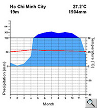 Climate
diagram of monthly averages for temperature and precipitation for
Ho Chi Minh City, located in the delta region of the lower Mekong
basin, Viet Nam and Vientiane, located in the highland region of the
lower Mekong basin, Lao PDR. Climate
diagram of monthly averages for temperature and precipitation for
Ho Chi Minh City, located in the delta region of the lower Mekong
basin, Viet Nam and Vientiane, located in the highland region of the
lower Mekong basin, Lao PDR.
Source: [www.klimadiagramme.de/Frame/indexeu.html]
|
The climate of the two cities is generally characterized
by relatively small annual temperature ranges, high temperatures, and
plentiful precipitation. In the case of subtropical Ho Chi Minh City,
the annual temperature range is less than five degrees; the mean daily
temperature is always above 25 degrees Celsius. They city receives rainfall
in excess of 1,900 mm; rainfall exceeds 100 mm in more than six months
during the year. However, as one moves further away from the equator,
a pronounced dry season sets in, usually in the low-sun "winter"
season. The highest temperatures generally occur at the end of this clear
spell, that is to say in May. Circulation of relatively warm and cold
air masses brings precipitation in the summer when warm, moist maritime
tropical air moves over land. In winter, cool, dry air invades southern
latitudes from the north, bringing a clearer period of variable length.
For Vientiane further to the north, the pattern is very similar; however,
there are some noticeable differences. The mean temperature range is larger,
reaching almost 10 degrees between the mean annual low of 21 degrees in
January and the high of almost 30 degrees Celsius in May. The rainfall
amount per year is slightly lower with 1,740 mm, mainly because Vientiane
is further away from the ocean, that is to say it experiences a somewhat
more continental climate at a more mountainous location than Ho Chi Minh
City.
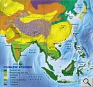 Main
climatic regions of Asia Main
climatic regions of Asia |
Thus the major influences on
the climate of the Mekong basin are its position in the subtropical latitudes
of mainland Southeast Asia and certain topographic features that affect
the distribution of precipitation. In May, the warm, humid air masses
of the southwest monsoon begin to flow northeastward over the region from
the Indian Ocean, depositing great quantities of rain. Rainfall reaches
a maximum in September. The wind pattern is reversed between November
and February. Then the circulation pattern of the northeast monsoon takes
over. A southwesterly flow brings cool, relatively dry air masses. These
result in a seasonably cooler climate for much of the region. The lighter
and drier winds of the northeast monsoon bring variable cloudiness, infrequent
precipitation, and lower humidity. In March and April, before the onset
of the southwest monsoon, the air masses appear to be more stagnant. This
is associated with a hot and dry intermonsoonal period. A typical situation
is captured in a MODIS satellite image of the lower Mekong basin, where
much of the northern region shows broken cloud cover, whereas dense, rain-bearing
clouds are collecting on the windward side of the mountain ranges in the
south. The dense cloud pattern of various tropical rainstorms over northern
Viet Nam and NW Cambodia are illustrated in a NOAA satellite image taken
on October 27, 2001.
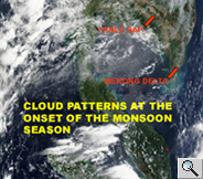 MODIS
satellite image (May 2002) of cloud patterns over mainland Southeast
Asia at the onset of the SW monsoon season. MODIS
satellite image (May 2002) of cloud patterns over mainland Southeast
Asia at the onset of the SW monsoon season.
Source: NASA |
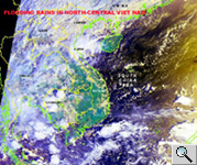 NOAA-15
AVHRR satellite image (October 27, 2001) of tropical rainstorms over
northern Viet Nam and NW Cambodia, at the end of the monsoon season. NOAA-15
AVHRR satellite image (October 27, 2001) of tropical rainstorms over
northern Viet Nam and NW Cambodia, at the end of the monsoon season.
Source: NOAA |
Most of the Mekong Basin receives
more than 1,500 mm of rain annually. Some areas receive two to three times
this amount. Experts have noted that there are generally few observations
with regard to climate in continental Southeast Asia (Nieuwolt 1981). Our understanding
of the monsoon has been hampered by the lack of physical and dynamic information
over the vast regions around the high mountains in Asia. However, data
collected by Earth observation satellites provides useful information
over space and time to improve our understanding of the monsoon circulation
and the global hydrologic cycle. The following animation graphically illustrates
the seasonal evolution of the Asian monsoon system during the course of
a year. It was created by averaging the data collected by the Global Environmental
Observation System (GEOS) over a five year period (1985-1989).
| Monsoon circulation
of wind and precipitation in Asia (still map & animation)
Source: NASA GOES Program |