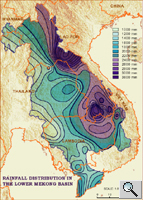
2.4 REGIONAL VARIATIONS
• Regional topography and altitude
has the greatest influence on rainfall patterns in the Mekong basin; many
areas receive more than 1,500 mm per year
• Higher precipitation on the windward side of mountain ranges during
SW monsoon
• Relatively drier conditions on the leeward side ("foehn"
effect)
• Upper Basin: relatively low rainfall, but more evenly distributed
over the year
• The highland regions of Lao PDR and Viet Nam receive much more
precipitation and contribute about 20% of the flow volume of the Mekong
• Hydropower potential and actual developments in China and Lao PDR
focus on areas with high relief energy and catchment areas with high precipitation
• The Khorat Plateau in Thailand is relatively dry
(< 1,500 mm per year), partly because of the "rain shadow"
effect
• Overall, there are no clear regional boundaries, however the extremes
range from short dry season and hot wet summers in the south to cold dry
winter and hot wet summers in the north.
 Apart
from the transitions from moderate to subtropical and tropical latitudes,
the differences between the climatic conditions in the Mekong basin are
determined to a considerable degree by topography. Especially in the Upper
Mekong, there are different climatic zones that are most well defined
by their altitude. They vary from the subtropical climates of the Yunnan
Plateau, to the cold, land-locked mountains and plateau of Tibet, at the
highest altitudes. Furthermore, the degree of exposure also plays a role.
Southern slopes receive more sunshine. Northern slopes receive less sunshine
and are in the shade more often. Likewise windward slopes with direct
exposure to moist ocean winds differ from leeward slopes, where the wind
and rain shadow result in drier conditions.
Apart
from the transitions from moderate to subtropical and tropical latitudes,
the differences between the climatic conditions in the Mekong basin are
determined to a considerable degree by topography. Especially in the Upper
Mekong, there are different climatic zones that are most well defined
by their altitude. They vary from the subtropical climates of the Yunnan
Plateau, to the cold, land-locked mountains and plateau of Tibet, at the
highest altitudes. Furthermore, the degree of exposure also plays a role.
Southern slopes receive more sunshine. Northern slopes receive less sunshine
and are in the shade more often. Likewise windward slopes with direct
exposure to moist ocean winds differ from leeward slopes, where the wind
and rain shadow result in drier conditions.
 This
mountain barrier effect may be encountered as part of the monsoon circulation
of Southeast Asia. The rain-bearing winds have a fairly constant direction.
They are being intercepted by north-south trending mountain ranges. In
these areas, it is not uncommon for rainfall to exceed 2,500 mm per year.
The rain shadow of these mountain ranges creates relatively dry areas,
where rainfall amounts to only 1,200 mm or less. In addition to the physical
isolation of the leeward slopes from the moisture-laden winds, the 'warm
wind', or foehn effect, also is found here. This occurs when a strong
wind traverses a mountain range and is deflected downward as a warm, dry,
gusty, erratic wind. The isolating barrier effect of the relief on the
climate is demonstrated most clearly in the interior regions where surrounding
mountains isolate the plateaus or valley floors from moisture-laden winds.
For example, rain-shadow effects occur along the western margins of the
basin and on the Korat Plateau.
This
mountain barrier effect may be encountered as part of the monsoon circulation
of Southeast Asia. The rain-bearing winds have a fairly constant direction.
They are being intercepted by north-south trending mountain ranges. In
these areas, it is not uncommon for rainfall to exceed 2,500 mm per year.
The rain shadow of these mountain ranges creates relatively dry areas,
where rainfall amounts to only 1,200 mm or less. In addition to the physical
isolation of the leeward slopes from the moisture-laden winds, the 'warm
wind', or foehn effect, also is found here. This occurs when a strong
wind traverses a mountain range and is deflected downward as a warm, dry,
gusty, erratic wind. The isolating barrier effect of the relief on the
climate is demonstrated most clearly in the interior regions where surrounding
mountains isolate the plateaus or valley floors from moisture-laden winds.
For example, rain-shadow effects occur along the western margins of the
basin and on the Korat Plateau.
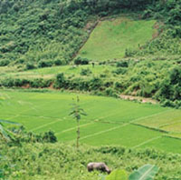
In the upper reaches of the Mekong, rainfall is significantly lower than
the average for the basin but the rain is more even throughout the year.
Snowmelt in the Himalayas and the Tibetan Plateau region leads to a spring
peak in the flow of the river in the upper reaches. During that time,
the lower reaches experience drier conditions. Agriculture in Yunnan province
of China is based on terraced wet rice farming and shifting cultivation.
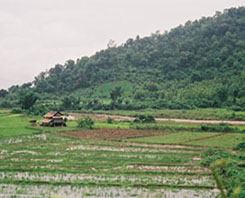
The highland areas on the western slopes of the Truong Son Mountains receive
plenty of rainfall. These highlands are also the most heavily forested
part of the basin and are rich in biodiversity. Several large hydropower
projects are planned in the Lao PDR and Vietnamese sections of this area,
and some of these entail diversion of river water to drier basins.
 |
 |
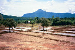
The Korat Plateau
is drained by the Chi and Mun River systems and by several smaller and
shorter tributaries that flow directly into the Mekong. The plateau is
the driest area of the Basin. Rainfall is under 1,500 mm per year, and
soil in this area does not retain the moisture very well. However, the
gentle topography has contributed to a relatively high population density
compared with the highland areas. Major water flood mitigation and irrigation
measures have been implemented or proposed for the area. There are some
concerns over these, because of problems related to soil salinization
and waterlogging problems. Another concern is downstream effect from the
diversion of water within the basin.
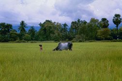
A small section of uplands marks the southwestern portion of the Mekong
Basin. It is drained by rivers that are flowing northward into the Great
Lake, and into the Tonle Sap and Bassac Rivers. Here, rainfall is above
average on the southern side of these uplands outside the basin, which
receive up to 5,000 mm per year. However, precipitation is lower on the
Mekong basin side which is in the shadow of the Cardamom and Elephant
hills; less than 2,000 mm is recorded here.
 |
 |