7. Impact of the 2005 flood - Country reports (cont')
7.4 Impact of the 2005 flood in Viet Nam (cont')
7.4.3 Overview of the impacts at National Level (Mekong River Basin)
The peak level in Tan Chau3 reached 4.53 m on 31st October 2005; this corresponds to a discharge of 21,900 m3/s. The highest tide occurred at Can Tho on 18th October 2005 with a water level of 1.95 m and in My Thuan on 20th October 2005 with a water level of 1.86 m. Local rainfall reached some 1500 mm compared to long-term annual rainfall 1600 mm. Maximum on-farm inundation depth was recorded at Moc Hoa station on 15th October 2005 with a level of 2.39 m. The rainy season came 15-20 days later than normal in the Delta, starting at the end of May 2005 and finishing at the end of November. The flood from upstream also came late in the Delta as the peak flood occurred by the end of October.
Nine provinces of the Vietnamese Mekong Delta (VMD) were affected by flooding. The flood can be divided into three inundation zones: deep inundation area (> 2m), average inundation area (1-2m) and little inundation area (<1m). The provinces of Dong Thap, An Giang and Long An (which belongs to the Vaico River Basin, but hydraulically is connected with the Mekong through lowlands and artificial connections) are classified as deep inundated provinces while other provinces were considered as average or mildly inundated ones. Figure 50 summarises the damage recorded in the Mekong Delta by provinces. The national 2005 flood report, established by the National Committee for Disaster Management does not mention any additional damage in the other areas. The Team therefore assumes that this table represents the summary of the damage caused by the 2005 flood in the Vietnamese part of the Mekong River Basin. In the Vietnamese Mekong Delta, the year 2005 was considered a "balanced" flood, even though 77 people died, some property was lost and damage of US$3.5 million was recorded. This was the least damaging year in the Delta since the 2000 flood. In 2005, the production of paddy reached 17.2 million tonnes and it was considered a successful year for crop production.

Source: Provincial Committees for Disaster
Management
Figure 50: Summary of damage in Viet Nam by 2005 flood, by provinces

Figure 51: Water levels and their relation
to levels of flooding.

Figure 52: Estimate of damage from the
2005 flood in US$.
Referring to the Tan Chau station, the ideal water level for a "nice" flood stands between 3.5 and 4.5 m. Above 4.5 m, it becomes a "serious" flood and damage other than natural erosion and accidents start to be recorded. Above 5 m, it is considered as a "dreadful" flood that capable of producing lot of casualties and generating heavy damage to infrastructure. If the water level is below 3.5 m, production of fish decreases, soil fertility is less, and downstream of the delta, soil cannot be washed and salinity increases. This is why year 2005 was considered as a "nice" flood, with benefits and little damage.
7.4.4 The affected areas
The team in charge of preparing the MRC Annual Flood Report 2005 visited two "affected" provinces: An Giang and Dong Thap. Meetings with the provincial and district authorities (with participation of the technical departments) were organised as well as field trips. Informal discussions with stakeholders provided us with a better understanding of the problems of flooding in the Mekong Delta and how this situation is tackled before, during and after the flood periods based on lessons learnt from the 2000 flood. Except in the Province of Long An, which is a special case as it is partly influenced by the Mekong and partly by the Vaico River, the provinces of An Giang and Dong Thap were considered as particularly affected by the flood in 2005; nevertheless, damage was more a normal consequence of water rising in the delta than actual flood damage due to an exceptional event.
In these two provinces, 45 to 50 people died from the flood in 2005, mainly due to accidents involving children falling into water (this figure may vary according to the interpretation of the concept "death by flood"). Damage to roads and infrastructure was caused by erosion. These structures are inundated every year whatever the level of the flood. Damage to agricultural production was very limited. The province of An Giang is one of the most annually exposed to flood in the delta. Figure 54 allows an interesting comparison between the damage generated by the "dreadful" 2000 flood, the heavy floods in 2001 and 2002 and damage normally sustained as a consequence of the annual rises in the water level in 2003, 2004 and 2005.
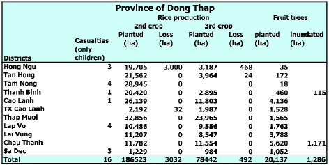
In the Province of Dong Thap, some analysed figures, broken down by district, show that major damage was due to annual erosion (See Figure 55). Damage to crops, which is a good indicator of the severity of the flood, was limited. The loss of the second crop was recorded only in the District of Hong Ngu, particularly in the low lands. This was most likely due to inadequate timing of the cropping period so the rice could not be harvested before the early flood.

Figure 53: The regions affected by flood
in Vietnam

Source: Provincial Disaster Management
Committee
Figure 54: Damage caused by flood over the past five years in
An Giang Province.
Source: Provincial Disaster Management
Committee
Figure 55: Damage caused by the 2005 flood in Dong Thap Province.
Figure 54: Damage caused by flood over the past five years in
An Giang Province.

Erosion is the major cause of damage generated by the rising water level in the Mekong Delta. This situation is dangerous for people and housing, damages infrastructure and reduces agricultural lands. Sedimentation also has adverse impacts, mainly by colmating the irrigation and drainage canals. The balance of erosionsedimentation is not well known, but infrastructure aimed at concentrating the flow in the mainstream could increase erosion as it increases the flow velocity.
_____________________
3ref. Ha Tien Datum
Choose a newsletter: