6. Summary of the 2008 country reports
6.4 Vietnam
General situation
Although water levels in the Mekong Delta at Tan Chau and Chau Doc exceeded alarm levels for considerable periods of the 2008 flood season1, flood damage in this part of the country was limited and less than that for a typical year. In fact over the year less than 70 ha of rice paddy was reported to have been damaged. The only significant inundation occurred in mid October as a result of spring tide conditions causing widespread but brief flood inundation in a number of delta provinces and Can Tho City, and in late November as a consequence of the intense rainfall linked to the passage of tropical storm Noul over the southern regions of Viet Nam.
In the Central Highlands, specifically in the upper Se San and Sre Pok river basins, a number of local flash floods occurred, with those of mid May, early August and late November being the most damaging. Generally, however, as in the Delta, 2008 was a year that saw the lowest levels of flood losses observed in recent years.
Flash flooding in the upper Se San basin
During the first half of August, at the same time that tropical storm Kammuri was passing over the northern regions of the Lower Mekong Basin, heavy rainfall occurred over parts of the Central Highlands, particularly in Kon Tum Province in the upper Se San basin, with as much as 355 mm observed in the 7 days between the 2nd and 8th of the month.
| Station | River basin | Rainfall (mm) |
| Mang Canh Sa Thay Dak Lay Pleiku Dak Mot Kon Plong Dak To Kon Tum |
Dak Bla Dak Bla Dak Bla Dak Bla Se San Se San Dak Takan Se San |
175 190 185 280 155 285 185 355 |
On the 7th in Dak Bla village and Kon Tum town flash flooding caused considerable damage to residential property, crops and infrastructure and included one death. Almost 100 ha of rice paddy were lost completely and 150 ha damaged, 8 rural bridges were damaged and total costs estimated to be VND 15.5 billion.
Flash flooding in the upper Sre Pok basin
During early May local monsoonal low pressure systems brought heavy rainfall to the upper Sre Pok basin and flash floods to Dak Nong province on the 11th, which resulted in four deaths. Later in the year in November tropical storm Noul caused further flash flooding and significant damage to 60 houses along with two further two deaths.
| Station | River basin | Rainfall (mm) |
| Buon Ma Thuot Buon Ho Giang Son Duc Xuyen Bridge 14 Krong Buk |
Sre Pok Sre Pok Sre Pok Sre Pok Sre Pok Sre Pok |
135 160 225 110 115 290 |
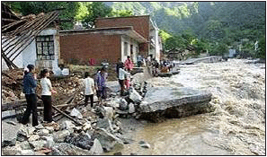
Figure 6.11 Typical flash flood conditions
in the Central
Highlands, indicating high flow velocities and considerable
erosive power. Landslides in the steep terrain add to the
hazard since they can block river channels. When they
collapse or are overtopped, a wave of floodwater is
released containing huge amounts of sediment and debris.
Flood damage and losses
Flood damage in the delta during 2008 was insignificant. In the upper Se San and Sre Pok though flash floods did occur with some loss of life, total damages were small compared to previous years. For example, during 2008 costs were estimated to be US$1 million, compared to US$51 million in 2007.
Lessons learnt
The benign flood conditions in 2008 in the delta served to emphasise the benefits of the annual Mekong flood with regard to agriculture fisheries and the environment. Although flood protection and mitigation measures both structural and non-structural continue to be implemented in the Delta, it is recognised that more needs to be done in the Central Highlands where flash flooding is a perennial hazard. By definition such events are extremely difficult to forecast, though by monitoring levels of catchment saturation, improving the accuracy both spatial and temporal of short term rainfall forecasts, mapping the most vulnerable areas and encouraging people not to live in them would serve to reduce the significant losses in terms of both property and lives that occur year in, year out. It is acknowledged that mitigating the impacts of flash floods in Viet Nam would be a considerable and very expensive challenge, not with standing the significant social challenges that exist and the fact that such floods occur throughout the country and are a major cause of loss of life. Although qualitatively the conditions that cause them are well understood the quantitative meteorological and hydrological thresholds that trigger them within various types of landscape are not and provide an area of much needed research.
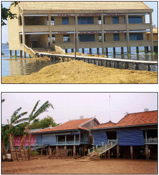
Figure 6.12: Structural
flood mitigation measures implemented in the delta schools
and houses raised on piles.
The complex fluvial geomorphological consequences of ‘hard’ flood control and mitigation measures need to be better understood since bank erosion during the flood season is becoming a serious issue in parts of the delta region.
___________
1 It is recognised
that the current flood alarm levels in the Delta are too low
given the flood protection works that have been completed
over the last decade or so. It is planned to reassess them
in the coming months
Choose a newsletter: