


Действия с Документом
 Project Rationale
Вверх на один уровень
1. PROJECT RATIONALE
The Dnipro River (Dniepr in Russian, Dnieper in English), which is one of the largest Europe’s rivers, rises in the vicinity of the village of Dudkino (Sychev district, Smolensk region) and flows across the three Slavic countries – Russia, Belarus and Ukraine. The river-head area represents a gently sloping and hilly plain gradually descending into a gently wavy morainic plain which in places becomes marshy.
The lowering of the ground level is most visible to the east of the river source, i.e. in the watershed area separating the Dnipro Basin from the small river sub-basins of the Volga River Basin. The area is distinguished by underdrained depressions of ground level represented by peatlands with the largest ones being located in the watershed area. These are represented by surface deposits and are located to the south of the Akseninskiy Mokh and Lavrovskiy Mokh and to the west of Ushynskiy Mokh – the area where the Dnipro River originates.
The river headwater area represents a unique watershed juncture of the sources of Europe’s three major rivers – the Volga, the Dnipro and the Western Dvina. It is within this area that the watershed line between these rivers lies and in this sense this region is unique and distinct from all the others. Here within an area of several tens of square kilometres rise the Dnipro River proper, its several small tributaries, the Obscha River (one of its major tributaries), the Western Dvina (at its source), its several small tributaries and a Volga River tributary of the 4th- 5th order (part of the Vazuza River Basin).
This area has always been sparsely populated because of its numerous wetlands which cannot be converted to agricultural land. Most of this area is covered by forests. Populated centers were mostly located in the upper part of the watershed area which is within easy reach of the Dnipro River source, namely to the north, north-east and west of the river source.
Within several hundred meters to the north of the river source stood the village of Klechi. Approximately 1 km west of it was the village of Aksenove, further on was located the village of Zabolotiye and northward the village of Dudkino. Located approximately 2 km further downstream was the village of Stvolovka. Of all these villages only the village of Dudkino has survived to this day with only a few people still living here. Its chance of survival is practically nil. The villagers farmed only nearby land and some stretches along the left bank of the Dnipro River.
At the present time the watershed area is almost completely covered by forest and shrubbery. All this land has not been farmed since the early nineties. Over the past 10 years scrub forest and shrubbery have replaced most of the arable land, particularly along the Dnipro River banks. Land surrounding to the villages and on the left bank of the Dnipro River is owned by a private farm. The remaining watershed area is covered by forests managed by the State Forestry Fund.
By the resolution of the regional executive council of 10/01/1981, the Dnipro River source was identified as a nature heritage site of regional significance. However, taking into account that the Dnipro River is one of Europe’s major rivers, and considering the uniqueness of the area adjacent to the river source, which represents a watershed separating the basins of three major rivers, it is advisable to elevate the entire area to specially protected areas of a higher status, and declare it a state complex landscape preserve “The Dnipro River Source”.
The contributing factors include: environmental conditions only slightly affected by human actvity, low population density, and almost complete absence of agricultural land. Hence, the river flow formation and conditions have remained almost unchanged.
Thus, the reserve will embrace the sources of the Dnipro, Dneprets and several nameless watercourses flowing into the Dnipro River as well as of the rivers such as Viazovets, Obscha, Chernogrizka (Western Dvina River basin), Vodlivka, Krmena, Rakitnia, and Lussa (Volga River Basin).
The report sets out the findings of a survey of legal documents establishing specially protected areas, preliminary estimates of the environmental potential of the surveyed area (climatic conditions, physical, geographical and landscape characteristics, and biodiversity). The report also presents the rationale of the proposal to identify this area as a specially protected area. The report includes proposals to grant this area a federal status as well as proposals concerning the regulation of economic, legal and other activities and the geographic demarcation of borders of the proposed specially protected area.
Figure 1 represents the borders of the planned Nature Reserve, which occupies a very diverse and high biodiversity level territory.
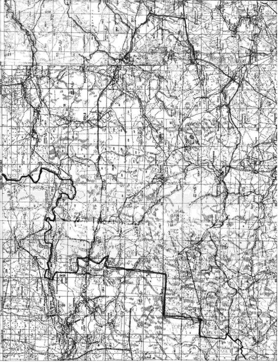
Figure 1.1. Chart of the “Dnipro Source”Nature Reserve