6. Conclusions and Recommendations (cont')
6.2 How to improve the annual flood report
Refining the objectives of the report in line with the FMMP
The Annual Flood Report is in line with the FMMP strategy and its components. It obviously stimulates the exchange of data throughout the four LMB countries. Additionally, it could become, indirectly, a complementary tool for a pragmatic monitoring of some FMMP activities and a tool for supporting the decision makers when addressing the flood issues.
If such orientation is expected, it would be necessary for the National Mekong Committees and the Line Agencies to refine the objectives of their annual flood reports in regard to the FMMP objectives and components and adapt the methodology and approaches accordingly. It could be recommended, for example, that chapters are developed, addressing and/or monitoring specific themes such as procedures for exchange of data, effect of infrastructure on flood and damage from flood, trans-boundary topics, land management issues and flood warning activities.
Setting up efficient and coherent procedures for collecting indicators and data related to flood events
The preparation of the national annual flood reports must start during the flood period, rather than a few months later. Direct observations in the affected areas may be done together with the emergency teams and institutions in charge of managing the flood events. Advice may also be given when monitoring the flood impacts. In the future, the key content of the annual flood reports should be based on coherent databases established at a national level in which all the relevant indicators are included. These databases must nevertheless be as simple as possible to be manageable at district level (or any other institutional level according to the needs of each of the countries). At this stage the consolidation of data would be an easy process and the "National Annual Flood Report" would only require additional elements of analysis and validation of data; including a description of the cause and mechanism of the floods supported by hydrological data, maps and interpreted satellite imagery where necessary.

This Annual Flood Report was prepared by organising numerous meetings at provincial, district and village levels. Those meetings allowed reconciliation of many data, at least in the most affected areas. The people affected are well aware of the narrow limit between beneficial and damaging floods. These meetings with institutions in charge of managing the flood, villagers or people affected, who are generally the best keepers of the memory of the flood events, remain essential. They also reveal the human aspect of the flood which does not appear in the starkness of damage lists. This field work should be conducted during the flood season rather than a few months later and if simple procedures for standardising data collection and data flow are set up, it could be simplified.
The scaling of the data is also an important topic. Data can be made available with breakdowns by provinces, by districts, by communes or even by villages. Actually, some key indicators, eg "loss of paddy fields", should be screened to the largest scale as possible, at least at the district level, because it allows, as seen in this report, for the creation and/or verification of valuable flood maps. For other indicators, such as "damage to roads", data at the provincial level should be enough. All these considerations require some preparation work to be carried out in close collaboration with the four MRC member countries. The following topics should be tackled:
- Refine the expected objectives and outputs of the annual flood reports
- Set up the list of indicators, data and documents to be collected at country level during the flood period, considering both indicators related to damage but also, when possible, some indicators related to the ben efits of the flood.
- In addition to the data available at MRCS level, obtain additional hydrological data such as rainfall and water level in the main tributaries, as well as the most updated rating curves to calculate the flow in the Mekong River.
- Envisage access to data related to the operation of the main regulation infrastructure in order to improve the analysis of the flood graphs.
- Better define the content of the indicators and the units for quantity estimates
- Define the procedures for data flow and data validation at national level and procedures to improve access to those data by MRCS team.
- Define the scheduling for data gathering and validation in order to produce the annual flood report within a reasonable time limit.
- Precise the institutional framework for the whole process including collaboration and contracts to be set up for an easy implementation and identify the needs for training.
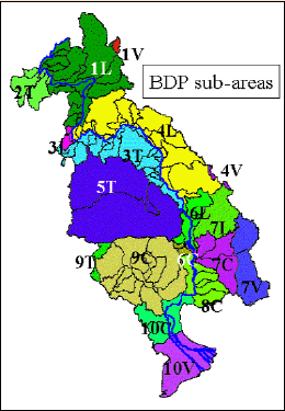
Figure 20: Definition of BDP sub-areas
of the LMB
A matrix indicating the scale of data (province, district, and commune level) for each of the collected indicators must be set up. Scaling to the commune (village) level is certainly ideal. It allows us to draw precise maps of the flood damage which can be combined with images of the flood extension. It also makes work at sub-basin level possible, in addition to the administrative levels. This work consumes resources and might only be practical for key indicators (e.g. loss of paddy fields). In this framework, a link with the BDP (Basin Development Programme) could also be envisaged.
1.Northern Lao PDR
2.Chiang Rai
3.Nong Khai/Songkhram
4.Central Lao PDR
5.Mun/Chi
6.Southern Lao PDR
7.Se San/Sre Pok/Se Kong
8.Kratie
9.Tonle Sap
10.Delta
Geographical Information Systems (GIS)
GIS is an appropriate tool to illustrate floods. In this report, it was shown to what degree GIS can support the presentation of data in a quite self explanatory way. Nevertheless, some layers located at MRCS level have proved to be out of date or not standardised. This is the case, for example, for some administrative layers (eg districts); names are not written in a standard way or administrative boundaries have been modified without having been changed in the MRCS database. This makes automatic operations of "combining" files of flood data with existing GIS files impossible and requires complex data handling.
It is therefore recommended that MRCS, together with the NMCs and LAs, draws up a list of standard GIS layers with specific use for flood monitoring, and keeps them updated and standardised accordingly.
Choose a newsletter: