6. Conclusions and Recommendations (cont')
6.3 Monitoring of flash floods
Flash floods on the tributaries of the Mekong River caused considerable damage in 2005 Such flash floods occur almost every year somewhere throughout the LMB. Means of monitoring, predicting, managing and mitigating flash floods are, however, different from dealing with floods occurring on the mainstream and in the floodplains of Cambodia or the Mekong Delta in Viet Nam. A decision must be made on whether to include flash floods on tributaries in the next MRC Annual Flood Report. If so criteriawill have to be established to determine specific on locations in the LMB or decide if it would it be better to focus on key watersheds, and which ones should be selected.
6.4 Satellite images
Observing flood events through satellite imagery provides valuable information. However, the agencies that are used to making such observations are not always concentrated on events in the Mekong area. For example interpreted images of the 2005 flood could not be found in the MRCS library. Each Annual Flood Report should be illustrated with satellite images showing the extension of the flood areas. Those images and the way of interpreting them should be standardised, making comparison from one year to another easier and more accurate. This work was done in the past, but on a "one-shot" basis. For example, MRCS was able to obtain images and interpretation for floods 2000 and 2001 in Cambodia's flood plain when the emotional effect of those damaging floods fostered this work.
For preparing this report, two institutions were contacted : Dartmouth (http://www.dartmouth.edu/%7Efloods/) and the Canadian Space Agency together with Hatfield Consultants Ltd (http://www.space.gc.ca/asc/index.html) which has supported MRCS in the past. The Dartmouth Flood Observatory was kind enough to send the interpreted images for years 2000 to 2005. But while years 2001 to 2004 have been widely analysed, unfortunately 2000 and particularly 2005 were poorly covered. The Canadian Space Agency/Hatfield Consultants Ltd offered its support to prepare a map for the areas affected by the flood 2005. They prepared the image shown in the Cambodian section of this report covering Kompong Cham Province.
Proactive collaboration with institutions or companies able to provide satellite images of flood events is recommended. During a serious flood event, actions may be taken in near-real time to get the most comprehensive images possible through the services from these institutions or companies. Images and data related to rainfall distribution and cyclones are also available in near-real time on the Internet (e.g. http://trmm.gsfc.nasa.gov/ and http://www.solar.ifa.hawaii.edu/tropical/ ).
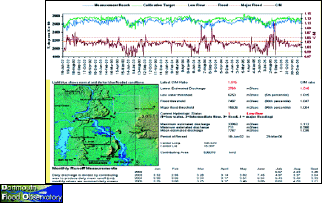
Figure 21: The Darmouth Flood Observatory
proposes daily observation of the discharge in the Mekong at
Pakse, based on the interpretation of satellite image (http://www.dartmouth.edu/~floods/)
6.5 Extension of flood markers
In Cambodia, several flood markers have been installed at village level with volunteers making daily observations during the flood period. Such flood markers could be extended in other flood risk areas as these could provide very useful information related to the extension of the flood and "in situ" for interpretation of aerial photographs or satellite imagery.
Choose a newsletter: