

7. Impact of the 2005 flood - Country reports
7.1 Impact of the 2005 flood in Cambodia
7.1.1 Background
Floods are an essential contributor to the wealth of biodiversity, abundance of fish and soil fertility in Cambodia. This is especially true for people living in the floodplain, downstream of Kratie where the area is very flat and there is extensive lateral flow of floodwaters from Kratie to the border with Viet Nam. Up to 4 million ha of lowland areas in Cambodia are inundated annually.
In the floodplain of Cambodia, people live with the annual flood and even if the flood is severe, they are accustomed to managing the situation year after year. The water level must be high enough to allow inundation of large areas, bringing sediment for soil and nutrients for fish, as well as to kill rats and other undesirable vermin. However, beyond a certain limit, the flood may be disastrous, killing people, destroying houses, rice fields and infrastructure.
The flood is commonly seen as a source of profit rather than a source of disaster. At the same time, floodvulnerable communities must be prepared to face severe flooding events if they are to minimise the number of victims and damage. The rural communities contribute widely to two vital sectors of the Cambodian economy, fishing and rice production and need support when an emergency occurs , but also during the "after flood rehabilitation period.
The flood in the Cambodian floodplain is vital to fishing
and navigation, but it may also be damaging.
The years 2000, 2001 and 2002 caused huge damage in terms of human life and economic loss. In 2000, severe flooding affected 22 out of the 24 provinces in Cambodia, with a death toll of 347 people, of which 80% were children. More than 3.4 million people were affected and physical damage totalled US$161 million. The flood in 2001 killed 62 people and the total estimated losses were US$ 36 million. Again, in 2002, floods hit the Mekong countries. In Cambodia alone, the flood killed 29 people and the total extent of damage was over US$12 million. On the contrary, years 2003 and 2004 were very mild flood years and led to drought issues. The 2005 flood, described in this report may be considered as positively "balanced".
7.1.2 Availability of Data
In Cambodia, data regarding flood damage are centralised firstly at provincial level through the Provincial Committees for Disaster Management (PCDM). All authorities involved in flood management and mitigation are members of the PCDMs, and they may include involvement by NGOs active in flooding issues such as the Cambodian Red Cross and Action Contre la Faim, amongst others. A provincial report is then produced every year. At central level, the National Committee for Disaster Management (NCDM) issues a summary report covering the whole country. On specific occasions, for example, when an MRC Annual Flood Forum is organised, data from the NCDM reports are gathered and reported at regional level.
The reports established at provincial levels are likely to be the only means of obtaining the most reliable information related to the 2005 flood. The information is consolidated up to the district level in some provinces. There is no standard format for establishing the annual reports at province level, rendering the consolidation problematic by lack of data consistency, typology of damage and standardisation of assessment. The figures presented in this report therefore need to be interpreted cautiously.

For the time being it is not possible to obtain information detailed by communes or villages without undertaking a systematic retro-active survey, which would have been beyond the scope of this work. However, data regarding flood damage exist. The heads of communes and villages are able to present quite a precise picture of the flood in their area. They possess a deep knowledge of flood events and some records are kept in notebooks. Peoples memories are also a valuable source of information. The aim should be to organise procedures and obtain resources for gathering the information on a simple but coherent and reliable basis.
The province of Kompong Cham appears to be an exception. In this province, the NGO Action Contre la Faim is active in the implementation of the Early Warning System and Flood Preparedness Projects, under FMMP, funded by USAID/OFDA. Detailed surveys of flood damage breakdown by affected villages have been carried out. MRCS should explore the possibilities of reporting the annual flood throughout the Mekong Basin by setting up a similar approach, at least for the major indicators.
It is very difficult to obtain a clear idea of the financial damage caused by a flood. At village level, the communities do not have tools for making this estimate. At district or provincial levels, only large and key infrastructure are subject to an accurate estimate when there are plans for rehabilitation or reconstruction through a tendering process. Tendering recognised that staffs at that level are not trained enough nor did they have clear procedures for making assessments of the flood damage.
It is likely that severe flooding events like those that occurred in 2000, 2001 and 2002 were subject to a better assessment in terms of damage and economic costs, considering that reconstruction had to be supported by external funds. In case of a "balanced" flood, such as in 2005, local repairs and reconstruction are generally undertaken by the villagers themselves with sporadic support from NGOs. The repairs of district or provincial infrastructure are part of the regular maintenance budget and are not reported by the PDMCs.
7.1.3 Overview of impacts at the national level
The provinces of Stung Treng and Kratie were affected by high water levels in the Mekong River that created backwater in the lowest areas and in tributaries that could not drain easily into the river. The province of Kompong Cham was well flooded due to the high level (but not exceptional level) of the Mekong. The flooding situation in Kandal and Prey Veng provinces was recorded as "normal", the water level of the Mekong having decreased in intensity after the confluence with the Tonle Sap River. Additionally, some flash floods occurred in Battambang province (from a tributary of the great Lake).
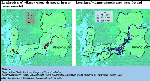
Figure 22: Example of possible data treatment
if more elaborate monitoring of the flood is set up (data from
the database "Action Contre La Faim, Kompong Cham")
The impacts on the flood are detailed in Figure 23 by provinces, and for two provinces by districts, according to the data made available for this report. Data were provided by the Provincial Disaster Management Committees and may sometimes differ from the data gathered at national level.
7.1.4 The most affected areas
The 2005 flood caused damage in four provinces in Cambodia: Stung Treng, Kratie, Kompong Cham and Kandal. The satellite imagery of the flood in the province of Kompong Cham was provided courtesy of the Canadian Space Agency and Hatfield Consultants Ltd.
Impacts on the people
The 2005 flood had negative impacts on the population of the provinces of Kratie and Kompong Cham where provincial authorities respectively recorded that 361 and 429 people were evacuated to safer places. This is an indicator of the severity of the flood. They also reported that 20 people died from flood, nine of these were male children, who are often the most vulnerable. The major reason is bathing accidents.
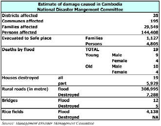
Figure 23: Estimate of damage caused by
the 2005 flood
in Cambodia
This table presents data provided by the National Disaster Management Committee. These data are different from the data obtained from the Provinces affected. For example, at national level, about 144, 000 people were affected by the 2005 flood. If we consolidate the figures from the four affected provinces located along the Mekong, they show that more than 275, 000 people were affected. The number of people who died due to flood also varies, when broken down into male and female and young and old. The definition of the indicators and the procedures for collecting and consolidating data at national level needs some improvement.
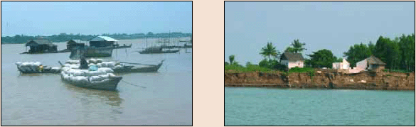
Damage to houses is difficult to estimate. No precise data were available for Stung Treng and Kratie. In Kompong Cham and Kandal, many houses were recorded as having been flooded and/or having suffered minor damage, but only few houses were destroyed. In many cases, the destroyed houses were built along the embankments of the Mekong and may have been washed away by bank erosion.
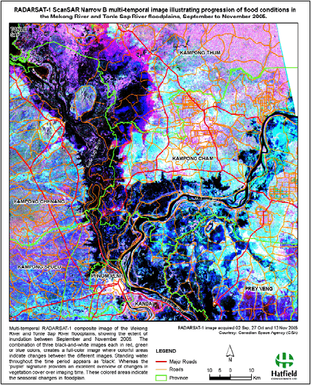
Figure 24: Satellite imagery of the 2005
flood in the province of Kompong Cham
(courtesy of the Canadian Space Agency and Hatfield Consultants
Ltd)
Choose a newsletter: