7. Impact of the 2005 flood - Country reports (cont')
7.2 Impact of the 2005 flood in Lao PDR (cont')
7.2.3 Overview of the impacts at national level
Flash floods occurred during 2005 in many provinces of Lao PDR, damaging roads and bridges, irrigation schemes and other village infrastructure such as schools, water supply and health centres. The most affected provinces are located in central and southern parts of Lao PDR. They had to face both flood from the tributaries and backwater from Mekong. In some places, the combined effect caused the severest flood event for more than 30 years. The most affected districts were located in Khammouan Province. Figure 28 is a tentative consolidation of the damage encountered during the 2005 flood in Lao PDR. Based on the analysis of inundated and damaged areas at country level, the flood in 2005 affected wider areas and lasted longer than the flood in 2002. It affected 84 districts, and roughly 480,000 people in 2,510 villages, mainly in the central and southern provinces of Lao PDR. The estimated total damage is more than US$18 million just for the sectors of agriculture and forestry. Roads were also damaged by the 2005 flood, some roads were cut off and some bridges were destroyed. The estimate of the total damage to roads was nearly US$8 million.
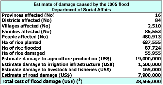
(') estimate damage to private infrastructure
not available
Figure 28: Estimate of damage caused by the 2005 flood in
Lao PDR
The table presents consolidated figures for 2005 flood as prepared by the Department of Social Affairs, National Disaster Management Office. The reconciliation of the figures from the different technical departments and from the different administrative levels (provinces, district, villages) is a complex operation. This is why some figures may differ from those obtained when analysing sectoral or regional situations. The NDMO is improving its database tools and better coherence and reliability of the data may be expected in the future.
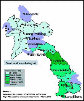
Deaths caused by flood are not systematically reported. Some figures exist for districts which were particularly affected, for example, 4 people died in the province of Savannakhet and 5 in Oudomxay. The direct impacts of floods on health are difficult to analyse and are not very well known. Some partial information is given further in this report at least for the most affected areas. Impacts on the people In Figure 29, the figures are broken down by provinces. Sources may be different from the national table but the final figures are eventually quite similar. Some data are also missing, but it may be assumed that in general when data are missing, it is likely that no exceptional damage occurred. It appears clearly that the provinces most affected by the Mekong flood are the southern provinces of Khammouan, Savannakhet and Champassak. Severe flash floods occurred also in Saravane, Oudomxay, Borikhamxay, Sekong and Huaphan Provinces.
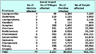
Source: Ministry of agriculture and Forestry
NDMO Oct 3 2005
Figure 29: Estimated number of people affected by the 2005
flood, by provinces
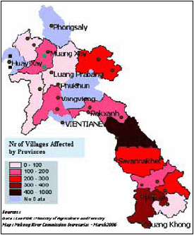
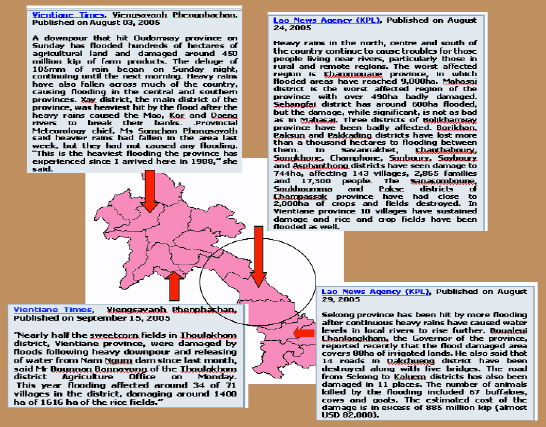
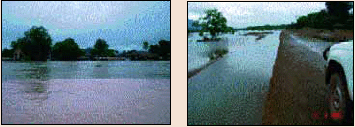
Figure 30: The successive events of the
2005 flood were widely reported in the Vientiane Times and
in the Lao News Agency (website laomedia.net).
In 2005 Lao PDR was severely affected by floods, the worst recorded since several decades. The effects were twofold: high water levels and, in some places, exceptionally long duration of flooding.
Impacts on Production Areas
The main source of information for estimating the impacts of the 2005 flood on agricultural production are the statistics dated 3rd October 2005 issued by the Disaster Management Focal Point of the Ministry of Agriculture and Forestry, NDMO. Nevertheless, in this document, the breakdown by province differs from the consolidated estimate of damage for the country. This is due to lack of data in some provinces and assessment from different sources. Although, the overall figures are quite comparable when considering the challenge of reporting damage at a national level.
The estimated number of hectares of rice lost by floods in 2005 varies from 44,479 to 50,215 ha on a total planted area of approximately 659,000 ha. This is nearly 8% of the planted areas, which is considerable if compared with the 34,000 ha loss in the 2002 flood, considered as the most severe flood in recent years.
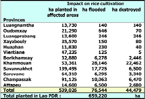
Source: Ministry of Agriculture and Forestry NDMO
Oct 3 2005
Figure 31: Estimated damage to agricultural
production from 2005 flood, by provinces
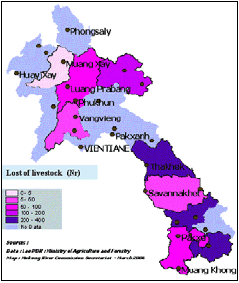
The impacts on livestock are also particularly heavy in areas where flash floods occurred. In such cases nearly no warning system is available and the people are not prepared for exceptional events. Heavy losses of livestock were recorded in Sekong, Saravane and Khammouan Provinces.
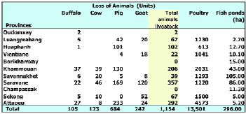
Source: Ministry of Agriculture and Forestry
NDMO
Oct 3 2005
Figure 32: Estimated damage to livestock from the 2005
flood, by provinces
Impacts on Infrastructure
Data concerning the damage to irrigation infrastructure are not exhaustive. This is due to a lack of procedures and expertise for covering this sector.
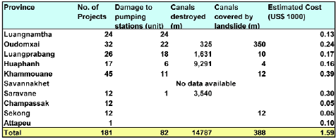
Source: Ministry of Agriculture and Forestry
NDMO Oct 3 2005
Figure 33: Estimated damage to irrigation infrastructure from
the 2005 flood, by provinces
Choose a newsletter: