7. Impact of the 2005 flood - Country reports (cont')
7.2 Impact of the 2005 flood in Lao PDR (cont')
7.2.4 The most affected areas
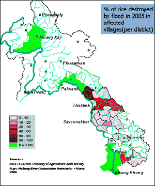
Figure 34: Percentage of destroyed paddy fields,
breakdown by districts
As shown, the 2005 flood affected numerous provinces in Lao PDR. Nevertheless, it is commonly admitted that the most affected districts were those which experienced both backwater from the Mekong and flooding from the tributaries. Those areas suffered from an exceptionally long duration of the flood. The analysis is more meaningful when examined by district. The Districts of Hinboun and Nongbok in Khammouan Province were generally considered the most affected by flood in 2005.
Figure 34 shows a breakdown by districts illustrating the situation in terms of rice production. The three parameters of planted rice, flooded rice and destroyed rice are suitable indicators for estimating the severity of the flood for two reasons: firstly, these parameters are generally recorded at all levels, village, district and province; and secondly, they integrate to a certain extent two essential parameters which characterise the flood - extension and duration. The flooded areas may give an idea of the extension of the flood, and the destroyed areas indicate roughly where the flooding period exceeded two weeks. This table also shows that, although these indicators are essential for characterising the flood and are representative of the most important damage suffered by farmers, many data are missing. It does not necessarily mean that the data were not recorded, but most likely that the communication channels for making the information available at central level (NDMO) did not run properly.


Figure 35: Percentage of affected villages, by district
The Team in charge of preparing the MRC Annual Flood Report 2005 visited two affected provinces: Khammouan and Savannakhet. This visit included meetings with the Provincial and Distrtict Authorities (with participation of the technical departments) and visits to some particularly affected villages. Informal discussions with the chief and villagers allowed the Team to get a better understanding of the severity of the flood, and the way the villagers and authorities tackled this difficult situation before, during and after the flood period. Testimonies of villagers were recorded during this field trip.
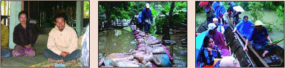
The village of Chokbo, District of Nongbok, Province of Khammouan was one of the villages most affected by the 2005 flood. The villagers reported:
"Our village is located along the Xebangfay river about 4 km from the district town and 6 or 7 km from the Mekong River. We are 108 families all are rice farmers. Fishing and vegetable gardens are activities only for household consumption. Our rice field area covers approximately 134 ha, all located in a flood risk area. Of this 77 ha are irrigated. The village has water and electricity. We are used to having a flood every year from the end of July to September. Every family has one boat on average. The oldest people remember the dreadful flood of 1972 where we recorded 1 m of water in the village and up to 3 m in the paddy fields, and this lasted more than one month.
Last year, in 2005, we had to face an even more serious situation. The water started to rise in the first week of August. We worked very hard fighting the inundation using sand bags. But on the 27th August we could no longer prevent the flood from entering into the village. At that time, the Mekong water level was getting very high and the extension of the backwater in the Xebangfay River was about 42 km. The water level reached more than 1 m in the village and nearly 3 m in the paddy fields. We had to face nine successive floods. The flood lasted for nearly 45 days.
Our paddy fields were totally destroyed. Other damage was fortunately limited. No one died, but several fish ponds and one house were damaged. The loss of livestock was limited to poultry. We received assistance from the district for food, water, medicine and 500 kg of seedlings for replanting, far under our needs. The impact of the flood on the villagers' health was limited to foot diseases, diarrhoea and fever.
On the other side of the river, just in front of us, is the district of Xaybuly, Savannakhet Province. Their villages are protected by an embankment. They were safer than us, but we think that we have been more severely affected by the flood because of this embankment. We can generally manage the consequences of flood ourselves, except for what is the most important for us, our paddy fields. Many families in the village are now fearful of replanting during the rainy season. We also need embankments and access roads.
We received good emergency support from the province and the district. They all did what they could, but we know that their means are very limited"
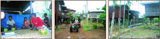
The Chief of Khengphoun village reported:
"This village is located in the District of Champone, Savannakhet Province. It has 546 inhabitants, 101 families and is entirely located in a flood risk area. All 183 ha of land planted with rice in the rainy season are located in this area. In 2005, we planted 166 ha and all of this has been lost. We are used to experiencing floods every year. We do not fear floods and we are prepared and well organised to manage it, but in 2005, it was exceptional. We do not remember such a serious flood since 1978. In 1978, we got 3.5 m of water in the paddy fields and 2.5m in the village, but the flood period was not so long.
In 2005, we "only" got 2.5m-3 m in the paddy fields and 1.5 m in the village. But it lasted from end of July to end of September. We had to face seven successive flood peaks. Paddy fields were flooded for 47 days, which is why we lost all the production. All the families in the village were affected.
Our problem with the flood in 2005 was its duration. We have TV and radio and we sometimes receive information from the district when a risk of flood is forecasted. But we also have our traditional way of predicting the flood, for example by observing trees. We prepare ourselves, and proceed with the evacuation of the livestock to safer places. It is why, in 2005, only three cows and six buffaloes were lost. But generally we do not lose livestock.
During the flood we were given support through the provision of dry food and drinking water. After the flood we wanted to replant, but we had to face the problem of getting seedlings. We received some from district, but far less than our actual needs; so many villagers could not afford to replant rice after the flood."
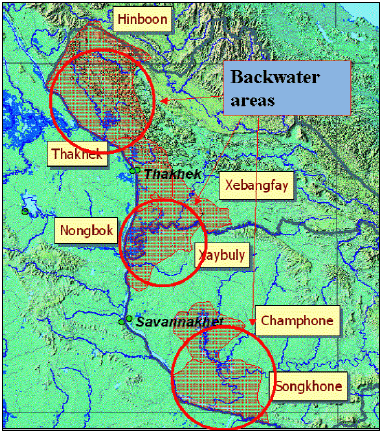
Figure 36: Districts most affected by
2005 flood in Lao PDR
People affected
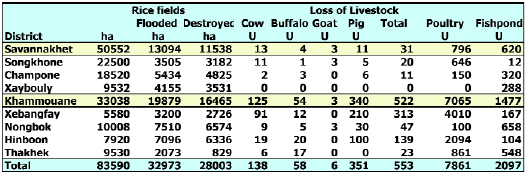
Figure 37 shows the extent to which people in these districts were affected. Four people died due to the flood in Savannakhet Province and more than 300 people were evacuated to safer areas in Khammouan Province. There was minimal damage to houses with only one house in Savannakhet Province and two in Khammouan Province reported as destroyed.
Agriculture and livestock
The most important damage caused by the 2005 flood was seen in the paddy fields. Long periods of flooding reduced the rice production by nearly 50% in the Province of Khammouan, approximately 90% in the district of Hinboun and 75% in the district of Nongbok. In Savannakhet Province, the district of Champone was also severely affected with loss of nearly 30% of rice production.
Damage to livestock was high as well. People are normally prepared for flood events and evacuation of livestock is a common preparation measure. In the case of the 2005 flood, water rose very quickly both in the Mekong and in the tributaries. Some villagers reported that the flood occurred overnight and they did not have sufficient warning to take action.

Source: Meeting of MRCS Flood 2005 team
with Provices/District Feb/March 2006
Figure 37: Damage to people in the most affected districts
Source: Meeting of MRCS Flood 2005 team
with Provices/District Feb/March 2006
Figure 38: Damage to agriculture production in the most affected
districts
Infrastructure
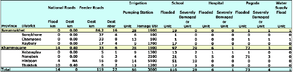
Damage to infrastructure was pieced together during a meeting with provinces and district authorities.
Source: Meeting of MRCS Flood 2005 team
with Provices/District Feb/March 2006
Figure 39: Damage to infrastructure in the most affected districts
Health
Some data were issued by the Department of Health in the province of Khammouan. These incidents may not have been directly induced by the 2005 flood. Typhoid cases are, for example, recorded every year. In 2005, 12 people died from typhoid in the Khammouan Province, but the relationship to flood events is not obvious. After interviewing the authorities and the villagers, it seems that people's health was not seriously affected by the 2005 flood. No epidemics occurred, and there is no mention of abnormal malaria. The major concern was clean drinking water and sanitation. District authorities provided treatment by chlorination of boreholes and supplied drinking water.
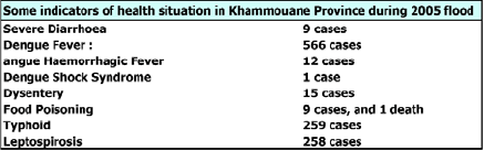
Source: Department of Health, Khammouan
Province
Figure 40: Health indicators in the 2005 flood in Khammouan
Choose a newsletter: