7. Impact of the 2005 flood - Country reports (cont')
7.3 Impact of the 2005 flood in Thailand
7.3.1 Background
The Mekong River Basin in Thailand is shown in Figure 41. It represents only 36% of the country separated in two areas. One is located in the mountainous and forested section (Province of Chiang Rai) close to the borders of Myanmar, China and Lao PDR and is subject to frequent flash floods.
The other area is known as the Mun-Chi River System. It covers the Issan region. The Mun-Chi river system, as well as other major tributaries such as the Songkhram river are highly developed low-relief basins with low runoff potential and significant reservoir storage for dry season irrigation. Wide low level plains are inundated every year. When the water of the Mekong is high, the combined effect of backwater from the Mekong and reduced drainage may cause serious flooding.
In rural areas, rice growing in paddy fields is the main activity, and these are the poorest and least developed areas in Thailand. The trend is therefore to develop infrastructure for securing production in case of flood and developing irrigation during the dry season. The economic and social justification of such a policy is strong. Simultaneously, however, there is competition with the protection of large territories of wetlands containing a high biological value and important fishing activities. These areas also provide water storage possibilities during the flood periods reducing peak floods downstream.
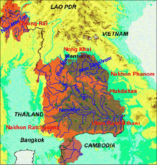
Figure 41: The Mekong River Basin in Thailand
Although flash floods may be considered as more damaging than beneficial, this is more relevant when speaking about the Mekong flood in the Northeast Region. Urban, semi-urban and rural areas located along the embankment of the Mekong are obviously affected when strong floods occur. The appreciation of flooding in the low plains depends on how land is being used. Farmers generally consider it harmful, while conservation advocates and fishers see it as beneficial. It is likely to remain a sensitive issue for years to come.
Floods caused by heavy rainfall near urban areas such as Nong Khai, Nakhon Phanom and Mukdahan are also a cause for concern in this area. Runoff increases in relation to increased surfaced areas. When the level of the Mekong is high, drainage becomes problematic. This was particularly the case in 2005 with substantial difficulties experienced in Mukdahan.
7.3.2 Availability of Data
Data related to damage from floods are recorded at tambon (commune) and district level by the Technical Departments mainly for establishing budgets and funding requests for repairs and reconstruction. From this information, in theory, the National Disaster Mitigation and Prevention Centre establishes lists of the major events at national level, broken down by province. Unfortunately, it appears that carrying out these reports is a long process and reports for 2005 were not available when we were preparing this annual flood report.
Data are available at provincial levels and experience shows that direct contacts with the provincial authorities are the best and, to some extent, the only, way to obtain access to information. Additionally, the data are not recorded consistently from one province to another. Some indicators are monitored in one province and not in another, rendering data reconciliation and consolidation at national level impossible, except for loss of rice production.
Recently, damage to agricultural production has been subject to cash lump sum indemnities rather than compensation in kind. For example, the loss of one rai (0.16 ha) of paddy field is compensated at the rate of 243 baht (approximately US$6). Damage is declared by the farmers to the Department of Agriculture and a field assessment is done for approval of the indemnities to be paid. Data on agricultural damage may therefore be considered as clearly identified and recorded. Nevertheless, the planted areas are not monitored in the existing process of collecting data related to flood damage. It is therefore not possible to estimate the loss in terms of percentage of planted areas, which is likely to be the most significant indicator of the severity of the floods. Those figures have most likely been collected but would require additional effort to obtain them.
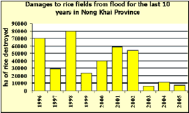
Figure 42: Damage to rice fields in the
last 10 years
in Nong Khai Province (Source: Province of Nong Khai)
In Nong Khai province, the loss of paddy fields due to floods has been recorded for the past 10 years. Unfortunately, those data are not linked to the planted areas, but are nevertheless a good indicator of the intensity of the floods that involve the Mekong-tributaries system.
Figure 42 shows that 1996, 1998 and 2001 were the most damaging years. Keeping records of annual loss of paddy fields could be an outstanding indicator for historical analysis of flood events.
7.3.3 Overview of the impacts at national level
The 2005 flood mainly affected two areas. The Northern region of Chiang Rai was affected by two flash flood events and the section of the Mekong starting downstream of Nong Khai province and covering the provinces of Nakhon Phanom and Mukdahan recorded high levels in the Mekong for a substantial period causing backwater from the Mekong to flood the lower areas. This was combined with intensive rainfall which considerably reduced the possibility of drainage from major tributaries to the Mekong. In addition, urban areas (mainly in Mukdahan) were severely affected by heavy runoff caused by rainfall which was unable to drain into the Mekong.
Mukdahan was severely affected by the 2005 flood. The combination of heavy rainfall and high levels of the Mekong restricted the drainage of runoff water.
Figure 43 tentatively attempts to consolidate the data related to the damage caused by 2005 flood in the Thai part of the LMB. This exercise is nevertheless very approximate. On one hand, it has not been always possible to distinguish clearly between missing data or zero data. Therefore, addition has been made, but is not consistent. On the other hand, we may expect that sometimes "no data" may mean that only minor damage occurred, making the figures quite close to a zero value.
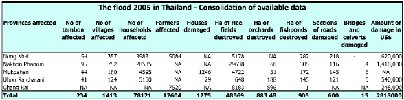
Source: Provinces, Disaster Prevention
and Mitigation Offices
Figure 43: Consolidation of available data on estimated damage
in Thailand
7.3.4 The most affected areas
The most affected areas during the 2005 flood in Thailand were in the downstream area of Nong Khai Province (reasonably affected) and the provinces of Nakhon Phanom and Mukdahan (badly affected). Further downstream, in the province of Ubon Ratchatani, less damage was recorded. The flash floods that occurred in the province of Chiang Rai were specific events not linked to the Mekong River itself, but some basic information on the damage caused is presented in this chapter as well.
7.3.4.1 Damage to agricultural production and extension of the flood
The damage recorded to agricultural production in the three provinces, broken down by districts are a good relative indicator of the intensity of the flood. The problems started in the District of Bun Khan (opposite Paksan in Lao PDR) and the worst places were situated in Nakhon Phanom Province, more especially in the low lying areas of the river Songkhram.
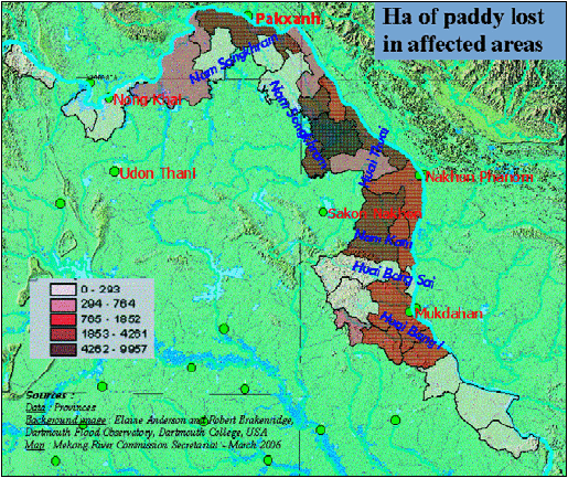
Figure 44: Hectares of paddy fields lost
in the affected districts.
Choose a newsletter: