8. Responses to flood events - Country Reports
8.3 Responses to flood events in Thailand
The institutional framework for disaster prevention and management is organised at national and provincial levels and coordinates all field operations. Specialised Units are generally made up of representatives from the Departments of Water Resources, Agriculture and Irrigation, Transport, Natural Resources and Environment, Health as well as the police service.
Loss of agricultural production due to flooding is compensated in cash, on a lump sum basis per ha and after a declaration by the farmer and assessment by the agricultural services.
Apart from these non-structural measures, a longer term strategy aims to limit the effects of the flood by building or reinforcing protection along the river. Several regulating structures have been built in the North Eastern Region. Roads along the Mekong River are heightened on embankments which also offer efficient protection for land and housing. More and more sections of the Mekong river bank have been protected against erosion, especially in larger villages, semi-urban and urban areas. Additionally, the protection of urban areas is underway. In Nakhon Phanom systems are in place which will pump water in the event of the town being inundated.
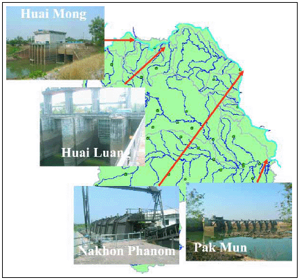
The Huai Mong Project, the Huai Luang project and the Pak Mun dam are the most important regulation structures located at the mouth of those tributaries with the Mekong River. In general these structures are multipurpose. Storage of water upstream of the structure and pumping in the Mekong during the dry season will bring water for irrigation. In case of heavy flooding in the tributaries, the flow to the Mekong may slow down, decreasing erosion. In case of high water levels in the Mekong, the gates are closed and backwater effect is controlled.
The objectives of such structures are therefore not only oriented to the mitigation of floods, but also provide solutions to water shortage problems allowing agricultural production throughout the year by providing irrigation.
To live with flooding or to increase protection? The case of the Lower Songkhram River
There is a tendency to report floods negatively in Thailand. Flooding occurs every year in the North East Region of Thailand as part of a natural, age-old pattern. There is much pressure from farmers for better flood protection in this area as well as calls to increase irrigation.
The case of the Lower Songkhram4 , affected by the 2005 flood, which covers parts of Nakhon Phanom, Sakhon Nakhon, Udon Thani and Nong Khai Provinces is typical. Heavy rainfall is recorded almost every year, and varies between 1,600 and 2,400 mm/year. A second factor leading to annual flooding is the influence of the Mekong River's level in inducing a backwater effect when river levels rise. Many villagers along the lower river report seeing reverse flows on tributaries carrying sediment rich waters from the Mekong flood into the Songkhram and say this helps maintain soil fertility on the floodplain.
The Songkhram River Basin resembles a large shallow lake, no deeper than 1-2m at most points, with trees and bamboo shoots protruding above the surface. The floods may extend up to nearly 2,000 km2 in a particularly "wet" year, although they are more typically around 1,000 km2. Villages have traditionally been located on levees or slightly elevated spurs of land above the floodwaters and are very rarely inundated, although access roads may be temporarily flooded requiring boat transport. Because of the regular annual nature of the floods the villagers are accustomed to flooding and have adapted their livelihood strategies accordingly. For example, cattle and buffalo are moved to elevated areas known as "dawn", which offer safe grazing and shelter, or are stable-fed under houses for the duration of the flood period. Rice cultivation in the rainy season is mostly limited to areas of low-risk to flooding, although some villagers do take the risk of planting seedlings in low-lying areas and losing their crops in higher than average flood years.
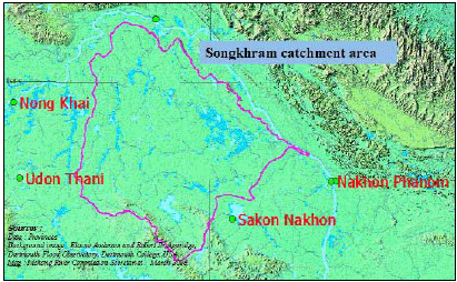
Figure 56: Songkhram catchment area in
Thailand
People have also developed a wide variety of fishing gears to harvest the flood recession fish migration, both to sell and to preserve for later consumption. In the case of certain species of migratory fisheating birds, their arrival from northern Asia to the Nam Songkhram wetlands would appear to coincide with the period of maximum fish migration. Floods in the Songkhram River Basin play an important role in the maintenance of natural wetland ecosystems, demineralisation of nutrients, groundwater recharge, sediment and nutrient retention. They also probably offer a level of protection from flooding for other land further down the Mekong valley, through temporary storage and gradual release of floodwaters which would otherwise flow directly downstream. Ultimately, the wide aquatic and terrestrial biodiversity and wetlands-based livelihoods found in the Lower Songkhram River Basin are closely intertwined and dependent on the natural hydrological and geomorphologic cycles of flooding. Any alteration to hydrological cycles or reduction in flooding duration and extent may have undesirable and negative impacts on biodiversity and local livelihoods.
Seeing floods only as a problem can lead to emergency interventions to alleviate or reduce flooding being implemented and, this, in turn, undermines the natural benefits that flooding provides. A well balanced and concerted land use policy, which integrates stakeholders' concerns as well as recognising the necessity to preserve the biodiversity as a highly valuable natural and economic asset, is a key factor when defining strategies and mitigation.
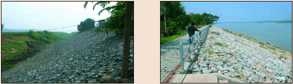
Every year protection of the Mekong embankment improves in urban and semi-urban areas, with priority going to the places most vulnerable to erosion. This provides considerable protection for the villagers whose houses were seriously threatened by floods in the past.
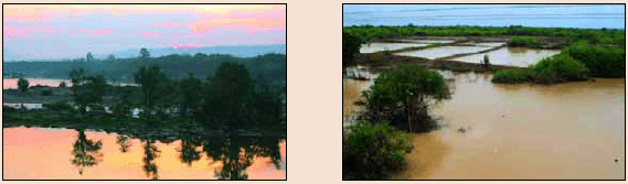
The development of infrastructure such as regulators and embankments provide good protection for villagers and their paddy fields. At the same time, they support the development of irrigation. However, they limit the natural inundation in the flood plains. Large floods are ecologically profitable: sediment-laden waters carry soils downstream, some of which are deposited on the floodplain each year, rejuvenating soils and adding nutrients to the food chain.
_______________
4Source : Mekong Wetlands Biodiversity Conservation and Sustainable Use Programme - Floods- Observation from the lower Songkhram river basin: joint UNDP-IUCN-MRC-GEF funded programme See Lit [6]
Choose a newsletter: