3. The 2005 Flood (cont')
3.2 Hydrological analysis of the 2005 flood
In the upper section of the Mekong, from the border with Myanmar (Chiang Saen) to Luang Prabang and Vientiane, the level of the Mekong throughout the season remained quite low, and no flood generated by the Mekong River itself was recorded. Nevertheless, several heavy rainfall events occurred, causing severe flash floods in the Northern Provinces of Lao PDR and in the Province of Chiang Rai of Thailand. In mid-September, due to excessive rainfall, water releases from the Nam Ngum dam caused damaging floods in the cultivated areas of Vientiane Province.
From the end of July to September 2005, the monsoon winds from the southwest and cyclones namely: Washi, Matsa, Vicenty and Damray produced heavy rains. The average rainfall in Lao PDR was far above the normal average, particularly in the provinces of Borikhamxay, Khammouan, Sekong, Saravane and Attapeu which normally record levels around 450 to 550 mm over this period. This generated many flash flood events in the central and southern provinces of Lao PDR.
These rains caused a dramatic increase in the water level in the Mekong River downstream of Borikhamxay, and especially in the section between Thakek to Savannakhet, Lao PDR. This situation affected nearly all the southern provinces of Lao PDR and the provinces located downstream of Nong Khai Province in Thailand, especially the provinces of Nakhon Phanom and Mukdahan. An aggravating factor was the heavy flows in the tributaries of the Mekong located in this critical section which occurred in the same period, from the end of June up to the beginning of September. This meant some districts located on these tributaries suffered from both backwater from the Mekong and flash floods from the tributaries. The drainage of the tributaries to the Mekong was slowed or even stopped, with the consequence that several villages received an exceptionally long period of flooding of over six weeks, the worst situation in nearly 30 years.
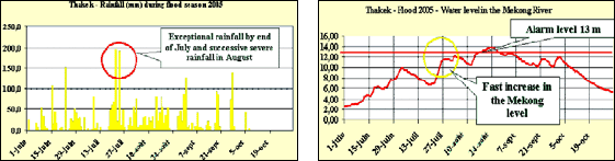
Figure 8: Hydrological rainfall and water
level Data of the exceptional flood 2005 at Thakek in Khammouan
Province (Lao PDR)
To the south, the situation was still critical in the provinces of Champasak (Lao PDR), Ubon Ratchatani (Thailand) although much less than upstream. The level of the Mekong was comparable to the level recorded in 2002, but below the 2000 level. Low areas in Pakse and Ubon Ratchatani were flooded, but for more limited periods. Heavy rainfalls were recorded in Saravane and Sekong Provinces causing very severe and damaging flash floods.
In Stung Treng, Kratie and Kompong Cham in Cambodia, a quite high water level in the Mekong River was recorded. Nevertheless, the situation was less exceptional and the damage was less severe than in the upper sections. The regulation of the Mun River in Thailand may have contributed to the avoidance of major damage downstream, but this has not yet been confirmed by running hydrological models on that event. A normal flooding situation was recorded throughout the Mekong Delta below the confluence with the Tonle Sap river.
The graphs in Figures 9, 10 and 11 illustrate the hydrological analysis of the 2005 flood, using data from selected major hydrological-stations along the Mekong River to compare hydrographs and monthly rainfall, as well as comparative rainfall intensity during the 2005 flood season.
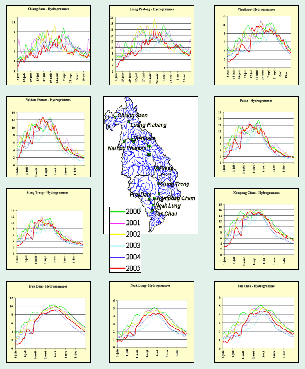
Figure 9: Hydrographs of the flood period
at major hydrological stations along the Mekong River
Choose a newsletter: