3. The 2005 Flood
3.1 Overview of recent flood periods
In order to obtain a reasonable idea of how severe a flood is, each new flood event must be compared with past events. The information in Figure 5 shows years where the maximum flow of the Mekong River was recorded since data was systematically collected. Only stations where there were complete records have been included.
Year 1966 was obviously the worst year in the upper part of the LMB, with its effects extending to Pakse. Year 1978 was the most serious flood for the area south of Mukdahan (Savannakhet) up to the confluence with the Tonle Sap river in the flood plain of Cambodia. Year 1996 recorded a severe flood, but it was limited to the area of Stung Treng at the confluence with the Sekong River.Years 1961, 1966 and 2000 were nearly equally devastating years for the Mekong Delta, although 2000 was seen as particularly damaging and remains memorable to all the people living in the floodplains. Year 2005 is definitely the most severe flood for the central area of Lao PDR and Thailand (Nakhon Phanom, Thakek, Mukdahan and Savannakhet). In second ranking: years 1971, 1974, 1984, 1991, 1995 and 2002 may also be considered as severe for one or another section of the LMB.
A severe flood is therefore a quite common situation in the LMB. But localisation of such events varies from one year to another which is why it is locally considered as exceptional. For example, very few people, even those familiar with the hydrology of the Mekong, are aware that 2005 was an "exceptional" flood. The Mekong River system, and its outstanding capability for storing water in low lands, is very complex in terms of hydrology. There are different possible scenarios which vary according not only to the duration and depth of rainfall, but also to the period in the flood season when rainfall occurs, and whether the lowland storage capacities are still available or not.
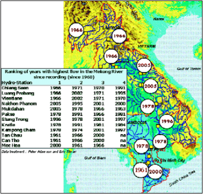
Figure 6: Years with maximum flood discharge
Another interesting analysis is the comparison of the past six years of flooding in terms of flood peaks and durations for a number of locations along the mainstream. The graphs in Figure 6 show the number of days in each year where water level has exceeded peak values. The section of the Mekong from Chiang Saen to downstream of Vientiane was not particularly critical during 2005, in comparison with the worst year in 2002. However, in the next section, from Nakhon Phanom to Pakse, the peak water level in the Mekong and the duration of the peak were the worst for the past six years. Downstream of Pakse, up to the confluence with the Tonle Sap, the water level in the Mekong stayed at the warning levels for a long period, but without being abnormal and definitely far below the situation recorded in 2000, 2001 and 2002. In the Mekong Delta, the 2005 flood was acceptable, with many days with a high water level, but no days exceeding warning or flooding limits.
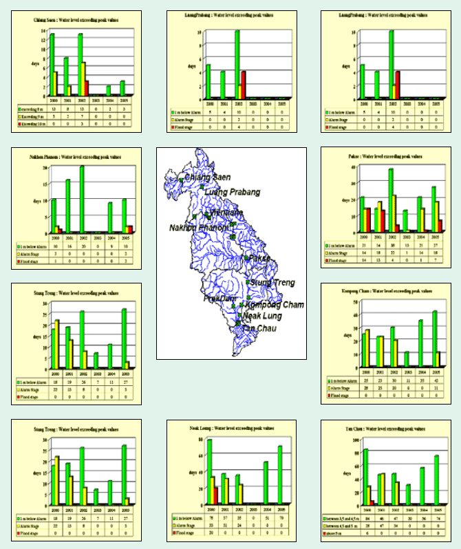
Figure 7: Water levels exceeding peak
values in hydrological stations along the Mekong River
Choose a newsletter: