2. The flood in the Lower Mekong River Basin (cont')
2.5 The Flood
The flood in the LMB is far from being a uniform phenomenon. It is useful to establish a typology of the floods. This typology should be divided into five categories.
Flash floods are floods that
occur in the tributaries of the Mekong River after intense or
long periods of rain in the catchment. Water in the stream rises
fast, water velocity may be very high, but the duration of such
a flood is limited to a few hours up to a maximum of a few days.
The flash floods are totally independent of the water level
in the Mekong River and may occur at any time during the rainy
season. It might only be possible to predict such flood events
by observing rainfall and water levels along the tributaries
where flash flood tend to happen. Flash floods are common in
the mountainous areas of the LMB. In those areas, floods are
largely considered harmful to people, cattle and infrastructure.
Paddy fields are less in danger as the duration of the flood
is limited. The mitigation measures for limiting damage from
flash floods consist mainly of regulating land use, in avoiding
settlement and human activities in risky areas, and, where possible,
diverting water from areas liable to flooding. Dams and reservoirs
built upstream of the flash flood risk areas may contribute
to the reduction of flash floods. Last but not least, the conservation
of the forest covering is a key factor for reducing the runoff
and flash floods.
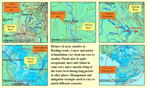
Figure 5: Typology of flood events in
the Lower Mekong Basin
Floods in the Mekong River are
floods caused by high water levels in the mainstream. The water
level may
overflow lower sections of the embankment or local backwater
may occur in ditches or small tributaries.
Additionally, if there is heavy rainfall at the same time in
areas where runoff is substantial (urban areas), there may be
limited or no drainage. The flooding period is limited to the
time the water level in the Mekong is at its highest, generally
not more than one or two weeks. Flooding is seen as damaging
as it may wash out infrastructure and houses. Casualties and
loss of cattle are generally limited as the flood may be predicted
easily by observing the water level of the Mekong, making preparedness
easier. The limited duration of flooding does not have much
effect on the rice production. Mitigation measures for limiting
damage from such floods consist mainly of regulating land use,
of limiting settlement and human activities in the risky areas,
of diverting the flood to wetland areas where possible and of
building embankment protection in urban areas or areas where
important assets need to be protected.
Combined floods are floods that occur in the downstream section of large tributaries, close to the outflow into the Mekong mainstream. Those areas are often shallow areas or wetlands. Severe flooding events may be recorded if two conditions are simultaneously fulfilled: high flow in the tributary and a high level of the Mekong. When the level in the Mekong is high, backwater flows into the tributaries and prevents, or slows down, the drainage into the Mekong. Large areas may be flooded for long periods. People living in such areas are accustomed to facing flood situations and are more prepared than people living in "flash flood" risk areas. Flood is essentially seen as harmful by farmers, but at the same time they recognise that backwater is source of soil fertility and is favourable for fish reproduction. Damage caused by such floods is mainly limited to rice fields, particularly in the case of long periods of flooding. Infrastructure such as roads, culverts, irrigation canals and pumping stations may be damaged by erosion. Wetlands are highly valuable for biological diversity and fish reproduction but also for storing water and reducing peak values of the water level in the downstream sections. The mitigation measures for limiting damage from such floods consist of improving land use regulations and making clear delineations between wetlands areas and areas for agriculture. Embankments and, regulators (colmatage canals) with gates aimed at controlling backwater from the Mekong may be efficient if the management of such infrastructure still allows "normal" flooding in order to avoid adverse effects on the environment.
The flood in the Cambodian flood plain is characterised by lateral flows of the Mekong from Kratie to the confluence with the Tonle Sap River and in the Tonle Sap basin and great Lake itself. Up to 4 million ha of lowland areas in Cambodia are inundated annually. Floods are an essential contributor to the wealth of biodiversity, abundance of fish and soil fertility. Yearly damage may be substantial, and preparedness is essential for decreasing accidents suffered by people and livestock. Damage by erosion is quite unavoidable. Damage to rice fields is recorded when the period of high water level flood lasts too long, but it must be taken into account that farmers are used to growing rice in risky areas knowing that there is a high probability they will lose production. Embankments and dykes may reduce the risk of flooding, but as human activities are largely based on fishing rather than agricultural production, the usefulness of increasing such infrastructure should be carefully studied. Helping the people to "live with floods" is likely the most appropriate option.
The flood in the Mekong Delta. The yearly flood is characterised by extended areas inundated by water from the Bassac River, the Mekong River and the numerous natural and artificial canals linking the two rivers that flow laterally to low lands. Sometimes, high water levels in the Bassac/Mekong systems may not drain easily to the sea due to tidal effect. This was the case during the severe 2000 flood in the downstream provinces of the Mekong Delta. Water level rises slowly for a long period. Every year there is substantial damage from these high water levels, primarily as a result of people drowning and from soil erosion damaging houses and infrastructure. Flooding is recognised as essential for soil fertility and biodiversity, but at the same time is perceived as an obstacle to the development of agricultural production and urbanisation. There is great pressure to protect land against floods by building dykes and backfilled areas. Land use planning and keeping the balance between socioeconomic and the environmental concerns remains a key issue for the future of the Mekong Delta.
Choose a newsletter: