2. The flood in the Lower Mekong River Basin
2.1 Catchment geography
From its source, the Mekong stretches about 4,800 km to the South China Sea, draining a total catchment area of approximately 795,000 km2 within the six countries of China, Myanmar, Lao PDR, Thailand, Cambodia and Viet Nam. The Mekong ranks 10th amongst the world's great rivers on the basis of mean annual flow at the mouth. The Greater Mekong can be divided into two parts: the Upper Basin in Tibet and China (where the river is called Lancang Jiang), and the Lower Mekong Basin from Yunnan downstream from China to the South China Sea.
The Mekong flows for almost 2,200 km from its source and decreases in altitude by nearly 4,500 m before it enters the Lower Basin where the borders of Thailand, Lao PDR, China and Burma come together in the Golden Triangle. Downstream from the Golden Triangle, the river flows for a further 2,600 km through Lao PDR, Thailand and Cambodia before entering the South China Sea via a complex delta system in Viet Nam. The Upper Basin makes up 24% of the total area and contributes 15% to 20% of the water that flows into the Mekong River. The catchment here is steep and narrow.
Major tributary systems develop in the Lower Basin. These systems can be separated into two groups: tributaries that contribute to the major wet season flow, and tributaries that drain low relief regions of lower rainfall. The first group are left bank tributaries that drain the high-rainfall areas of Lao PDR. The second group are those on the right bank, mainly the Mun and Chi Rivers that drain a large part of Northeast Thailand.
As the Mekong enters Cambodia over 95% of the flows have already joined the river. From here on downstream the terrain is flat and water levels rather than flow volumes determine the movement of water across the landscape. The seasonal cycle of changing water levels at Phnom Penh results in "flow reversal" of water into and out of the Great Lake via the Tonle Sap River. During the flood months, water flows up the Tonle Sap from the Mekong mainstream into the Lake. As the water level decreases in the mainstream in late September, water flows out of the Tonle Sap down into the Mekong mainstream. Nowhere else in the world is there a flow reversal this large.
The Great Lake on the Cambodian floodplain is the largest body of fresh water in Southeast Asia and forms one of the key features of the lowlands. The depth of the Great Lake increases from a dry season maximum of 3.6 m to more than 10 m, and the area of open water increases from approximately 2,500-3,000 km2, up to 13,000 km2. The seasonal storage of water in the Great Lake also acts as a huge natural regulator for water flows downstream of the Tonle Sap-Mekong confluence at Phnom Penh. This has some significant advantages in terms of the seasonal distribution of flows in the Vietnamese delta. As stored water flows out of the lake back to the mainstream during the dry season, the low flows in the Mekong are increased and are therefore higher downstream of Phnom Penh than they would be otherwise. The benefit is more water for irrigation and a reduction in saltwater intrusion in the delta.
The Mekong Delta begins in Phnom Penh, where the river divides into its two main distributaries, the Mekong and the Bassac. The Mekong then divides into six main channels and the Bassac into three to form the "Nine Dragons" of the outer delta in Viet Nam. The main delta is made up of a vast triangular plain which is lower than five metres above sea level, large areas of which are flooded every year. The movement of water within this complex channel network cannot be regarded as natural, due to the long history of modification. Levees were built hundreds of years ago along some of the main natural channels. Hydrology is not only dominated by the rivers but also by the tide, which has a large expansion in the dry season and which can slow down the drainage of the river during heavy flood periods, mainly downstream.
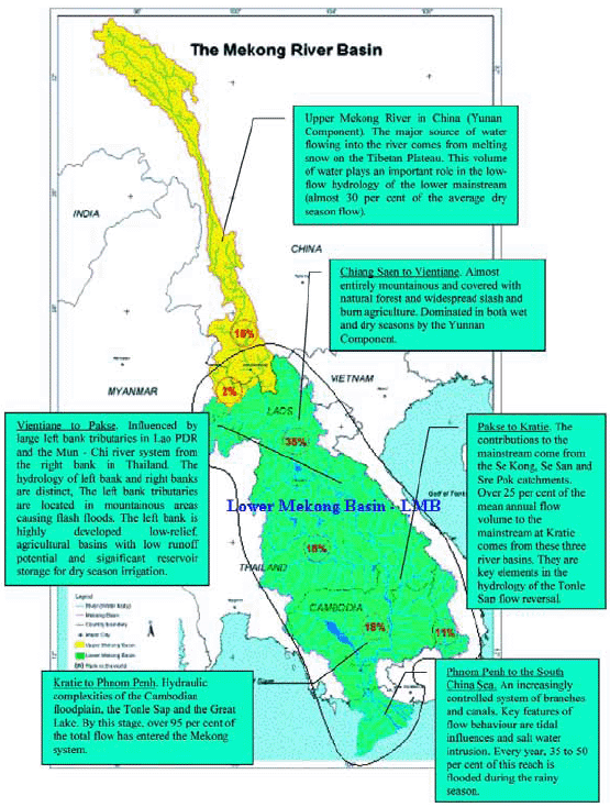
Figure 1: The Lower Mekong Basin
Choose a newsletter: