2. The flood in the Lower Mekong River Basin (cont')
2.2 The climate
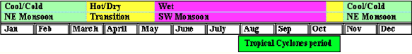
The climate of the Lower Mekong Basin is dominated by the Southwest Monsoon, which generates wet and dry seasons of more or less equal length. The flood period in the LMB corresponds to the Southwest monsoon season which usually lasts from May until late September or early October. There are usually heavy rainfalls during one or two days in most parts of the basin. Later in the season, tropical cyclones occur over much of the area so that August, September and even October (in the delta) are the wettest months of the year.
The Lower Mekong Basin is divided into six sub regions for the comparison of annual and monthly rainfalls and changes in space and time. Annual average rainfalls over the Cambodian floodplain and the Mekong delta are equally low and less than 1,500 mm. Elsewhere the highest rainfall is expected in the Central Highlands and within the mainstream valley at Pakse. Rainfall is less important in the more temperate northern regions around Chiang Rai. July, August and September are generally the months of highest rainfall, although there is evidence of a shift later in the season in Cambodia and in the delta where more rain falls in September and October.
Tropical storms and cyclones have a strong effect on the climate of the basin. This effect shows up as a double peak in rainfall distribution over most of the Lower Mekong Basin during a wet period or season, and the concentration of maximum rainfalls during the last quarter of the year in Cambodia and Viet Nam. Tropical cyclones over central and southern Vietnam show that the occurrence of the cyclones is more frequent in the period September to November, causing higher rainfall during these months, which may generate flash floods in the tributaries.
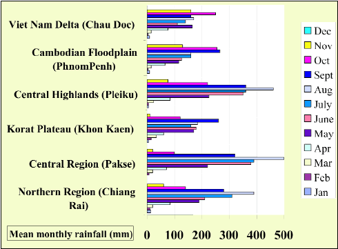
Figure 2: Rainfall pattern in the Lower
Mekong Basin
The Southwest monsoon, combined with severe tropical storms, is the cause of flood disasters in the Lower Mekong Basin, particularly in Cambodia and the Mekong Delta and even sometimes in the upstream part up to Vientiane*.
The seasonal range of mean temperatures in the lowlands and river valleys of the Lower Mekong Basin is not large. There are, however, significant changes, both season to season and from day to night at increasing altitudes and in the more temperate climates to the north. Mean summer temperatures during the period from March to October are similar within the lower basin from Phnom Penh, Cambodia to as far north as Luang Prabang, Lao PDR and Chiang Rai, Thailand. Annual rates of evapotranspiration range between one and two metres, with little variability from year to year, and combined with high relative humidity result in fairly constant annual values.
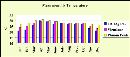
Figure 3: Mean monthly temperature in
the Lower Mekong Basin
*In 1966, Typhoon Phyllis was responsible for the most extreme flood recorded at Vientiane since 1913
Choose a newsletter: